
| ||||||
| ||||||
|
| Rwy | Rwy | |||||||
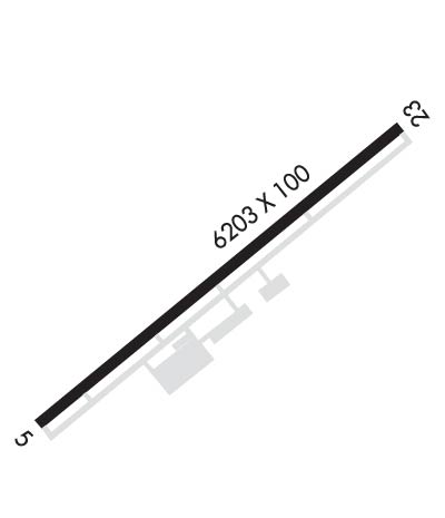
| 6202x100 | 6202' | 6202x100 | 6202' | 110.50 - 231° | ||||
| Runway ID | Single Wheel | Double Wheel | Double Tandem Wheel | Dual Double Wheel |
| 05/23 | 95,000 | 131,000 | N/A | N/A |
| These numbers are Advisory and are not limits. The Airport Manager should have more accurate Weight Limits | ||||
 Airport Diagram might not be current. | |
| Facility Name: | KYLE-OAKLEY FLD |
| City Name: | MURRAY |
| County: | CALLOWAY |
| State abbrev: | KY |
| State Name: | KENTUCKY |
| Ownership: | PUBLICLY OWNED |
| Use: | OPEN TO THE PUBLIC |
| Owner's Name: | MURRAY CITY-CALLOWAY CO BOARD |
| Address: | 544 AIRFIELD LN. |
| MURRAY, KY 42071 | |
| Owner's Phone: | 270-489-2414 |
| Manager's Name: | ANTHONY YOUNG |
| Address: | 544 AIRFIELD LN. |
| MURRAY, KY 42071 | |
| Phone: | (270) 978-0345 |
| FAA Region: | SOUTHERN |
| FAA Field Office: | MEM |
| Date | Sunrise | Sunset |
|---|---|---|
| 04/22/24 Monday | 6:10 | 19:35 |
| 04/23/24 Tuesday | 6:08 | 19:36 |
| 04/24/24 Wednesday | 6:07 | 19:36 |
| 04/25/24 Thursday | 6:06 | 19:37 |
| 04/26/24 Friday | 6:05 | 19:38 |
| 04/27/24 Saturday | 6:03 | 19:39 |
| 04/28/24 Sunday | 6:02 | 19:40 |
| 04/29/24 Monday | 6:01 | 19:41 |
| 04/30/24 Tuesday | 6:00 | 19:42 |
| 05/01/24 Wednesday | 5:59 | 19:43 |
| 05/02/24 Thursday | 5:58 | 19:43 |
| 05/03/24 Friday | 5:57 | 19:44 |
| 05/04/24 Saturday | 5:56 | 19:45 |
| 05/05/24 Sunday | 5:55 | 19:46 |
| Airport Attendance Schedule | MON-SAT 0800-1700, SUN 1300-1700; SVC AFT HR - AMGR. |
| Airport Status | OPERATIONAL (This Status can change at any time - please check NOTAMS) |
| Airport Lighting Schedule | ACTVT ODALS RWY 23; REIL RWY 05; PAPI RWY 05 & 23; MIRL RWY 05/23 - CTAF. |
| Airport Storage Available | Tie Downs, Hanger |
| Extra Services Available | Flight Instruction, Aircraft Rental |
| Wind Indicator | YES - (lighted) |
| Control Tower | NO |
| CTAF Frequency | 122.700 |
| Unicom Frequency | 122.700 |
| Rotating Beacon Color | WG |
| Segmented Circle | YES |
| Landing Fee | NO |
| Airport Inspected | STATE - performed by STATE AERONAUTICAL PERSONNEL |
| Inspection Date | 10/17/2019 |
| Type of Fuel Available | Grade 100LL, JET A |
| Airframe Repair Service | MAJOR |
| Power Plant Repair Service | MAJOR |
| Latitude | N3639.9 |
| Longitude | W08822.4 (ESTIMATED) |
| Arpt Elevation | 577ft (SURVEYED) |
| Magnetic Variation | 02W |
| 4 miles NW | of MURRAY |
| Traffic Pattern Altitude | |
| Sectional Chart | ST LOUIS |
| Operations (Reported) | Yearly | Avg. Daily |
|---|---|---|
| General Aviation Transient | 7500 | 21 |
| General Aviation Local | 7365 | 20 |
| Air Taxi | 950 | 3 |
| Commerical | 0 | 0 |
| Commuter | 0 | 0 |
| Military | 123 | 0 |
| Aircraft based on Field | |
|---|---|
| General Aviation Singles | 41 |
| General Aviation Multi | 2 |
| Jet Aircraft | 1 |
| General Aviation Helicopters | 0 |
| Military Aircraft | 0 |
| Gliders | 0 |
| Ultralights | 0 |
| FSS on field | NO |
| FSS tie-in | LOUISVILLE |
| FSS Phone | 1-800-WX-BRIEF |
| Who issues Notams | LOU |
| Notam D service at airport | YES |
| ARTCC Name | MEMPHIS |
| Airport Certification | |
| Aircraft Rescue & Firefighting Index | None |
| Airport of Entry | No |
| Custom Landing Rights | No |
| Joint Civil/Military | No |
| Military Landing rights | YES |
| NATIONAL PLAN OF INTEGRATED AIRPORT SYSTEMS (NPIAS) |
| GRANT AGREEMENTS UNDER FAAP/ADAP/AIP |
| ASSURANCES PURSUANT TO TITLE VI, CIVIL RIGHTS ACT OF 1964 |
| FOR CD CTC MEMPHIS ARTCC AT 901-368-8453/8449. |
Airport Communications & Frequencies:
| |||||||||
| Runway: 05 | Runway: 23 | ||
| Mag heading: | 52° | Mag heading: | 232° |
| Rwy Slope: | -.16% Down | Rwy Slope: | .16% Up |
| Approach: | Approach: | LOCALIZER | |
| Pattern: | Left Traffic | Pattern: | Left Traffic |
| Markings: | NONPRECISION INSTRUMENT | Markings: | NONPRECISION INSTRUMENT |
| Marking Condition: | GOOD | Marking Condition: | GOOD |
| Arresting Dev: | Arresting Dev: | ||
| Lat & Long: | N3639.5 W08822.9 | Lat. & Long.: | N3640.2 W08821.9 |
| Elev: | 577.3 ft. MSL | Elev: | 567.1 ft. MSL |
| TCH: | 29 ft. AGL | TCH: | 38 ft. AGL |
| Visual Glide Path: | 3.00 degrees | Visual Glide Path: | 3.50 degrees |
| Displaced Threshold: | No | Displaced Threshold: | No |
| Touchdown Zone: | YES | Touchdown Zone: | YES |
| Touchdown Elev.: | 577.3 feet | Touchdown Elev.: | 567.7 feet |
| Visual Glide Slope: | 4-Light PAPI on LEFT side of Runway | Visual Glide Slope: | 4-Light PAPI on LEFT side of Runway |
| RVR Equipment: | RVR Equipment: | ||
| RVV Equipment: | NO | RVV Equipment: | NO |
| Approach Lights: | Approach Lights: | ODALS - omnidirectional approach lighting system | |
| REIL: | YES | REIL: | NO |
| Centerline Lights: | NO | Centerline Lights: | NO |
| Touchdown lights: | NO | Touchdown lights: | NO |
| Runway Category: | Runway with a Non-precision Approach having visibility minimums greater than 3/4 mile | Runway Category: | D |
| Declared Distances: | Declared Distances: |
