Current Weather/Notams (Metars, TAFs, Notams, NWS Forecast, PIREPS, and nearby weather)
Customs Information Send updates to Support@FltPlan.com
Customs Not Available
Database effective 05/16/2024
Airport Diagram might not be current.
|
| Facility Name: | METTEL FLD |
| City Name: | CONNERSVILLE |
| County: | FAYETTE |
| State abbrev: | IN |
| State Name: | INDIANA |
| | |
| Ownership: | PUBLICLY OWNED |
| Use: | OPEN TO THE PUBLIC |
| Owner's Name: | CONNERSVILLE BOAC |
| Address: | 500 AIRPORT DRIVE |
| | CONNERSVILLE, IN 47331 |
| Owner's Phone: | 765-825-5581 |
| | |
| Manager's Name: | JEFF DUNGAN |
| Address: | 500 AIRPORT DRIVE |
| | CONNERSVILLE, IN 47331 |
| Phone: | (765) 825-5581 |
| | |
| FAA Region: | GREAT LAKES |
| FAA Field Office: | CHI |
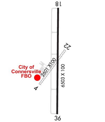
Runway Identifications
Runway Identification: 04/22Length: 2601 ft
Width: 100 ft
Surface: GRASS-GOOD CONDITION
Edge lights: Treatment: NONE
| | Runway: 04 | | Runway: 22 |
| Mag heading: | 40° | Mag heading: | 220° |
| Rwy Slope: | -.14% Down | Rwy Slope: | .14% Up |
| Approach: | | Approach: | |
| Pattern: | Left Traffic | Pattern: | Left Traffic |
| Markings: | NONE | Markings: | NONE |
| Marking Condition: | | Marking Condition: | |
| Arresting Dev: | | Arresting Dev: | |
| Lat & Long: | N3941.7 W08508.1 | Lat. & Long.: | N3942.0 W08507.8 |
| Elev: | 861.5 ft. MSL | Elev: | 857.8 ft. MSL |
| TCH: | | TCH: | |
| Visual Glide Path: | | Visual Glide Path: | |
| Displaced Threshold: | No | Displaced Threshold: | No |
| Touchdown Zone: | YES | Touchdown Zone: | YES |
| Touchdown Elev.: | 861.5 feet | Touchdown Elev.: | 861.5 feet |
| Visual Glide Slope: | | Visual Glide Slope: | |
| RVR Equipment: | | RVR Equipment: | |
| RVV Equipment: | NO | RVV Equipment: | NO |
| Approach Lights: | | Approach Lights: | |
| REIL: | NO | REIL: | NO |
| Centerline Lights: | NO | Centerline Lights: | NO |
| Touchdown lights: | NO | Touchdown lights: | NO |
| Runway Category: | Runway with a Visual Approach | Runway Category: | Runway with a Visual Approach |
| Declared Distances: | | Declared Distances: | |
Runway Identification: 18/36Length: 6503 ft
Width: 100 ft
Surface: ASPHALT-GOOD CONDITION
Edge lights: Medium IntensityTreatment: GROOVED
| | Runway: 18 | | Runway: 36 |
| Mag heading: | 184° | Mag heading: | 4° |
| Rwy Slope: | -.06% Down | Rwy Slope: | .06% Up |
| Approach: | ILS | Approach: | |
| Pattern: | Left Traffic | Pattern: | Left Traffic |
| Markings: | PRECISION INSTRUMENT | Markings: | NONPRECISION INSTRUMENT |
| Marking Condition: | FAIR | Marking Condition: | FAIR |
| Arresting Dev: | | Arresting Dev: | |
| Lat & Long: | N3942.4 W08507.8 | Lat. & Long.: | N3941.4 W08507.9 |
| Elev: | 866.2 ft. MSL | Elev: | 862.0 ft. MSL |
| TCH: | 47 ft. AGL | TCH: | 34 ft. AGL |
| Visual Glide Path: | 3.00 degrees | Visual Glide Path: | 3.00 degrees |
| Displaced Threshold: | No | Displaced Threshold: | No |
| Touchdown Zone: | YES | Touchdown Zone: | YES |
| Touchdown Elev.: | 866.3 feet | Touchdown Elev.: | 862.0 feet |
| Visual Glide Slope: | 4-Light PAPI on LEFT side of Runway | Visual Glide Slope: | 4-Light PAPI on LEFT side of Runway |
| RVR Equipment: | | RVR Equipment: | |
| RVV Equipment: | NO | RVV Equipment: | NO |
| Approach Lights: | MALSR - 1,400 foot medium intensity approach lighting system with runway alignment indicator lights | Approach Lights: | |
| REIL: | YES | REIL: | YES |
| Centerline Lights: | NO | Centerline Lights: | NO |
| Touchdown lights: | NO | Touchdown lights: | NO |
| Runway Category: | Precision Instrument Runway | Runway Category: | Runway with a Non-precision Approach having visibility minimums greater than 3/4 mile |
| Declared Distances: | | Declared Distances: | |
| Obstructions: | TREES | Obstructions: | |
| Marked: | NOT Marked/Lighted | Marked: | |
| Clearance slope: | 34:1 | Clearance slope: | 34:1 |
| Obstruction height: | 90 feet AGL | Obstruction height: | |
| Dist. from runway: | 3340 feet | Dist. from runway: | |
| Centerline offset: | 300 left of centerline | Centerline offset: | |
| Comments: | | Comments: | |