Current Weather/Notams (Metars, TAFs, Notams, NWS Forecast, PIREPS, and nearby weather)
Customs Information Send updates to Support@FltPlan.com
Customs Not Available
Database effective 04/18/2024
Airport Diagram might not be current.
|
| Facility Name: | CRETE MUNI |
| City Name: | CRETE |
| County: | SALINE |
| State abbrev: | NE |
| State Name: | NEBRASKA |
| | |
| Ownership: | PUBLICLY OWNED |
| Use: | OPEN TO THE PUBLIC |
| Owner's Name: | CRETE ARPT AUTH; BLAINE SPANJER, ACTING CHMN ADVISORY BOARD, PHONE 402-440-3153. |
| Address: | PO BOX 86 |
| | CRETE, NE 68333-0086; CITY OF CRETE, NEBRASKA |
| Owner's Phone: | (402) 826-7673 |
| | |
| Manager's Name: | WILLIAM WHITE; INTERIM MANAGER |
| Address: | 2429 COUNTY ROAD F, CRETE AVIATION |
| | CRETE, NE 68333-0014 |
| Phone: | 402-314-0887; 402-310-6124 |
| | |
| FAA Region: | CENTRAL |
| FAA Field Office: | NONE |
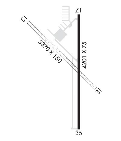
Runway Identifications
Runway Identification: 13/31Length: 3370 ft
Width: 150 ft
Surface: GRASS-FAIR CONDITION
Edge lights: Treatment: NONE
| | Runway: 13 | | Runway: 31 |
| Mag heading: | 130° | Mag heading: | 310° |
| Rwy Slope: | .13% Up | Rwy Slope: | -.13% Down |
| Approach: | | Approach: | |
| Pattern: | Left Traffic | Pattern: | Left Traffic |
| Markings: | | Markings: | |
| Marking Condition: | | Marking Condition: | |
| Arresting Dev: | | Arresting Dev: | |
| Lat & Long: | N4037.3 W09655.9 | Lat. & Long.: | N4036.9 W09655.3 |
| Elev: | 1491.4 ft. MSL | Elev: | 1495.8 ft. MSL |
| TCH: | | TCH: | |
| Visual Glide Path: | | Visual Glide Path: | |
| Displaced Threshold: | No | Displaced Threshold: | No |
| Touchdown Zone: | YES | Touchdown Zone: | YES |
| Touchdown Elev.: | 1494.3 feet | Touchdown Elev.: | 1495.8 feet |
| Visual Glide Slope: | | Visual Glide Slope: | |
| RVR Equipment: | | RVR Equipment: | |
| RVV Equipment: | NO | RVV Equipment: | NO |
| Approach Lights: | | Approach Lights: | |
| REIL: | NO | REIL: | NO |
| Centerline Lights: | NO | Centerline Lights: | NO |
| Touchdown lights: | NO | Touchdown lights: | NO |
| Runway Category: | Runway with a Visual Approach | Runway Category: | Runway with a Visual Approach |
| Declared Distances: | | Declared Distances: | |
Runway Identification: 17/35Length: 4201 ft
Width: 75 ft
Surface: CONCRETE-FAIR CONDITION
Edge lights: High IntensityTreatment: NONE
| | Runway: 17 | | Runway: 35 |
| Mag heading: | 175° | Mag heading: | 355° |
| Rwy Slope: | -.48% Down | Rwy Slope: | .48% Up |
| Approach: | | Approach: | |
| Pattern: | Left Traffic | Pattern: | Left Traffic |
| Markings: | NONPRECISION INSTRUMENT | Markings: | NONPRECISION INSTRUMENT |
| Marking Condition: | GOOD | Marking Condition: | GOOD |
| Arresting Dev: | | Arresting Dev: | |
| Lat & Long: | N4037.4 W09655.5 | Lat. & Long.: | N4036.7 W09655.5 |
| Elev: | 1499.1 ft. MSL | Elev: | 1478.8 ft. MSL |
| TCH: | 40 ft. AGL | TCH: | 40 ft. AGL |
| Visual Glide Path: | 3.00 degrees | Visual Glide Path: | 3.00 degrees |
| Displaced Threshold: | No | Displaced Threshold: | No |
| Touchdown Zone: | YES | Touchdown Zone: | YES |
| Touchdown Elev.: | 1499.5 feet | Touchdown Elev.: | 1497.5 feet |
| Visual Glide Slope: | 2-Light PAPI on LEFT side of Runway; RY 17 PAPI UNUSBL BYD 8 DEGS LEFT OF CNTRLN. | Visual Glide Slope: | 2-Light PAPI on LEFT side of Runway |
| RVR Equipment: | | RVR Equipment: | |
| RVV Equipment: | NO | RVV Equipment: | NO |
| Approach Lights: | | Approach Lights: | |
| REIL: | YES | REIL: | YES |
| Centerline Lights: | NO | Centerline Lights: | NO |
| Touchdown lights: | NO | Touchdown lights: | NO |
| Runway Category: | Runway with a Non-precision Approach | Runway Category: | Runway with a Non-precision Approach |
| Declared Distances: | | Declared Distances: | |

