Current Weather/Notams (Metars, TAFs, Notams, NWS Forecast, PIREPS, and nearby weather)
Customs Information Send updates to Support@FltPlan.com
Customs Not Available
Database effective 05/16/2024
Airport Diagram might not be current.
|
| Facility Name: | JACK MC NAMARA FLD |
| City Name: | CRESCENT CITY |
| County: | DEL NORTE |
| State abbrev: | CA |
| State Name: | CALIFORNIA |
| | |
| Ownership: | PUBLICLY OWNED |
| Use: | OPEN TO THE PUBLIC |
| Owner's Name: | BORDER COAST REGIONAL ARPT AUTH |
| Address: | 1650 DALE RUPERT ROAD, SUITE 100 |
| | CRESCENT CITY, CA 95531 |
| Owner's Phone: | 707-464-7288 |
| | |
| Manager's Name: | RYAN COOLEY |
| Address: | 1650 DALE RUPERT RD, SUITE 100 |
| | CRESCENT CITY, CA 95531 |
| Phone: | 707-464-7288 |
| | |
| FAA Region: | WESTERN-PACIFIC |
| FAA Field Office: | SFO |
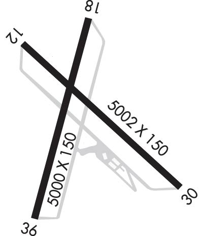
Runway Identifications
Runway Identification: 12/30Length: 5002 ft
Width: 150 ft
Surface: ASPHALT-FAIR CONDITION
Edge lights: High IntensityTreatment: NONE
Weight: PCN 9 /F/D/Y/U
| | Runway: 12 | | Runway: 30 |
| Mag heading: | 119° | Mag heading: | 299° |
| Rwy Slope: | -.08% Down | Rwy Slope: | .08% Up |
| Approach: | ILS | Approach: | |
| Pattern: | Left Traffic | Pattern: | Left Traffic |
| Markings: | PRECISION INSTRUMENT | Markings: | PRECISION INSTRUMENT |
| Marking Condition: | FAIR | Marking Condition: | FAIR |
| Arresting Dev: | | Arresting Dev: | |
| Lat & Long: | N4147.1 W12414.5 | Lat. & Long.: | N4146.5 W12413.7 |
| Elev: | 56.9 ft. MSL | Elev: | 53.0 ft. MSL |
| TCH: | | TCH: | 60 ft. AGL |
| Visual Glide Path: | | Visual Glide Path: | 3.50 degrees |
| Displaced Threshold: | No | Displaced Threshold: | No |
| Touchdown Zone: | YES | Touchdown Zone: | YES |
| Touchdown Elev.: | 60.1 feet | Touchdown Elev.: | 59.1 feet |
| Visual Glide Slope: | | Visual Glide Slope: | 4-BOX VASI ON LEFT SIDE OF RUNWAY |
| RVR Equipment: | | RVR Equipment: | |
| RVV Equipment: | NO | RVV Equipment: | NO |
| Approach Lights: | MALSR - 1,400 foot medium intensity approach lighting system with runway alignment indicator lights | Approach Lights: | |
| REIL: | NO | REIL: | YES |
| Centerline Lights: | NO | Centerline Lights: | NO |
| Touchdown lights: | NO | Touchdown lights: | NO |
| Runway Category: | Precision Instrument Runway | Runway Category: | Runway with a Visual Approach |
| Declared Distances: | TORA:5002' TODA:5002' ASDA:5002' LDA:5002' | Declared Distances: | TORA:5002' TODA:5002' ASDA:5002' LDA:5002' |
| Obstructions: | | Obstructions: | TREES |
| Marked: | | Marked: | NOT Marked/Lighted |
| Clearance slope: | 50:1 | Clearance slope: | 15:1 |
| Obstruction height: | | Obstruction height: | 86 feet AGL |
| Dist. from runway: | | Dist. from runway: | 1520 feet |
| Centerline offset: | | Centerline offset: | 250 feet right of centerline |
| Comments: | | Comments: | |
Runway Identification: 18/36Length: 5000 ft
Width: 150 ft
Surface: ASPHALT-FAIR CONDITION
Edge lights: Medium IntensityTreatment: NONE
Weight: PCN 9 /F/D/Y/U
| | Runway: 18 | | Runway: 36 |
| Mag heading: | 179° | Mag heading: | 359° |
| Rwy Slope: | -.20% Down | Rwy Slope: | .20% Up |
| Approach: | | Approach: | |
| Pattern: | Left Traffic | Pattern: | Left Traffic |
| Markings: | NONPRECISION INSTRUMENT | Markings: | NONPRECISION INSTRUMENT |
| Marking Condition: | FAIR | Marking Condition: | FAIR |
| Arresting Dev: | | Arresting Dev: | |
| Lat & Long: | N4147.2 W12414.2 | Lat. & Long.: | N4146.4 W12414.4 |
| Elev: | 60.6 ft. MSL | Elev: | 50.6 ft. MSL |
| TCH: | | TCH: | 48 ft. AGL |
| Visual Glide Path: | | Visual Glide Path: | 3.00 degrees |
| Displaced Threshold: | 148 feet | Displaced Threshold: | No |
| Touchdown Zone: | YES | Touchdown Zone: | YES |
| Touchdown Elev.: | 60.7 feet | Touchdown Elev.: | 59.2 feet |
| Visual Glide Slope: | | Visual Glide Slope: | 4-BOX VASI ON LEFT SIDE OF RUNWAY |
| RVR Equipment: | | RVR Equipment: | |
| RVV Equipment: | NO | RVV Equipment: | NO |
| Approach Lights: | | Approach Lights: | |
| REIL: | YES | REIL: | YES |
| Centerline Lights: | NO | Centerline Lights: | NO |
| Touchdown lights: | NO | Touchdown lights: | NO |
| Runway Category: | Runway with a Visual Approach | Runway Category: | Runway with a Non-precision Approach having visibility minimums greater than 3/4 mile |
| Declared Distances: | TORA:5000' TODA:5000' ASDA:5000' LDA:4850' | Declared Distances: | TORA:4850' TODA:4850' ASDA:4850' LDA:4850' |
| Obstructions: | GND | Obstructions: | ROAD |
| Marked: | NOT Marked/Lighted | Marked: | NOT Marked/Lighted |
| Clearance slope: | 15:1 | Clearance slope: | 16:1 |
| Obstruction height: | 55 feet AGL | Obstruction height: | 9 feet AGL |
| Dist. from runway: | 1075 feet | Dist. from runway: | 350 feet |
| Centerline offset: | 250 right of centerline | Centerline offset: | |
| Comments: | | Comments: | |

