Click here for more info on on SMS!

KCDR

CHADRON MUNI
CHADRON
NE
Time Zone: Mountain
Lat: N 4250.3
Long: W 10305.7
Elev: 3298
Var: -07
Longest Runway: 5998
AWOS: 118.05
CTAF: 122.8

FBO & Flight Services info for KCDR

FBOs: Update your Fuel Prices
The Chadron Municipal Airport (CDR) is located 5 miles west of Chadron on Highway 20. The airport is owned and operated by the City of Chadron with FBO services provided by J & J Aero Services. Commercial flights are provided by Boutique Air.
Ph: 308-432-0505
-
Freq: 122.8WebsiteE-Mail
Service
Jet
100LL
SAF
MoGas
Fuel Avail: PRIST PREMIXED
Full        Last Update: 04/01/2024 15:04

Self5.745.80    
Misc. Info: Address: 100 AIRPORT RD,   CHADRON, NE 69337

AWOSPh: 308-432-5574
-
Freq: 118.05  
If you are an FBO, call 1-203-262-1700 to update your info or email: FltPlan.Advertising@garmin.com
Advertise your FBO on FltPlan.com

Runway & Approach Info for KCDR
Rwy
Length
Land Dist**
Approach*
  Rwy
Length
Land Dist**
Approach*
03
5998x100  5709'          
ILS
 110.90 - 028°  
  
21
  5998x100  5500'          
 
12
4400x75  4400'          
 
  
30
  4400x75  4400'          
 
 * only ILS, LOC, LDA, and SDF approaches to a specific runway are shown
** For any Declared Landing Distance Available, please see A/FD or Approach plates
Runway Weight Capability (lbs.) Help
Runway IDSingle WheelDouble WheelDouble Tandem WheelDual Double Wheel
03/2130,00055,00090,000N/A
12/3021,00030,000N/AN/A
These numbers are Advisory and are not limits.   The Airport Manager should have more accurate Weight Limits
Approach Charts
Approaches    
Current Weather/Notams
Customs Information Send updates to Support@FltPlan.com
Customs Not Available
Database effective 04/18/2024
Airport Diagram of KCDR
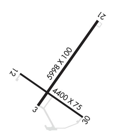
Airport Diagram might not be current.

Facility Name: CHADRON MUNI
City Name: CHADRON
County: DAWES
State abbrev: NE
State Name: NEBRASKA
   
Ownership: PUBLICLY OWNED
Use: OPEN TO THE PUBLIC
Owner's Name: CITY OF CHADRON
Address: P.O. BOX 390
 CHADRON, NE 69337-0390
Owner's Phone: 308-432-0505
  
Manager's Name: MR. TOM MENKE; ROGER STEVENS ON SITE AIRPORT OPERATIONS SUPERVISOR. ARPT OFFICE 308-615-9007
Address: P.O. BOX 390
 CHADRON, NE 69337-0390
Phone: 308-432-0505
   
FAA Region: CENTRAL
FAA Field Office: NONE


Sunrise / Sunset times for CHADRON MUNI

DateSunriseSunset
04/15/24 Monday6:0919:36
04/16/24 Tuesday6:0819:37
04/17/24 Wednesday6:0619:38
04/18/24 Thursday6:0519:39
04/19/24 Friday6:0319:40
04/20/24 Saturday6:0219:41
04/21/24 Sunday6:0019:43
04/22/24 Monday5:5819:44
04/23/24 Tuesday5:5719:45
04/24/24 Wednesday5:5519:46
04/25/24 Thursday5:5419:47
04/26/24 Friday5:5219:48
04/27/24 Saturday5:5119:49
04/28/24 Sunday5:5019:51

Airport Facilities

Airport Attendance Schedule7 Days A Week 0800-1600
Airport Status OPERATIONAL (This Status can change at any time - please check NOTAMS)
Airport Lighting ScheduleACTVT HIRL RY 03/21 & MIRL RY 12/30; REIL RY 21 & RY 30 ; PAPI RYS 12/30; VASI RYS 03/21; MALSR RY 03 - CTAF.
Airport Storage AvailableTie Downs, Hanger
Extra Services AvailableCharter
Wind IndicatorYES - (lighted)
Control TowerNO
CTAF Frequency122.800
Unicom Frequency122.800
Rotating Beacon ColorWG
Segmented CircleYES
Landing FeeNO

Airport Inspection Data

Airport InspectedSTATE - performed by STATE AERONAUTICAL PERSONNEL
Inspection Date08/10/2023

Airport Services

Type of Fuel AvailableGrade 100LL, JET A (freeze point -40C)
Airframe Repair ServiceMAJOR
Power Plant Repair ServiceMAJOR

Geographic Data

LatitudeN4250.3
LongitudeW10305.7 (ESTIMATED)
Arpt Elevation3297ft (SURVEYED)
Magnetic Variation07E
4 miles Wof CHADRON
Traffic Pattern Altitude
Sectional ChartCHEYENNE

Aircraft Data

Operations (Reported)YearlyAvg. Daily
General Aviation Transient 29138
General Aviation Local 23767
Air Taxi 6672
Commerical 12493
Commuter 00
Military 4601
Aircraft based on Field
General Aviation Singles 12
General Aviation Multi 0
Jet Aircraft 0
General Aviation Helicopters 0
Military Aircraft 0
Gliders 0
Ultralights 0

FAA Services

FSS on field NO
FSS tie-in COLUMBUS
FSS Phone 1-800-WX-BRIEF
Who issues Notams CDR
Notam D service at airport YES
ARTCC Name DENVER

Federal Status

Airport Certification
Aircraft Rescue & Firefighting IndexNone
Airport of EntryNo
Custom Landing RightsNo
Joint Civil/MilitaryNo
Military Landing rightsYES

Federal Agreements

NATIONAL PLAN OF INTEGRATED AIRPORT SYSTEMS (NPIAS)
GRANT AGREEMENTS UNDER FAAP/ADAP/AIP
ADVANCE PLANNING AGREEMENT UNDER FAAP
ASSURANCES PURSUANT TO TITLE VI, CIVIL RIGHTS ACT OF 1964

Remarks

FOR CD IF UNA TO CTC ON FSS FREQ, CTC DENVER ARTCC AT 303-651-4257.
Airport Communications & Frequencies:
CTAF Frequency:
122.800
Unicom Frequency:
122.800
Remarks
  • APCH/DEP CTL SVC PRVDD BY DENVER ARTCC (ZDV) ON FREQS 127.95/338.2 (CRAWFORD RCAG).
  • Runway Identifications
    Runway Identification: 03/21
    Length: 5998 ft
    Width: 100 ft
    Surface: CONCRETE
    Edge lights: High Intensity

    Treatment: NONE
    Weight: PCN 12 /R/B/W/T

     Runway: 03   Runway: 21
    Mag heading: 28°Mag heading: 208°
    Rwy Slope: -.49% DownRwy Slope: .49% Up
    Approach: ILSApproach:
    Pattern: Left TrafficPattern: Left Traffic
    Markings: PRECISION INSTRUMENTMarkings: NONPRECISION INSTRUMENT
    Marking Condition: GOODMarking Condition: GOOD
    Arresting Dev: Arresting Dev:
    Lat & Long: N4250.0  W10306.0Lat. & Long.: N4250.8  W10305.2
    Elev: 3297.8 ft. MSLElev: 3268.7 ft. MSL
    TCH: 61 ft. AGLTCH: 41 ft. AGL
    Visual Glide Path: 3.00 degreesVisual Glide Path: 3.00 degrees
    Displaced Threshold: 289 feetDisplaced Threshold: 498 feet
    Touchdown Zone: YESTouchdown Zone: YES
    Touchdown Elev.: 3294.4 feetTouchdown Elev.: 3285.7 feet
    Visual Glide Slope: 4-BOX VASI ON LEFT SIDE OF RUNWAYVisual Glide Slope: 4-BOX VASI ON LEFT SIDE OF RUNWAY
    RVR Equipment: RVR Equipment:
    RVV Equipment: NORVV Equipment: NO
    Approach Lights: MALSR - 1,400 foot medium intensity approach lighting system with runway alignment indicator lightsApproach Lights:
    REIL: NOREIL: YES
    Centerline Lights: NOCenterline Lights: NO
    Touchdown lights: NOTouchdown lights: NO
    Runway Category: Precision Instrument RunwayRunway Category: D
    Declared Distances: TORA:5998' TODA:5998' ASDA:5500' LDA:5211'Declared Distances: TORA:5998' TODA:5998' ASDA:5500' LDA:5500'
    Obstructions: Obstructions: BRUSH
    Marked: Marked: NOT Marked/Lighted
    Clearance slope: 50:1; APCH RATIO 45:1 FM DSPLCD THR.Clearance slope: 9:1
    Obstruction height: Obstruction height: 14 feet AGL
    Dist. from runway: Dist. from runway: 331 feet
    Centerline offset: Centerline offset: 426 feet left of centerline
    Comments: Comments:
    Runway Identification: 12/30
    Length: 4400 ft
    Width: 75 ft
    Surface: CONCRETE
    Edge lights: Medium Intensity

    Treatment: NONE
    Weight: PCN 10 /R/B/W/T

     Runway: 12   Runway: 30
    Mag heading: 118°Mag heading: 298°
    Rwy Slope: -.23% DownRwy Slope: .23% Up
    Approach: Approach:
    Pattern: Left TrafficPattern: Left Traffic
    Markings: NONPRECISION INSTRUMENTMarkings: NONPRECISION INSTRUMENT
    Marking Condition: GOODMarking Condition: GOOD
    Arresting Dev: Arresting Dev:
    Lat & Long: N4250.3  W10306.3Lat. & Long.: N4249.9  W10305.4
    Elev: 3293.7 ft. MSLElev: 3283.7 ft. MSL
    TCH: 29 ft. AGLTCH: 41 ft. AGL
    Visual Glide Path: 3.00 degreesVisual Glide Path: 3.00 degrees
    Displaced Threshold: NoDisplaced Threshold: No
    Touchdown Zone: YESTouchdown Zone: YES
    Touchdown Elev.: 3293.7 feetTouchdown Elev.: 3289.7 feet
    Visual Glide Slope: 4-Light PAPI on LEFT side of RunwayVisual Glide Slope: 4-Light PAPI on LEFT side of Runway
    RVR Equipment: RVR Equipment:
    RVV Equipment: NORVV Equipment: NO
    Approach Lights: Approach Lights:
    REIL: NOREIL: YES
    Centerline Lights: NOCenterline Lights: NO
    Touchdown lights: NOTouchdown lights: NO
    Runway Category: Runway with a Visual ApproachRunway Category: Runway with a Visual Approach
    Declared Distances: TORA:4400' TODA:4400' ASDA:4400' LDA:4400'Declared Distances: TORA:4400' TODA:4400' ASDA:4400' LDA:4400'
    Obstructions: TREESObstructions: ROAD
    Marked: NOT Marked/LightedMarked: NOT Marked/Lighted
    Clearance slope: 49:1Clearance slope: 34:1
    Obstruction height: 15 feet AGLObstruction height: 35 feet AGL
    Dist. from runway: 936 feetDist. from runway: 1400 feet
    Centerline offset: 169 right of centerlineCenterline offset: 220 feet left of centerline
    Comments: Comments:
    C:21/P: