Current Weather/Notams (Metars, TAFs, Notams, NWS Forecast, PIREPS, and nearby weather)
Customs Information Send updates to Support@FltPlan.com
Customs Not Available
Database effective 04/18/2024
Airport Diagram might not be current.
|
| Facility Name: | WOODWARD FLD |
| City Name: | CAMDEN |
| County: | KERSHAW |
| State abbrev: | SC |
| State Name: | SOUTH CAROLINA |
| | |
| Ownership: | PUBLICLY OWNED |
| Use: | OPEN TO THE PUBLIC |
| Owner's Name: | KERSHAW COUNTY |
| Address: | COURTHOUSE, ROOM 202 |
| | CAMDEN, SC 29020 |
| Owner's Phone: | 803-425-1500 |
| | |
| Manager's Name: | MR. GERALD BLANCHARD |
| Address: | 2203 AIRLINE DRIVE |
| | CAMDEN, SC 29020 |
| Phone: | 803-729-0925 |
| | |
| FAA Region: | SOUTHERN |
| FAA Field Office: | ATL |
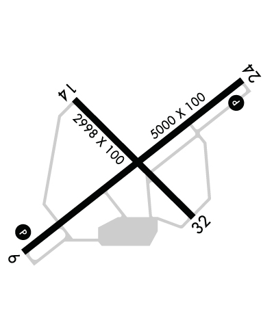
Runway Identifications
Runway Identification: 06/24Length: 5000 ft
Width: 100 ft
Surface: ASPHALT
Edge lights: Medium IntensityTreatment: NONE
Weight: PCN 19 /F/C/X/T
| | Runway: 06 | | Runway: 24 |
| Mag heading: | 57° | Mag heading: | 237° |
| Rwy Slope: | .20% Up | Rwy Slope: | -.20% Down |
| Approach: | | Approach: | |
| Pattern: | Left Traffic | Pattern: | Left Traffic |
| Markings: | NONPRECISION INSTRUMENT | Markings: | NONPRECISION INSTRUMENT |
| Marking Condition: | GOOD | Marking Condition: | GOOD |
| Arresting Dev: | | Arresting Dev: | |
| Lat & Long: | N3416.8 W08034.3 | Lat. & Long.: | N3417.3 W08033.5 |
| Elev: | 286.4 ft. MSL | Elev: | 296.4 ft. MSL |
| TCH: | 31 ft. AGL | TCH: | 28 ft. AGL |
| Visual Glide Path: | 3.00 degrees | Visual Glide Path: | 3.00 degrees |
| Displaced Threshold: | No | Displaced Threshold: | No |
| Touchdown Zone: | YES | Touchdown Zone: | YES |
| Touchdown Elev.: | 302.2 feet | Touchdown Elev.: | 302.2 feet |
| Visual Glide Slope: | 2-Light PAPI on LEFT side of Runway | Visual Glide Slope: | 2-Light PAPI on LEFT side of Runway |
| RVR Equipment: | | RVR Equipment: | |
| RVV Equipment: | NO | RVV Equipment: | NO |
| Approach Lights: | | Approach Lights: | |
| REIL: | YES | REIL: | YES |
| Centerline Lights: | NO | Centerline Lights: | NO |
| Touchdown lights: | NO | Touchdown lights: | NO |
| Runway Category: | Runway with a Non-precision Approach having visibility minimums greater than 3/4 mile | Runway Category: | Runway with a Non-precision Approach having visibility minimums greater than 3/4 mile |
| Declared Distances: | | Declared Distances: | |
| Obstructions: | | Obstructions: | POLE |
| Marked: | | Marked: | NOT Marked/Lighted |
| Clearance slope: | 34:1 | Clearance slope: | 30:1 |
| Obstruction height: | | Obstruction height: | 27 feet AGL |
| Dist. from runway: | | Dist. from runway: | 1024 feet |
| Centerline offset: | | Centerline offset: | 153 feet left of centerline |
| Comments: | | Comments: | |
Runway Identification: 14/32Length: 2998 ft
Width: 100 ft
Surface: ASPHALT-FAIR CONDITION
Edge lights: Treatment: NONE
| | Runway: 14 | | Runway: 32 |
| Mag heading: | 140° | Mag heading: | 320° |
| Rwy Slope: | .05% Up | Rwy Slope: | -.05% Down |
| Approach: | | Approach: | |
| Pattern: | Left Traffic | Pattern: | Left Traffic |
| Markings: | BASIC | Markings: | BASIC |
| Marking Condition: | GOOD | Marking Condition: | GOOD |
| Arresting Dev: | | Arresting Dev: | |
| Lat & Long: | N3417.2 W08034.1 | Lat. & Long.: | N3416.9 W08033.7 |
| Elev: | 298.1 ft. MSL | Elev: | 299.7 ft. MSL |
| TCH: | | TCH: | |
| Visual Glide Path: | | Visual Glide Path: | |
| Displaced Threshold: | No | Displaced Threshold: | No |
| Touchdown Zone: | YES | Touchdown Zone: | YES |
| Touchdown Elev.: | 302.2 feet | Touchdown Elev.: | 302.2 feet |
| Visual Glide Slope: | | Visual Glide Slope: | |
| RVR Equipment: | | RVR Equipment: | |
| RVV Equipment: | NO | RVV Equipment: | NO |
| Approach Lights: | | Approach Lights: | |
| REIL: | NO | REIL: | NO |
| Centerline Lights: | NO | Centerline Lights: | NO |
| Touchdown lights: | NO | Touchdown lights: | NO |
| Runway Category: | Runway with a Visual Approach | Runway Category: | Runway with a Visual Approach |
| Declared Distances: | | Declared Distances: | |
| Obstructions: | TREE | Obstructions: | TREE |
| Marked: | NOT Marked/Lighted | Marked: | NOT Marked/Lighted |
| Clearance slope: | 8:1 | Clearance slope: | 18:1 |
| Obstruction height: | 43 feet AGL | Obstruction height: | 78 feet AGL |
| Dist. from runway: | 581 feet | Dist. from runway: | 1624 feet |
| Centerline offset: | 139 right of centerline | Centerline offset: | 184 feet right of centerline |
| Comments: | | Comments: | |