Click here for more info on on SMS!

KCDI

CAMBRIDGE MUNI
CAMBRIDGE
OH
Time Zone: Eastern
Lat: N 3958.5
Long: W 08134.7
Elev: 799
Var: +07
Longest Runway: 4298
AWOS: 118.52
CTAF: 123.07

FBO & Flight Services info for KCDI

FBOs: Update your Fuel Prices

  click here  
The Cambridge Municipal Airport is located 2 miles from downtown Cambridge. The airport has 2 courtesy cars available for short term use and offers a quiet Pilots lounge with TV for relaxation for pilots while their clients attend meetings, etc. Coffee, cookies and popcorn are also free of charge. Free WIFI available.
Ph: 740-432-3726 Fax: 740-439-2885 Freq: 123.07WebsiteE-Mail
                          
Service
Jet
100LL
SAF
MoGas
Fuel Avail: PRIST + $0.05/gal. Weekdays unattended Sundays call 740-517-0458 or 740-630-4689
Full5.32      Last Update: 04/04/2024 11:25

Self  6.63    
Misc. Info: Address: 9732 BRICK CHURCH RD   CAMBRIDGE, OH 43725

AWOSPh: 740-435-0086
-
Freq: 118.52  
If you are an FBO, call 1-203-262-1700 to update your info or email: FltPlan.Advertising@garmin.com
Advertise your FBO on FltPlan.com

Runway & Approach Info for KCDI
Rwy
Length
Land Dist**
Approach*
  Rwy
Length
Land Dist**
Approach*
04
4298x75  3898'          
 
  
22
  4298x75  4298'          
LOC/DME
 109.35 - 220°  
 * only ILS, LOC, LDA, and SDF approaches to a specific runway are shown
** For any Declared Landing Distance Available, please see A/FD or Approach plates
Runway Weight Capability (lbs.) Help
Runway IDSingle WheelDouble WheelDouble Tandem WheelDual Double Wheel
04/2224,000N/AN/AN/A
These numbers are Advisory and are not limits.   The Airport Manager should have more accurate Weight Limits
Approach Charts
Approaches    
Current Weather/Notams
Customs Information Send updates to Support@FltPlan.com
Customs Not Available
Database effective 04/18/2024
Airport Diagram of KCDI
Airport Diagram might not be current.

Facility Name: CAMBRIDGE MUNI
City Name: CAMBRIDGE
County: GUERNSEY
State abbrev: OH
State Name: OHIO
   
Ownership: PUBLICLY OWNED
Use: OPEN TO THE PUBLIC
Owner's Name: CAMBRIDGE AREA RGNL ARPT AUTH; CDIAIRPORT@GMAIL.COM.
Address: PO BOX 73
 CAMBRIDGE, OH 43725-0073
Owner's Phone: 740-432-3726
  
Manager's Name: TERRY LOSEGO; OPSMANAGER@CAMBRIDGEOHIOAIRPORT.COM.
Address: 9732 BRICK CHURCH RD
 CAMBRIDGE, OH 43725-9420
Phone: 740-517-0458; OPS MGR.
   
FAA Region: GREAT LAKES
FAA Field Office: DET
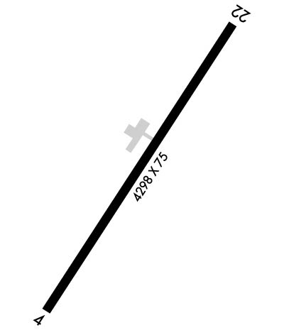

Sunrise / Sunset times for CAMBRIDGE MUNI

DateSunriseSunset
04/17/24 Wednesday6:4420:08
04/18/24 Thursday6:4320:09
04/19/24 Friday6:4220:10
04/20/24 Saturday6:4020:11
04/21/24 Sunday6:3920:12
04/22/24 Monday6:3720:13
04/23/24 Tuesday6:3620:14
04/24/24 Wednesday6:3520:15
04/25/24 Thursday6:3320:16
04/26/24 Friday6:3220:17
04/27/24 Saturday6:3120:18
04/28/24 Sunday6:2920:19
04/29/24 Monday6:2820:20
04/30/24 Tuesday6:2720:21

Airport Facilities

Airport Attendance ScheduleMON-SAT 0800-1700
Airport Status OPERATIONAL (This Status can change at any time - please check NOTAMS)
Airport Lighting ScheduleACTVT REIL RWY 04 & 22; MIRL RWY 04/22 - CTAF. PAPI RWY 04 & 22 OPR CONSLY.
Airport Storage AvailableTie Downs, Hanger
Extra Services AvailableNONE
Wind IndicatorYES - (lighted)
Control TowerNO
CTAF Frequency123.075
Unicom Frequency123.075
Rotating Beacon ColorWG
Segmented CircleYES
Landing FeeNO

Airport Inspection Data

Airport InspectedSTATE - performed by STATE AERONAUTICAL PERSONNEL
Inspection Date06/03/2022

Airport Services

Type of Fuel AvailableGrade 100LL, JET A; -10SELF SVC.
Airframe Repair ServiceNONE
Power Plant Repair ServiceNONE

Geographic Data

LatitudeN3958.5
LongitudeW08134.7 (ESTIMATED)
Arpt Elevation798ft (SURVEYED)
Magnetic Variation07W
3 miles Sof CAMBRIDGE
Traffic Pattern Altitude
Sectional ChartCINCINNATI

Aircraft Data

Operations (Reported)YearlyAvg. Daily
General Aviation Transient 5001
General Aviation Local 3461
Air Taxi 4771
Commerical 00
Commuter 00
Military 380
Aircraft based on Field
General Aviation Singles 11
General Aviation Multi 0
Jet Aircraft 0
General Aviation Helicopters 2
Military Aircraft 0
Gliders 0
Ultralights 2

FAA Services

FSS on field NO
FSS tie-in CLEVELAND
FSS Phone 1-800-WX-BRIEF
Who issues Notams CDI
Notam D service at airport YES
ARTCC Name CLEVELAND

Federal Status

Airport Certification
Aircraft Rescue & Firefighting IndexNone
Airport of EntryNo
Custom Landing RightsNo
Joint Civil/MilitaryNo
Military Landing rightsYES

Federal Agreements

NATIONAL PLAN OF INTEGRATED AIRPORT SYSTEMS (NPIAS)
GRANT AGREEMENTS UNDER FAAP/ADAP/AIP
ASSURANCES PURSUANT TO TITLE VI, CIVIL RIGHTS ACT OF 1964

Remarks

THIS AIRPORT HAS BEEN SURVEYED BY THE NATIONAL GEODETIC SURVEY.
DEER, BIRDS, & OTR WILDLIFE INVOF ARPT.
RAMP FEES FOR COML ACFT EXC FLT TRG ACFT, CDI BASED ACFT, OVNGT HNGR STAY, FUEL PURCHASE OF 25 GALS OR TOP OFF.
FOR CD CTC CLEVELAND ARTCC AT 440-774-0226/0490.
RWY 04 OBSTN LGTD HILLS SW OF ARPT.
Airport Communications & Frequencies:
CTAF Frequency:
123.075
Unicom Frequency:
123.075
Remarks
  • APCH/DEP SVC PRVDD BY INDIANAPOLIS ARTCC (ZID) ON FREQS 124.45/323.275 (ZANESVILLE RCAG) WEST SIDE OPS.
  • APCH/DEP SVC PRVDD BY CLEVELAND ARTCC (ZOB) ON FREQS 126.95/239.3 (BELMONT RCAG) EAST SIDE OPS.
  • Runway Identifications
    Runway Identification: 04/22
    Length: 4298 ft
    Width: 75 ft
    Surface: ASPHALT-GOOD CONDITION
    Edge lights: Medium Intensity

    Treatment: GROOVED

     Runway: 04   Runway: 22
    Mag heading: 40°Mag heading: 220°
    Rwy Slope: .00%Rwy Slope: .00%
    Approach: Approach: LOC/DME
    Pattern: Left TrafficPattern: Left Traffic
    Markings: NONPRECISION INSTRUMENTMarkings: NONPRECISION INSTRUMENT
    Marking Condition: GOODMarking Condition: GOOD
    Arresting Dev: Arresting Dev:
    Lat & Long: N3958.2  W08134.9Lat. & Long.: N3958.8  W08134.4
    Elev: 798.5 ft. MSLElev: 798.5 ft. MSL
    TCH: 29 ft. AGLTCH: 28 ft. AGL
    Visual Glide Path: 4.00 degreesVisual Glide Path: 3.55 degrees
    Displaced Threshold: 400 feetDisplaced Threshold: No
    Touchdown Zone: YESTouchdown Zone: YES
    Touchdown Elev.: 798.7 feetTouchdown Elev.: 798.8 feet
    Visual Glide Slope: 4-Light PAPI on LEFT side of Runway; PAPI UNUSBL BYD 4 DEGS LEFT & 8 DEGS RIGHT OF CNTRLN.Visual Glide Slope: 4-Light PAPI on RIGHT side of Runway; PAPI UNUSBL BYD 8 DEGS LEFT & 4 DEGS RIGHT OF CNTRLN.
    RVR Equipment: RVR Equipment:
    RVV Equipment: NORVV Equipment: NO
    Approach Lights: Approach Lights:
    REIL: YESREIL: YES
    Centerline Lights: NOCenterline Lights: NO
    Touchdown lights: NOTouchdown lights: NO
    Runway Category: Runway with a Non-precision ApproachRunway Category: Runway with a Non-precision Approach
    Declared Distances: Declared Distances:
    Obstructions: PLINEObstructions: ROAD
    Marked: NOT Marked/LightedMarked: NOT Marked/Lighted
    Clearance slope: 11:1; APCH SLP 11:1 DUE TO 61 FT TREE, 692 FT FM DTHR, 61 FT L.Clearance slope: 10:1
    Obstruction height: 50 feet AGLObstruction height: 15 feet AGL
    Dist. from runway: 795 feetDist. from runway: 355 feet
    Centerline offset: 205 left of centerlineCenterline offset: 270 feet left of centerline
    Comments: Comments:
    C:2/P: