Current Weather/Notams (Metars, TAFs, Notams, NWS Forecast, PIREPS, and nearby weather)
Customs Information Send updates to Support@FltPlan.com
Customs Not Available
Database effective 05/16/2024
Airport Diagram might not be current.
|
| Facility Name: | NORTHEAST IOWA RGNL |
| City Name: | CHARLES CITY |
| County: | FLOYD |
| State abbrev: | IA |
| State Name: | IOWA |
| | |
| Ownership: | PUBLICLY OWNED |
| Use: | OPEN TO THE PUBLIC |
| Owner's Name: | NORTH CEDAR AVIATION AUTHORITY; JEFF SISSON, CHAIRMAN |
| Address: | 3131 HWY 18 E |
| | CHARLES CITY, IA 50616 |
| Owner's Phone: | 641-228-3553 |
| | |
| Manager's Name: | WILLIAM R KYLE |
| Address: | 3129 HWY 18 |
| | CHARLES CITY, IA 50616 |
| Phone: | 641-228-3553 |
| | |
| FAA Region: | CENTRAL |
| FAA Field Office: | NONE |
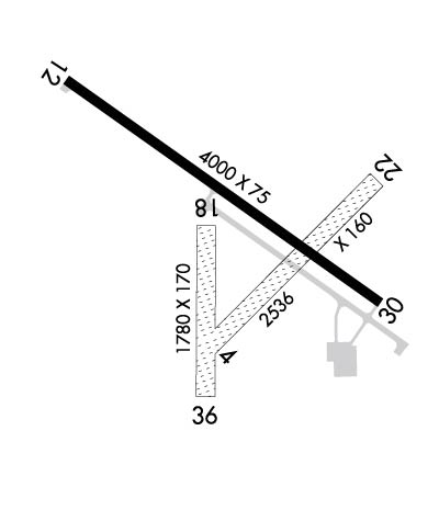
Runway Identifications
Runway Identification: 04/22Length: 2536 ft
Width: 160 ft
Surface: GRASS-GOOD CONDITION
Edge lights: Treatment: NONE
| | Runway: 04 | | Runway: 22 |
| Mag heading: | 45° | Mag heading: | 225° |
| Rwy Slope: | .08% Up | Rwy Slope: | -.08% Down |
| Approach: | | Approach: | |
| Pattern: | Left Traffic | Pattern: | Left Traffic |
| Markings: | | Markings: | |
| Marking Condition: | THLDS & EDGES MKD WITH YELLOW CONES. | Marking Condition: | THLDS & EDGES MKD WITH YELLOW CONES. |
| Arresting Dev: | | Arresting Dev: | |
| Lat & Long: | N4304.2 W09236.7 | Lat. & Long.: | N4304.5 W09236.3 |
| Elev: | 1122.7 ft. MSL | Elev: | 1124.8 ft. MSL |
| TCH: | | TCH: | |
| Visual Glide Path: | | Visual Glide Path: | |
| Displaced Threshold: | No | Displaced Threshold: | No |
| Touchdown Zone: | YES | Touchdown Zone: | YES |
| Touchdown Elev.: | 1124.8 feet | Touchdown Elev.: | 1124.8 feet |
| Visual Glide Slope: | | Visual Glide Slope: | |
| RVR Equipment: | | RVR Equipment: | |
| RVV Equipment: | NO | RVV Equipment: | NO |
| Approach Lights: | | Approach Lights: | |
| REIL: | NO | REIL: | NO |
| Centerline Lights: | NO | Centerline Lights: | NO |
| Touchdown lights: | NO | Touchdown lights: | NO |
| Runway Category: | Runway with a Visual Approach | Runway Category: | Runway with a Visual Approach |
| Declared Distances: | | Declared Distances: | |
| Obstructions: | PLINE | Obstructions: | FENCE |
| Marked: | NOT Marked/Lighted | Marked: | NOT Marked/Lighted |
| Clearance slope: | 40:1 | Clearance slope: | 20:1 |
| Obstruction height: | 25 feet AGL | Obstruction height: | 4 feet AGL |
| Dist. from runway: | 1000 feet | Dist. from runway: | 80 feet |
| Centerline offset: | | Centerline offset: | 80 feet right of centerline |
| Comments: | | Comments: | |
Runway Identification: 12/30Length: 4000 ft
Width: 75 ft
Surface: CONCRETE-GOOD CONDITION
Edge lights: Medium IntensityTreatment: NONE
Weight: PCN 7 /R/C/W/U
| | Runway: 12 | | Runway: 30 |
| Mag heading: | 125° | Mag heading: | 305° |
| Rwy Slope: | .00% Down | Rwy Slope: | .00% Up |
| Approach: | LOCALIZER | Approach: | |
| Pattern: | Left Traffic | Pattern: | Left Traffic |
| Markings: | NONPRECISION INSTRUMENT | Markings: | NONPRECISION INSTRUMENT |
| Marking Condition: | FAIR | Marking Condition: | FAIR |
| Arresting Dev: | | Arresting Dev: | |
| Lat & Long: | N4304.6 W09237.1 | Lat. & Long.: | N4304.2 W09236.3 |
| Elev: | 1116.7 ft. MSL | Elev: | 1116.6 ft. MSL |
| TCH: | 26 ft. AGL | TCH: | 27 ft. AGL |
| Visual Glide Path: | 3.00 degrees | Visual Glide Path: | 3.00 degrees |
| Displaced Threshold: | No | Displaced Threshold: | No |
| Touchdown Zone: | YES | Touchdown Zone: | YES |
| Touchdown Elev.: | 1120.9 feet | Touchdown Elev.: | 1120.9 feet |
| Visual Glide Slope: | 2-Light PAPI on LEFT side of Runway | Visual Glide Slope: | 2-Light PAPI on LEFT side of Runway |
| RVR Equipment: | | RVR Equipment: | |
| RVV Equipment: | NO | RVV Equipment: | NO |
| Approach Lights: | | Approach Lights: | |
| REIL: | YES | REIL: | YES |
| Centerline Lights: | NO | Centerline Lights: | NO |
| Touchdown lights: | NO | Touchdown lights: | NO |
| Runway Category: | Runway with a Non-precision Approach having visibility minimums greater than 3/4 mile | Runway Category: | Runway with a Non-precision Approach having visibility minimums greater than 3/4 mile |
| Declared Distances: | | Declared Distances: | |
| Obstructions: | | Obstructions: | TREE |
| Marked: | | Marked: | NOT Marked/Lighted |
| Clearance slope: | 34:1 | Clearance slope: | 16:1 |
| Obstruction height: | | Obstruction height: | 57 feet AGL |
| Dist. from runway: | | Dist. from runway: | 1158 feet |
| Centerline offset: | | Centerline offset: | 385 feet left of centerline |
| Comments: | | Comments: | |
Runway Identification: 18/36Length: 1780 ft
Width: 170 ft
Surface: GRASS-GOOD CONDITION
Edge lights: Treatment: NONE
| | Runway: 18 | | Runway: 36 |
| Mag heading: | 180° | Mag heading: | 0° |
| Rwy Slope: | .07% Up | Rwy Slope: | -.07% Down |
| Approach: | | Approach: | |
| Pattern: | Left Traffic | Pattern: | Left Traffic |
| Markings: | | Markings: | |
| Marking Condition: | THLDS & EDGES MKD WITH YELLOW CONES. | Marking Condition: | THLDS & EDGES MKD WITH YELLOW CONES. |
| Arresting Dev: | | Arresting Dev: | |
| Lat & Long: | N4304.4 W09236.7 | Lat. & Long.: | N4304.1 W09236.7 |
| Elev: | 1121.0 ft. MSL | Elev: | 1122.2 ft. MSL |
| TCH: | | TCH: | |
| Visual Glide Path: | | Visual Glide Path: | |
| Displaced Threshold: | No | Displaced Threshold: | No |
| Touchdown Zone: | YES | Touchdown Zone: | YES |
| Touchdown Elev.: | 1122.2 feet | Touchdown Elev.: | 1122.2 feet |
| Visual Glide Slope: | | Visual Glide Slope: | |
| RVR Equipment: | | RVR Equipment: | |
| RVV Equipment: | NO | RVV Equipment: | NO |
| Approach Lights: | | Approach Lights: | |
| REIL: | NO | REIL: | NO |
| Centerline Lights: | NO | Centerline Lights: | NO |
| Touchdown lights: | NO | Touchdown lights: | NO |
| Runway Category: | Runway with a Visual Approach | Runway Category: | Runway with a Visual Approach |
| Declared Distances: | | Declared Distances: | |
| Obstructions: | TREE | Obstructions: | ROAD |
| Marked: | NOT Marked/Lighted | Marked: | NOT Marked/Lighted |
| Clearance slope: | 24:1 | Clearance slope: | 30:1 |
| Obstruction height: | 24 feet AGL | Obstruction height: | 10 feet AGL |
| Dist. from runway: | 596 feet | Dist. from runway: | 300 feet |
| Centerline offset: | 174 left of centerline | Centerline offset: | |
| Comments: | | Comments: | |

