Click here for more info on on SMS!

KCCO

NEWNAN COWETA COUNTY
ATLANTA
GA
Time Zone: Eastern
Lat: N 3318.7
Long: W 08446.2
Elev: 970
Var: +03
Longest Runway: 5500
Clr Del: 119.8
AWOS: 118.97
CTAF: 122.7

FBO & Flight Services info for KCCO

FBOs: Update your Fuel Prices

  click here  
Oasis Aviation is a full-service avionics and maintenance provider focused on Garmin avionics installation and service. As a Platinum Garmin Avionics dealership, we specialize in complete retrofits Including radar, flight displays and autopilots. We also offer avionics from other major brands, general aviation maintenance, and routine inspections and services. Call 678-870-3085 for more info.
Ph: 678-870-3085 Fax: 866-870-0805
-
WebsiteE-Mail
                   
Service
Jet
100LL
SAF
MoGas
Fuel Avail: NO FUEL AVAILABLE
Full        Last Update: 04/19/2024 00:01:45

Self        
Misc. Info: AVIONICS SERVICES ONLY.Address: 52 DALE PEPPER DRIVE,   NEWNAN, GA 30263

CCO AIRPORT SVCSPh: 770-254-8102 Fax: 770-683-3472 Freq: 122.70
Service
Jet
100LL
SAF
MoGas
Fuel Avail: PRIST Premixed. PRICES INCLUDE TAX
Full5.205.59    Last Update: 04/05/2024 12:17  
Self  4.99    
 Address: 115 AIRPORT RD BOX 2   NEWNAN, GA 30263
AWOSPh: 770-254-1617
-
Freq: 118.97  
If you are an FBO, call 1-203-262-1700 to update your info or email: FltPlan.Advertising@garmin.com
Advertise your FBO on FltPlan.com

Runway & Approach Info for KCCO
Rwy
Length
Land Dist**
Approach*
  Rwy
Length
Land Dist**
Approach*
15
5500x100  5500'          
 
  
33
  5500x100  5500'          
LOC/GS
 110.75 - 322°  
 * only ILS, LOC, LDA, and SDF approaches to a specific runway are shown
** For any Declared Landing Distance Available, please see A/FD or Approach plates
Runway Weight Capability (lbs.) Help
Runway IDSingle WheelDouble WheelDouble Tandem WheelDual Double Wheel
15/3326,00037,000N/AN/A
These numbers are Advisory and are not limits.   The Airport Manager should have more accurate Weight Limits
Approach Charts
Approaches    
Current Weather/Notams
Customs Information Send updates to Support@FltPlan.com
Customs Not Available
Database effective 04/18/2024
Airport Diagram of KCCO
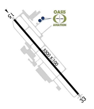
Airport Diagram might not be current.

Facility Name: NEWNAN COWETA COUNTY
City Name: ATLANTA
County: COWETA
State abbrev: GA
State Name: GEORGIA
   
Ownership: PUBLICLY OWNED
Use: OPEN TO THE PUBLIC
Owner's Name: NEWNAN & COWETA CO ARPT AUTH
Address: 115 AIRPORT ROAD, BOX 2
 NEWNAN, GA 30263
Owner's Phone: 770-254-8102
  
Manager's Name: CALVIN WALKER
Address: 115 AIRPORT ROAD, BOX 2
 NEWNAN, GA 30263
Phone: 770-254-8102
   
FAA Region: SOUTHERN
FAA Field Office: ATL


Sunrise / Sunset times for NEWNAN COWETA COUNTY

DateSunriseSunset
04/18/24 Thursday7:0420:13
04/19/24 Friday7:0320:13
04/20/24 Saturday7:0220:14
04/21/24 Sunday7:0120:15
04/22/24 Monday7:0020:16
04/23/24 Tuesday6:5920:16
04/24/24 Wednesday6:5820:17
04/25/24 Thursday6:5720:18
04/26/24 Friday6:5520:19
04/27/24 Saturday6:5420:19
04/28/24 Sunday6:5320:20
04/29/24 Monday6:5220:21
04/30/24 Tuesday6:5120:22
05/01/24 Wednesday6:5020:22

Airport Facilities

Airport Attendance ScheduleM-F 0700-2000, S-S 0800-1800
Airport Status OPERATIONAL (This Status can change at any time - please check NOTAMS)
Airport Lighting ScheduleACTVT MALSF RWY 33; HIRL RWY 15/33 - CTAF.
Airport Storage AvailableTie Downs
Extra Services AvailableAir Ambulance, Flight Instruction, Aircraft Rental
Wind IndicatorYES - (lighted)
Control TowerNO
CTAF Frequency122.700
Unicom Frequency122.700
Rotating Beacon ColorWG
Segmented CircleYES
Landing FeeNO

Airport Inspection Data

Airport InspectedSTATE - performed by STATE AERONAUTICAL PERSONNEL
Inspection Date03/31/2023

Airport Services

Type of Fuel AvailableGrade 100LL, JET A
Airframe Repair ServiceMAJOR
Power Plant Repair ServiceMAJOR

Geographic Data

LatitudeN3318.7
LongitudeW08446.2 (ESTIMATED)
Arpt Elevation970ft (SURVEYED)
Magnetic Variation03W
4 miles Sof ATLANTA
Traffic Pattern Altitude
Sectional ChartATLANTA

Aircraft Data

Operations (Reported)YearlyAvg. Daily
General Aviation Transient 2000055
General Aviation Local 3000082
Air Taxi 00
Commerical 00
Commuter 00
Military 00
Aircraft based on Field
General Aviation Singles 125
General Aviation Multi 9
Jet Aircraft 7
General Aviation Helicopters 3
Military Aircraft 0
Gliders 0
Ultralights 0

FAA Services

FSS on field NO
FSS tie-in MACON
FSS Phone 1-800-WX-BRIEF
Who issues Notams MCN
Notam D service at airport YES
ARTCC Name ATLANTA

Federal Status

Airport Certification
Aircraft Rescue & Firefighting IndexNone
Airport of EntryNo
Custom Landing RightsNo
Joint Civil/MilitaryNo
Military Landing rightsYES

Federal Agreements

NATIONAL PLAN OF INTEGRATED AIRPORT SYSTEMS (NPIAS)
GRANT AGREEMENTS UNDER FAAP/ADAP/AIP
ASSURANCES PURSUANT TO TITLE VI, CIVIL RIGHTS ACT OF 1964

Remarks

GCO AVBL ON FREQ 121.725 THRU FLT SVCS.
WILDLIFE INVOF ARPT.
EXTENSIVE FLIGHT TRAINING ON AND INVOF AIRPORT
FOR CD CTC ATLANTA APCH AT 678-364-6131.
Airport Communications & Frequencies:
CTAF Frequency:
122.700
Unicom Frequency:
122.700
ATLANTA Primary Approach Frequencies:  
119.8
354.125
ATLANTA Primary Departure Frequencies:  
119.8
354.125
Runway Identifications
Runway Identification: 15/33
Length: 5500 ft
Width: 100 ft
Surface: ASPHALT-FAIR CONDITION
Edge lights: High Intensity

Treatment: NONE

 Runway: 15   Runway: 33
Mag heading: 142°Mag heading: 322°
Rwy Slope: -.75% DownRwy Slope: .75% Up
Approach: Approach: LOC/GS
Pattern: Left TrafficPattern: Left Traffic
Markings: PRECISION INSTRUMENTMarkings: PRECISION INSTRUMENT
Marking Condition: GOODMarking Condition: GOOD
Arresting Dev: Arresting Dev:
Lat & Long: N3319.0  W08446.5Lat. & Long.: N3318.3  W08445.8
Elev: 970.2 ft. MSLElev: 928.9 ft. MSL
TCH: 40 ft. AGLTCH: 49 ft. AGL
Visual Glide Path: 3.00 degreesVisual Glide Path: 3.00 degrees
Displaced Threshold: NoDisplaced Threshold: No
Touchdown Zone: YESTouchdown Zone: YES
Touchdown Elev.: 970.2 feetTouchdown Elev.: 952.1 feet
Visual Glide Slope: 4-Light PAPI on LEFT side of RunwayVisual Glide Slope: 4-Light PAPI on LEFT side of Runway
RVR Equipment: RVR Equipment:
RVV Equipment: NORVV Equipment: NO
Approach Lights: Approach Lights: MALSF - 1,400 foot medium intensity approach lighting system with sequenced flashers
REIL: NOREIL: NO
Centerline Lights: NOCenterline Lights: NO
Touchdown lights: NOTouchdown lights: NO
Runway Category: Runway with a Non-precision Approach having visibility minimums greater than 3/4 mileRunway Category: Precision Instrument Runway
Declared Distances: Declared Distances:
Obstructions: TREESObstructions: TREES
Marked: NOT Marked/LightedMarked: NOT Marked/Lighted
Clearance slope: 11:1Clearance slope:
Obstruction height: 64 feet AGLObstruction height: 30 feet AGL
Dist. from runway: 927 feetDist. from runway: 201 feet
Centerline offset: 582 left of centerlineCenterline offset: 264 feet right of centerline
Comments: 15 FT POWER POLES, 139 FT FROM EOR, 355 FT RIGHT OF CNTRLN.Comments: 30 FT TREES, 264 FT RIGHT OF CNTRLN AT RWY END OUT TO 200 FT FM RWY END.
C:16/P: