| |||||||||||||||||||||||||||||||||||||||||||||||||||||||||||||
| |||||||||||||||||||||||||||||||||||||||||||||||||||||||||||||
| Rwy | Rwy | |||||||
| 3863x75 | 3757' | 3863x75 | 3706' | |||||
| Runway ID | Single Wheel | Double Wheel | Double Tandem Wheel | Dual Double Wheel |
| 06/24 | 20,000 | N/A | N/A | N/A |
| H1 | N/A | N/A | N/A | N/A |
| H2 | N/A | N/A | N/A | N/A |
| These numbers are Advisory and are not limits. The Airport Manager should have more accurate Weight Limits | ||||
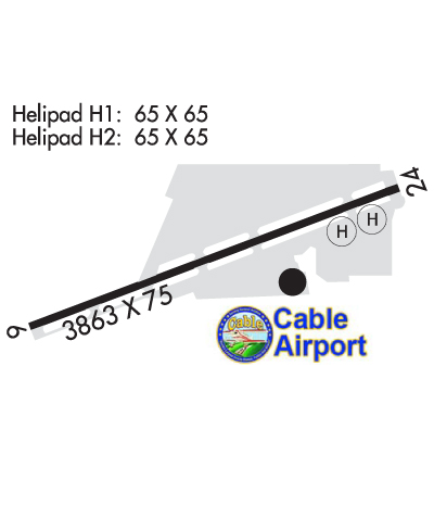 Airport Diagram might not be current. | |
| Facility Name: | CABLE |
| City Name: | UPLAND |
| County: | SAN BERNARDINO |
| State abbrev: | CA |
| State Name: | CALIFORNIA |
| Ownership: | PRIVATELY OWNED |
| Use: | OPEN TO THE PUBLIC |
| Owner's Name: | CABLE LAND CO - A PARTNERSHIP |
| Address: | 1749 WEST 13TH STREET |
| UPLAND, CA 91786-2199 | |
| Owner's Phone: | 909-982-6021 |
| Manager's Name: | STEPHEN DUNN |
| Address: | 1749 WEST 13TH STREET |
| UPLAND, CA 91786-2199 | |
| Phone: | 951-315-9224 |
| FAA Region: | WESTERN-PACIFIC |
| FAA Field Office: | LAX |
| Date | Sunrise | Sunset |
|---|---|---|
| 04/23/24 Tuesday | 6:09 | 19:29 |
| 04/24/24 Wednesday | 6:08 | 19:30 |
| 04/25/24 Thursday | 6:07 | 19:31 |
| 04/26/24 Friday | 6:06 | 19:32 |
| 04/27/24 Saturday | 6:05 | 19:32 |
| 04/28/24 Sunday | 6:04 | 19:33 |
| 04/29/24 Monday | 6:03 | 19:34 |
| 04/30/24 Tuesday | 6:02 | 19:35 |
| 05/01/24 Wednesday | 6:01 | 19:35 |
| 05/02/24 Thursday | 6:00 | 19:36 |
| 05/03/24 Friday | 5:59 | 19:37 |
| 05/04/24 Saturday | 5:58 | 19:38 |
| 05/05/24 Sunday | 5:57 | 19:39 |
| 05/06/24 Monday | 5:56 | 19:39 |
| Airport Attendance Schedule | 7 Days A Week DALGT |
| Airport Status | OPERATIONAL (This Status can change at any time - please check NOTAMS) |
| Airport Lighting Schedule | ACTVT HELIPAD H1 PERIMETER LGTS - CTAF. MIRL RWY 06/24 PRESET ON LOW INTST SS-SR ACTVT HIGH INTST - CTAF. |
| Airport Storage Available | Tie Downs |
| Extra Services Available | Avionics, Flight Instruction, Aircraft Rental, Aircraft Sales |
| Wind Indicator | YES - (lighted) |
| Control Tower | NO |
| CTAF Frequency | 123.000 |
| Unicom Frequency | 123.000 |
| Rotating Beacon Color | WG |
| Segmented Circle | NO |
| Landing Fee | NO |
| Airport Inspected | STATE - performed by STATE AERONAUTICAL PERSONNEL |
| Inspection Date | 06/21/2023 |
| Type of Fuel Available | Grade 100LL, JET A (freeze point -40C); -10SELF SERVICE 24 HOUR |
| Airframe Repair Service | MAJOR |
| Power Plant Repair Service | MAJOR |
| Latitude | N3406.7 |
| Longitude | W11741.2 (ESTIMATED) |
| Arpt Elevation | 1443ft (SURVEYED) |
| Magnetic Variation | 14E |
| 2 miles NW | of UPLAND |
| Traffic Pattern Altitude | 800 |
| Sectional Chart | LOS ANGELES |
| Operations (Reported) | Yearly | Avg. Daily |
|---|---|---|
| General Aviation Transient | 18438 | 51 |
| General Aviation Local | 73751 | 202 |
| Air Taxi | 0 | 0 |
| Commerical | 0 | 0 |
| Commuter | 0 | 0 |
| Military | 0 | 0 |
| Aircraft based on Field | |
|---|---|
| General Aviation Singles | 230 |
| General Aviation Multi | 9 |
| Jet Aircraft | 0 |
| General Aviation Helicopters | 2 |
| Military Aircraft | 0 |
| Gliders | 4 |
| Ultralights | 0 |
| FSS on field | NO |
| FSS tie-in | RIVERSIDE |
| FSS Phone | 1-800-WX-BRIEF |
| Who issues Notams | RAL |
| Notam D service at airport | YES |
| ARTCC Name | LOS ANGELES |
| Airport Certification | |
| Aircraft Rescue & Firefighting Index | None |
| Airport of Entry | No |
| Custom Landing Rights | No |
| Joint Civil/Military | No |
| Military Landing rights | YES |
| NATIONAL PLAN OF INTEGRATED AIRPORT SYSTEMS (NPIAS) |
| ASSURANCES PURSUANT TO TITLE VI, CIVIL RIGHTS ACT OF 1964 |
| FOR CD CTC SOCAL APCH AT 800-448-3724. |
| RWY 06/2 4 GROSS PAVEMENT STRENGTH PRVDD BY ARPT OPERATOR 12500 LBS. |
Airport Communications & Frequencies:
| ||||||||||||||
| Runway: 06 | Runway: 24 | ||
| Mag heading: | 55° | Mag heading: | 235° |
| Rwy Slope: | 1.31% Up | Rwy Slope: | -1.31% Down |
| Approach: | Approach: | ||
| Pattern: | Left Traffic | Pattern: | Left Traffic |
| Markings: | NONPRECISION INSTRUMENT | Markings: | BASIC |
| Marking Condition: | GOOD | Marking Condition: | GOOD |
| Arresting Dev: | Arresting Dev: | ||
| Lat & Long: | N3406.6 W11741.6 | Lat. & Long.: | N3406.8 W11740.9 |
| Elev: | 1393.0 ft. MSL | Elev: | 1443.5 ft. MSL |
| TCH: | 34 ft. AGL | TCH: | 24 ft. AGL |
| Visual Glide Path: | 4.00 degrees | Visual Glide Path: | 4.00 degrees |
| Displaced Threshold: | 106 feet | Displaced Threshold: | 157 feet |
| Touchdown Zone: | YES | Touchdown Zone: | YES |
| Touchdown Elev.: | 1429.9 feet | Touchdown Elev.: | 1440.4 feet |
| Visual Glide Slope: | 2-Box VASI on LEFT side of Runway | Visual Glide Slope: | 2-Box VASI on RIGHT side of Runway; UNUSBL BYD 5 DEG LEFT AND 2 DEG RIGHT OF RWY CNTRLN. |
| RVR Equipment: | RVR Equipment: | ||
| RVV Equipment: | NO | RVV Equipment: | NO |
| Approach Lights: | Approach Lights: | ||
| REIL: | NO | REIL: | NO |
| Centerline Lights: | NO | Centerline Lights: | NO |
| Touchdown lights: | NO | Touchdown lights: | NO |
| Runway Category: | Runway with a Non-precision Approach having visibility minimums greater than 3/4 mile | Runway Category: | Runway with a Visual Approach |
| Declared Distances: | Declared Distances: | ||
| Obstructions: | Obstructions: | ROAD | |
| Marked: | Marked: | NOT Marked/Lighted | |
| Clearance slope: | 34:1 | Clearance slope: | APCH RATIO TO DSPLCD THR OVER +9 FT ROAD 220 FT FROM DSPLCD THR; 24:1. |
| Obstruction height: | Obstruction height: | 9 feet AGL | |
| Dist. from runway: | Dist. from runway: | 200 feet | |
| Centerline offset: | Centerline offset: | ||
| Comments: | Comments: | +6 FT FENCE WITH RED LGTS 50 FT FROM THLD. |