Current Weather/Notams (Metars, TAFs, Notams, NWS Forecast, PIREPS, and nearby weather)
Customs Information Send updates to Support@FltPlan.com
Customs Not Available
Database effective 04/18/2024
Airport Diagram might not be current.
|
| Facility Name: | SHALZ FLD |
| City Name: | COLBY |
| County: | THOMAS |
| State abbrev: | KS |
| State Name: | KANSAS |
| | |
| Ownership: | PUBLICLY OWNED |
| Use: | OPEN TO THE PUBLIC |
| Owner's Name: | CITY OF COLBY |
| Address: | 585 N. FRANKLIN |
| | COLBY, KS 67701 |
| Owner's Phone: | 785-460-4438 |
| | |
| Manager's Name: | MARK OSTMEYER |
| Address: | 5 ARPT PLAZZA |
| | COLBY, KS 67701 |
| Phone: | 785-460-4438 |
| | |
| FAA Region: | CENTRAL |
| FAA Field Office: | NONE |
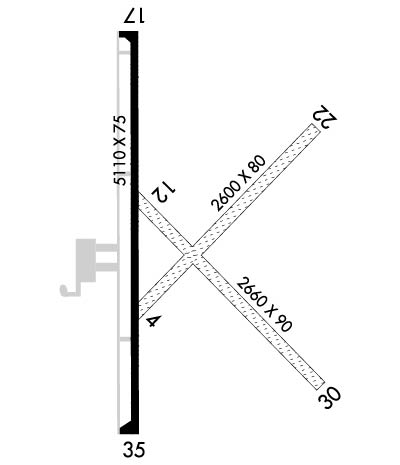
Runway Identifications
Runway Identification: 04/22Length: 2600 ft
Width: 80 ft
Surface: GRASS-GOOD CONDITION
Edge lights: Treatment: NONE
| | Runway: 04 | | Runway: 22 |
| Mag heading: | 38° | Mag heading: | 218° |
| Rwy Slope: | .32% Up | Rwy Slope: | -.32% Down |
| Approach: | | Approach: | |
| Pattern: | Left Traffic | Pattern: | Left Traffic |
| Markings: | | Markings: | |
| Marking Condition: | | Marking Condition: | |
| Arresting Dev: | | Arresting Dev: | |
| Lat & Long: | N3925.5 W10102.9 | Lat. & Long.: | N3925.8 W10102.5 |
| Elev: | 3162.3 ft. MSL | Elev: | 3170.7 ft. MSL |
| TCH: | | TCH: | |
| Visual Glide Path: | | Visual Glide Path: | |
| Displaced Threshold: | No | Displaced Threshold: | No |
| Touchdown Zone: | YES | Touchdown Zone: | YES |
| Touchdown Elev.: | 3170.7 feet | Touchdown Elev.: | 3170.7 feet |
| Visual Glide Slope: | | Visual Glide Slope: | |
| RVR Equipment: | | RVR Equipment: | |
| RVV Equipment: | NO | RVV Equipment: | NO |
| Approach Lights: | | Approach Lights: | |
| REIL: | NO | REIL: | NO |
| Centerline Lights: | NO | Centerline Lights: | NO |
| Touchdown lights: | NO | Touchdown lights: | NO |
| Runway Category: | Runway with a Visual Approach | Runway Category: | Runway with a Visual Approach |
| Declared Distances: | | Declared Distances: | |
Runway Identification: 12/30Length: 2660 ft
Width: 90 ft
Surface: GRASS-GOOD CONDITION
Edge lights: Treatment: NONE
| | Runway: 12 | | Runway: 30 |
| Mag heading: | 127° | Mag heading: | 307° |
| Rwy Slope: | -.65% Down | Rwy Slope: | .65% Up |
| Approach: | | Approach: | |
| Pattern: | Left Traffic | Pattern: | Left Traffic |
| Markings: | | Markings: | |
| Marking Condition: | | Marking Condition: | |
| Arresting Dev: | | Arresting Dev: | |
| Lat & Long: | N3925.7 W10102.9 | Lat. & Long.: | N3925.4 W10102.5 |
| Elev: | 3170.2 ft. MSL | Elev: | 3152.8 ft. MSL |
| TCH: | | TCH: | |
| Visual Glide Path: | | Visual Glide Path: | |
| Displaced Threshold: | No | Displaced Threshold: | No |
| Touchdown Zone: | YES | Touchdown Zone: | YES |
| Touchdown Elev.: | 3170.2 feet | Touchdown Elev.: | 3170.2 feet |
| Visual Glide Slope: | | Visual Glide Slope: | |
| RVR Equipment: | | RVR Equipment: | |
| RVV Equipment: | NO | RVV Equipment: | NO |
| Approach Lights: | | Approach Lights: | |
| REIL: | NO | REIL: | NO |
| Centerline Lights: | NO | Centerline Lights: | NO |
| Touchdown lights: | NO | Touchdown lights: | NO |
| Runway Category: | Runway with a Visual Approach | Runway Category: | Runway with a Visual Approach |
| Declared Distances: | | Declared Distances: | |
Runway Identification: 17/35Length: 5110 ft
Width: 75 ft
Surface: CONCRETE-FAIR CONDITION
Edge lights: Medium IntensityTreatment: AGGREGATE FRICTION SEAL COAT
| | Runway: 17 | | Runway: 35 |
| Mag heading: | 172° | Mag heading: | 352° |
| Rwy Slope: | -.65% Down | Rwy Slope: | .65% Up |
| Approach: | | Approach: | |
| Pattern: | Left Traffic | Pattern: | Left Traffic |
| Markings: | NONPRECISION INSTRUMENT | Markings: | NONPRECISION INSTRUMENT |
| Marking Condition: | FAIR; RY 17/35 MARKINGS SLIGHTLY FADED. | Marking Condition: | FAIR |
| Arresting Dev: | | Arresting Dev: | |
| Lat & Long: | N3926.1 W10102.9 | Lat. & Long.: | N3925.3 W10102.9 |
| Elev: | 3188.2 ft. MSL | Elev: | 3155.1 ft. MSL |
| TCH: | 40 ft. AGL | TCH: | 48 ft. AGL |
| Visual Glide Path: | 3.00 degrees | Visual Glide Path: | 3.00 degrees |
| Displaced Threshold: | No | Displaced Threshold: | No |
| Touchdown Zone: | YES | Touchdown Zone: | YES |
| Touchdown Elev.: | 3188.2 feet | Touchdown Elev.: | 3176.1 feet |
| Visual Glide Slope: | 4-Light PAPI on LEFT side of Runway | Visual Glide Slope: | 4-Light PAPI on LEFT side of Runway |
| RVR Equipment: | | RVR Equipment: | |
| RVV Equipment: | NO | RVV Equipment: | NO |
| Approach Lights: | | Approach Lights: | |
| REIL: | YES | REIL: | YES |
| Centerline Lights: | NO | Centerline Lights: | NO |
| Touchdown lights: | NO | Touchdown lights: | NO |
| Runway Category: | Runway with a Non-precision Approach having visibility minimums greater than 3/4 mile | Runway Category: | Runway with a Non-precision Approach having visibility minimums greater than 3/4 mile |
| Declared Distances: | | Declared Distances: | |
| Obstructions: | | Obstructions: | TREE |
| Marked: | | Marked: | NOT Marked/Lighted |
| Clearance slope: | 50:1 | Clearance slope: | 16:1 |
| Obstruction height: | | Obstruction height: | 60 feet AGL |
| Dist. from runway: | | Dist. from runway: | 1181 feet |
| Centerline offset: | | Centerline offset: | 683 feet left of centerline |
| Comments: | | Comments: | |
