Click here for more info on on SMS!

KCAV

CLARION MUNI
CLARION
IA
Time Zone: Central
Lat: N 4244.4
Long: W 09345.5
Elev: 1157
Var: -03
Longest Runway: 3455
AWOS: 126.57
CTAF: 122.8

FBO & Flight Services info for KCAV

FBOs: Update your Fuel Prices

CLARION MUNICIPALPh: 515-532-6980
-
Freq: 122.8
Service
Jet
100LL
SAF
MoGas
Fuel Avail: ~~Availability of Services Is Unknown
Full        Last Update: 04/19/2024 00:01:44

Self        
 Address: 2074 210TH ST   CLARION, IA 50525
AWOSPh: 515-532-3515
-
Freq: 126.57  
If you are an FBO, call 1-203-262-1700 to update your info or email: FltPlan.Advertising@garmin.com
Advertise your FBO on FltPlan.com

Runway & Approach Info for KCAV
Rwy
Length
Land Dist**
Approach*
  Rwy
Length
Land Dist**
Approach*
14
3455x60  3455'          
 
  
32
  3455x60  3455'          
 
 * only ILS, LOC, LDA, and SDF approaches to a specific runway are shown
** For any Declared Landing Distance Available, please see A/FD or Approach plates
Runway Weight Capability (lbs.) Help
Runway IDSingle WheelDouble WheelDouble Tandem WheelDual Double Wheel
14/3217,000N/AN/AN/A
These numbers are Advisory and are not limits.   The Airport Manager should have more accurate Weight Limits
Approach Charts
Approaches    
Current Weather/Notams
Customs Information Send updates to Support@FltPlan.com
Customs Not Available
Database effective 04/18/2024
Airport Diagram of KCAV
Airport Diagram might not be current.

Facility Name: CLARION MUNI
City Name: CLARION
County: WRIGHT
State abbrev: IA
State Name: IOWA
   
Ownership: PUBLICLY OWNED
Use: OPEN TO THE PUBLIC
Owner's Name: CITY OF CLARION
Address: 121 1ST ST. SW
 CLARION, IA 50525
Owner's Phone: 515-851-0526
  
Manager's Name: JON DEVRIES
Address: 2076 - 210TH STREET
 CLARION, IA 50525
Phone: 515-532-6980
   
FAA Region: CENTRAL
FAA Field Office: NONE


Sunrise / Sunset times for CLARION MUNI

DateSunriseSunset
04/19/24 Friday6:2620:03
04/20/24 Saturday6:2420:04
04/21/24 Sunday6:2320:05
04/22/24 Monday6:2120:06
04/23/24 Tuesday6:2020:07
04/24/24 Wednesday6:1820:08
04/25/24 Thursday6:1720:10
04/26/24 Friday6:1520:11
04/27/24 Saturday6:1420:12
04/28/24 Sunday6:1220:13
04/29/24 Monday6:1120:14
04/30/24 Tuesday6:1020:15
05/01/24 Wednesday6:0820:16
05/02/24 Thursday6:0720:17

Airport Facilities

Airport Attendance ScheduleUNATTENDED
Airport Status OPERATIONAL (This Status can change at any time - please check NOTAMS)
Airport Lighting ScheduleRY 14/32 MIRL PRESET LOW INTST; ACTVT PAPI & REIL RY 14 & 32 & MIRL RY 14/32 HIGHER INTST - CTAF
Airport Storage AvailableTie Downs, Hanger
Extra Services AvailableNONE
Wind IndicatorYES - (lighted)
Control TowerNO
CTAF Frequency122.800
Unicom Frequency122.800
Rotating Beacon ColorWG
Segmented CircleNO
Landing FeeNO

Airport Inspection Data

Airport InspectedSTATE - performed by STATE AERONAUTICAL PERSONNEL
Inspection Date07/06/2023

Airport Services

Type of Fuel AvailableGrade 100LL, JET A (freeze point -40C)
Airframe Repair ServiceNONE
Power Plant Repair ServiceNONE

Geographic Data

LatitudeN4244.4
LongitudeW09345.5 (ESTIMATED)
Arpt Elevation1156ft (SURVEYED)
Magnetic Variation03E
1 miles NWof CLARION
Traffic Pattern Altitude
Sectional ChartOMAHA

Aircraft Data

Operations (Reported)YearlyAvg. Daily
General Aviation Transient 20996
General Aviation Local 14014
Air Taxi 00
Commerical 00
Commuter 00
Military 00
Aircraft based on Field
General Aviation Singles 11
General Aviation Multi 3
Jet Aircraft 0
General Aviation Helicopters 0
Military Aircraft 0
Gliders 0
Ultralights 0

FAA Services

FSS on field NO
FSS tie-in FORT DODGE
FSS Phone 1-800-WX-BRIEF
Who issues Notams CAV
Notam D service at airport YES
ARTCC Name MINNEAPOLIS

Federal Status

Airport Certification
Aircraft Rescue & Firefighting IndexNone
Airport of EntryNo
Custom Landing RightsNo
Joint Civil/MilitaryNo
Military Landing rightsYES

Federal Agreements

NATIONAL PLAN OF INTEGRATED AIRPORT SYSTEMS (NPIAS)
ASSURANCES PURSUANT TO TITLE VI, CIVIL RIGHTS ACT OF 1964
GRANT AGREEMENT HAS EXPIRED; HOWEVER, AGREEMENT REMAINS IN EFFECT FOR THIS FACILITY AS LONG AS IT IS PUBLIC USE.

Remarks

FOR CD CTC MINNEAPOLIS ARTCC AT 651-463-5588.
Airport Communications & Frequencies:
CTAF Frequency:
122.800
Unicom Frequency:
122.800
Remarks
  • APCH/DEP SVC PRVDD BY MINNEAPOLIS ARTCC ON FREQS 134.0/288.3 (FORT DODGE RCAG).
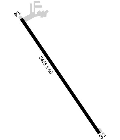
  • Runway Identifications
    Runway Identification: 14/32
    Length: 3455 ft
    Width: 60 ft
    Surface: CONCRETE-GOOD CONDITION
    Edge lights: Medium Intensity

    Treatment: NONE
    Weight: PCN 8 /R/D/W/U

     Runway: 14   Runway: 32
    Mag heading: 143°Mag heading: 323°
    Rwy Slope: .10% UpRwy Slope: -.10% Down
    Approach: Approach:
    Pattern: Left TrafficPattern: Left Traffic
    Markings: NONPRECISION INSTRUMENTMarkings: NONPRECISION INSTRUMENT
    Marking Condition: GOODMarking Condition: GOOD
    Arresting Dev: Arresting Dev:
    Lat & Long: N4244.7  W09345.8Lat. & Long.: N4244.2  W09345.3
    Elev: 1153.1 ft. MSLElev: 1156.6 ft. MSL
    TCH: 40 ft. AGLTCH: 43 ft. AGL
    Visual Glide Path: 3.00 degreesVisual Glide Path: 3.00 degrees
    Displaced Threshold: NoDisplaced Threshold: No
    Touchdown Zone: YESTouchdown Zone: YES
    Touchdown Elev.: 1155.0 feetTouchdown Elev.: 1156.6 feet
    Visual Glide Slope: 2-Light PAPI on LEFT side of RunwayVisual Glide Slope: 2-Light PAPI on LEFT side of Runway
    RVR Equipment: RVR Equipment:
    RVV Equipment: NORVV Equipment: NO
    Approach Lights: Approach Lights:
    REIL: YESREIL: YES
    Centerline Lights: NOCenterline Lights: NO
    Touchdown lights: NOTouchdown lights: NO
    Runway Category: Runway with a Non-precision ApproachRunway Category: Runway with a Visual Approach
    Declared Distances: Declared Distances:
    Obstructions: ROADObstructions: POLE
    Marked: NOT Marked/LightedMarked: NOT Marked/Lighted
    Clearance slope: 20:1Clearance slope: 34:1
    Obstruction height: 18 feet AGLObstruction height: 59 feet AGL
    Dist. from runway: 560 feetDist. from runway: 2210 feet
    Centerline offset: 280 left of centerlineCenterline offset:
    Comments: Comments:
    C:/P: