Current Weather/Notams (Metars, TAFs, Notams, NWS Forecast, PIREPS, and nearby weather)
Customs Information Send updates to Support@FltPlan.com
Customs Not Available
Database effective 04/18/2024
Airport Diagram might not be current.
|
| Facility Name: | CARIBOU MUNI |
| City Name: | CARIBOU |
| County: | AROOSTOOK |
| State abbrev: | ME |
| State Name: | MAINE |
| | |
| Ownership: | PUBLICLY OWNED |
| Use: | OPEN TO THE PUBLIC |
| Owner's Name: | CITY OF CARIBOU |
| Address: | 25 HIGH STREET |
| | CARIBOU, ME 04736 |
| Owner's Phone: | 207-493-3324 |
| | |
| Manager's Name: | DAVE QUELLETTE |
| Address: | 25 HIGH STREET |
| | CARIBOU, ME 04736 |
| Phone: | 207-493-3324 |
| | |
| FAA Region: | NEW ENGLAND |
| FAA Field Office: | NONE |
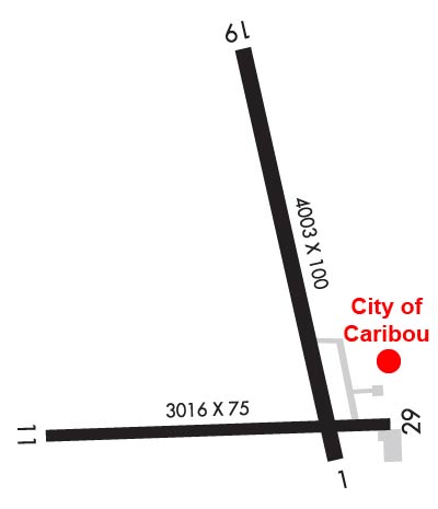
Runway Identifications
Runway Identification: 01/19Length: 4003 ft
Width: 100 ft
Surface: ASPHALT-GOOD CONDITION
Edge lights: Medium IntensityTreatment: NONE
| | Runway: 01 | | Runway: 19 |
| Mag heading: | 4° | Mag heading: | 184° |
| Rwy Slope: | .08% Up | Rwy Slope: | -.08% Down |
| Approach: | | Approach: | |
| Pattern: | Left Traffic | Pattern: | Left Traffic |
| Markings: | NONPRECISION INSTRUMENT | Markings: | NONPRECISION INSTRUMENT |
| Marking Condition: | FAIR | Marking Condition: | FAIR |
| Arresting Dev: | | Arresting Dev: | |
| Lat & Long: | N4652.1 W06800.9 | Lat. & Long.: | N4652.7 W06801.1 |
| Elev: | 614.1 ft. MSL | Elev: | 617.3 ft. MSL |
| TCH: | | TCH: | |
| Visual Glide Path: | | Visual Glide Path: | |
| Displaced Threshold: | No | Displaced Threshold: | No |
| Touchdown Zone: | YES | Touchdown Zone: | YES |
| Touchdown Elev.: | 620.1 feet | Touchdown Elev.: | 620.1 feet |
| Visual Glide Slope: | | Visual Glide Slope: | |
| RVR Equipment: | | RVR Equipment: | |
| RVV Equipment: | NO | RVV Equipment: | NO |
| Approach Lights: | | Approach Lights: | |
| REIL: | NO | REIL: | NO |
| Centerline Lights: | NO | Centerline Lights: | NO |
| Touchdown lights: | NO | Touchdown lights: | NO |
| Runway Category: | Runway with a Visual Approach | Runway Category: | Runway with a Non-precision Approach having visibility minimums greater than 3/4 mile |
| Declared Distances: | | Declared Distances: | |
| Obstructions: | GND | Obstructions: | |
| Marked: | NOT Marked/Lighted | Marked: | |
| Clearance slope: | 1:1 | Clearance slope: | 50:1 |
| Obstruction height: | 7 feet AGL | Obstruction height: | |
| Dist. from runway: | 201 feet | Dist. from runway: | |
| Centerline offset: | 149 right of centerline | Centerline offset: | |
| Comments: | GND 0-200 FT FM EOR 100-250 FT R OF CNTRLN RISING TO +8 FT. | Comments: | |
Runway Identification: 11/29Length: 3016 ft
Width: 75 ft
Surface: ASPHALT-FAIR CONDITION
Edge lights: Medium IntensityTreatment: NONE
| | Runway: 11 | | Runway: 29 |
| Mag heading: | 105° | Mag heading: | 285° |
| Rwy Slope: | -.02% Down | Rwy Slope: | .02% Up |
| Approach: | | Approach: | |
| Pattern: | Left Traffic | Pattern: | Left Traffic |
| Markings: | BASIC | Markings: | BASIC |
| Marking Condition: | GOOD | Marking Condition: | GOOD |
| Arresting Dev: | | Arresting Dev: | |
| Lat & Long: | N4652.1 W06801.6 | Lat. & Long.: | N4652.2 W06800.8 |
| Elev: | 620.0 ft. MSL | Elev: | 619.3 ft. MSL |
| TCH: | | TCH: | |
| Visual Glide Path: | | Visual Glide Path: | |
| Displaced Threshold: | No | Displaced Threshold: | 398 feet |
| Touchdown Zone: | YES | Touchdown Zone: | YES |
| Touchdown Elev.: | 620.3 feet | Touchdown Elev.: | 620.3 feet |
| Visual Glide Slope: | | Visual Glide Slope: | |
| RVR Equipment: | | RVR Equipment: | |
| RVV Equipment: | NO | RVV Equipment: | NO |
| Approach Lights: | | Approach Lights: | |
| REIL: | NO | REIL: | NO |
| Centerline Lights: | NO | Centerline Lights: | NO |
| Touchdown lights: | NO | Touchdown lights: | NO |
| Runway Category: | Runway with a Visual Approach | Runway Category: | Runway with a Visual Approach; 524 FT DTHR; +302 FT BLAST PAD BYD END OF RWY. |
| Declared Distances: | | Declared Distances: | |
| Obstructions: | | Obstructions: | BLDG |
| Marked: | | Marked: | LIGHTED |
| Clearance slope: | 50:1 | Clearance slope: | 5:1; 24:1 RATIO TO DTHR. |
| Obstruction height: | | Obstruction height: | 34 feet AGL |
| Dist. from runway: | | Dist. from runway: | 398 feet |
| Centerline offset: | | Centerline offset: | 95 feet right of centerline |
| Comments: | | Comments: | GND ON BOTH SIDES RISING TO +3 FT 200 FT FM RWY END. |