Current Weather/Notams (Metars, TAFs, Notams, NWS Forecast, PIREPS, and nearby weather)
Customs Information Send updates to Support@FltPlan.com
Customs Not Available
Database effective 05/16/2024
Airport Diagram might not be current.
|
| Facility Name: | DOWAGIAC MUNI |
| City Name: | DOWAGIAC |
| County: | CASS |
| State abbrev: | MI |
| State Name: | MICHIGAN |
| | |
| Ownership: | PUBLICLY OWNED |
| Use: | OPEN TO THE PUBLIC |
| Owner's Name: | CITY OF DOWAGIAC |
| Address: | 241 S. FRONT ST., 241 S FRONT ST |
| | DOWAGIAC, MI 49047-1738 |
| Owner's Phone: | 269-782-8530 |
| | |
| Manager's Name: | OSCAR AZEVEDO |
| Address: | 241 S. FRONT ST., 241 S FRONT ST |
| | DOWAGIAC, MI 49047-1738 |
| Phone: | 269-591-0054 |
| | |
| FAA Region: | GREAT LAKES |
| FAA Field Office: | DET |
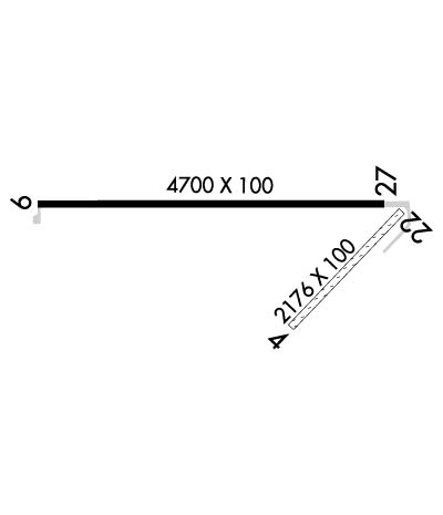
Runway Identifications
Runway Identification: 04/22Length: 2176 ft
Width: 100 ft
Surface: GRASS-FAIR CONDITION
Edge lights: Treatment: NONE
| | Runway: 04 | | Runway: 22 |
| Mag heading: | 49° | Mag heading: | 229° |
| Rwy Slope: | .22% Up | Rwy Slope: | -.22% Down |
| Approach: | | Approach: | |
| Pattern: | Left Traffic | Pattern: | Right Traffic |
| Markings: | BASIC | Markings: | BASIC |
| Marking Condition: | GOOD; RWY 04/22 & RWY 22 DSPLCD THR MKD WITH 3 FT YELLOW CONES. | Marking Condition: | GOOD |
| Arresting Dev: | | Arresting Dev: | |
| Lat & Long: | N4159.3 W08607.6 | Lat. & Long.: | N4159.6 W08607.3 |
| Elev: | 742.0 ft. MSL | Elev: | 746.8 ft. MSL |
| TCH: | | TCH: | |
| Visual Glide Path: | | Visual Glide Path: | |
| Displaced Threshold: | No | Displaced Threshold: | 388 feet |
| Touchdown Zone: | YES | Touchdown Zone: | YES |
| Touchdown Elev.: | 747.3 feet | Touchdown Elev.: | 747.3 feet |
| Visual Glide Slope: | | Visual Glide Slope: | |
| RVR Equipment: | | RVR Equipment: | |
| RVV Equipment: | NO | RVV Equipment: | NO |
| Approach Lights: | | Approach Lights: | |
| REIL: | NO | REIL: | NO |
| Centerline Lights: | NO | Centerline Lights: | NO |
| Touchdown lights: | NO | Touchdown lights: | NO |
| Runway Category: | Runway with a Visual Approach | Runway Category: | Runway with a Visual Approach |
| Declared Distances: | | Declared Distances: | |
| Obstructions: | TREES | Obstructions: | TREE |
| Marked: | NOT Marked/Lighted | Marked: | NOT Marked/Lighted |
| Clearance slope: | 13:1 | Clearance slope: | 13:1; APCH RATIO 20:1 AT DSLPD THR. |
| Obstruction height: | 88 feet AGL | Obstruction height: | 72 feet AGL |
| Dist. from runway: | 1159 feet | Dist. from runway: | 950 feet |
| Centerline offset: | 109 left of centerline | Centerline offset: | 60 feet right of centerline |
| Comments: | | Comments: | |
Runway Identification: 09/27Length: 4700 ft
Width: 100 ft
Surface: ASPHALT-GOOD CONDITION
Edge lights: Medium IntensityTreatment: NONE
| | Runway: 09 | | Runway: 27 |
| Mag heading: | 95° | Mag heading: | 275° |
| Rwy Slope: | .23% Up | Rwy Slope: | -.23% Down |
| Approach: | | Approach: | |
| Pattern: | Left Traffic | Pattern: | Right Traffic |
| Markings: | NONPRECISION INSTRUMENT | Markings: | NONPRECISION INSTRUMENT |
| Marking Condition: | GOOD | Marking Condition: | GOOD |
| Arresting Dev: | | Arresting Dev: | |
| Lat & Long: | N4159.6 W08608.3 | Lat. & Long.: | N4159.6 W08607.3 |
| Elev: | 735.8 ft. MSL | Elev: | 746.7 ft. MSL |
| TCH: | 35 ft. AGL | TCH: | 35 ft. AGL |
| Visual Glide Path: | 3.00 degrees | Visual Glide Path: | 3.00 degrees |
| Displaced Threshold: | No | Displaced Threshold: | No |
| Touchdown Zone: | YES | Touchdown Zone: | YES |
| Touchdown Elev.: | 740.1 feet | Touchdown Elev.: | 746.7 feet |
| Visual Glide Slope: | 4-Light PAPI on LEFT side of Runway | Visual Glide Slope: | 4-Light PAPI on LEFT side of Runway |
| RVR Equipment: | | RVR Equipment: | |
| RVV Equipment: | NO | RVV Equipment: | NO |
| Approach Lights: | | Approach Lights: | |
| REIL: | YES | REIL: | YES |
| Centerline Lights: | NO | Centerline Lights: | NO |
| Touchdown lights: | NO | Touchdown lights: | NO |
| Runway Category: | Runway with a Non-precision Approach | Runway Category: | Runway with a Non-precision Approach |
| Declared Distances: | | Declared Distances: | |
| Obstructions: | CROPS | Obstructions: | TREES |
| Marked: | NOT Marked/Lighted | Marked: | NOT Marked/Lighted |
| Clearance slope: | 3:1 | Clearance slope: | 14:1 |
| Obstruction height: | 9 feet AGL | Obstruction height: | 55 feet AGL |
| Dist. from runway: | 231 feet | Dist. from runway: | 982 feet |
| Centerline offset: | 250 right of centerline | Centerline offset: | 170 feet right of centerline |
| Comments: | +2 FT CROPS, 2 FT TALL, 75 DIST, 250 L & R. | Comments: | |

