Approach Charts
| FltPlan does not have IFR approach charts available for KC59. |
Current Weather/Notams (Metars, TAFs, Notams, NWS Forecast, PIREPS, and nearby weather)
Customs Information Send updates to Support@FltPlan.com
Customs Not Available
Database effective 05/16/2024
Airport Diagram might not be current.
|
| Facility Name: | LAKE LAWN |
| City Name: | DELAVAN |
| County: | WALWORTH |
| State abbrev: | WI |
| State Name: | WISCONSIN |
| | |
| Ownership: | PRIVATELY OWNED |
| Use: | OPEN TO THE PUBLIC |
| Owner's Name: | DELEVAN LAKE LAWN MANAGEMENT |
| Address: | 2400 EAST GENEVA ST |
| | DELAVAN, WI 53115 |
| Owner's Phone: | 262-728-7950 |
| | |
| Manager's Name: | DANIEL LYNG |
| Address: | 2400 EAST GENEVA ST |
| | DELAVAN, WI 53115 |
| Phone: | (262) 725-9127 |
| | |
| FAA Region: | GREAT LAKES |
| FAA Field Office: | CHI |
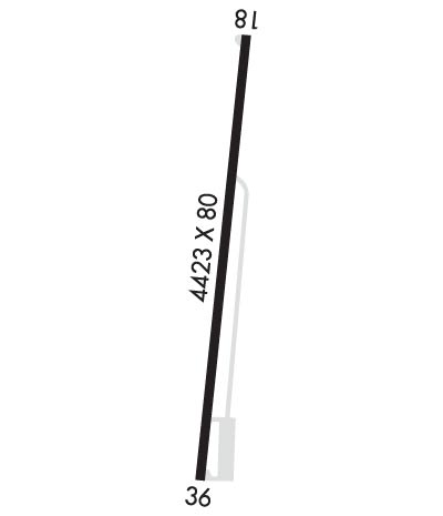
Runway Identifications
Runway Identification: 18/36Length: 4423 ft
Width: 80 ft
Surface: ASPHALT-FAIR CONDITION
Edge lights: Treatment: NONE
| | Runway: 18 | | Runway: 36 |
| Mag heading: | 187° | Mag heading: | 7° |
| Rwy Slope: | -.27% Down | Rwy Slope: | .27% Up |
| Approach: | | Approach: | |
| Pattern: | Left Traffic | Pattern: | Left Traffic |
| Markings: | NONPRECISION INSTRUMENT | Markings: | NONPRECISION INSTRUMENT |
| Marking Condition: | POOR; MARKINGS FADED. | Marking Condition: | POOR; MARKINGS FADED. |
| Arresting Dev: | | Arresting Dev: | |
| Lat & Long: | N4238.4 W08836.0 | Lat. & Long.: | N4237.7 W08836.1 |
| Elev: | 979.0 ft. MSL | Elev: | 967.0 ft. MSL |
| TCH: | | TCH: | |
| Visual Glide Path: | | Visual Glide Path: | |
| Displaced Threshold: | 320 feet | Displaced Threshold: | 300 feet |
| Touchdown Zone: | YES | Touchdown Zone: | YES |
| Touchdown Elev.: | 978.1 feet | Touchdown Elev.: | 981.0 feet |
| Visual Glide Slope: | | Visual Glide Slope: | |
| RVR Equipment: | | RVR Equipment: | |
| RVV Equipment: | NO | RVV Equipment: | NO |
| Approach Lights: | | Approach Lights: | |
| REIL: | NO | REIL: | NO |
| Centerline Lights: | NO | Centerline Lights: | NO |
| Touchdown lights: | NO | Touchdown lights: | NO |
| Runway Category: | Runway with a Visual Approach | Runway Category: | Runway with a Visual Approach |
| Declared Distances: | | Declared Distances: | |
| Obstructions: | TREE | Obstructions: | TREE |
| Marked: | NOT Marked/Lighted | Marked: | NOT Marked/Lighted |
| Clearance slope: | 2:1; APCH RATIO 20:1 TO DSPLCD THR. | Clearance slope: | 8:1; APCH RATIO 20:1 TO DSPLCD THR. |
| Obstruction height: | 17 feet AGL | Obstruction height: | 31 feet AGL |
| Dist. from runway: | 242 feet | Dist. from runway: | 465 feet |
| Centerline offset: | 120 right of centerline | Centerline offset: | 34 feet right of centerline |
| Comments: | 4 FT FENCE 12 FT FM RWY END; RD 40 FT FM RWY END. | Comments: | 4 FT FENCE 5 FT FM RWY END; RD 30 FT FM RWY END. |

