Current Weather/Notams (Metars, TAFs, Notams, NWS Forecast, PIREPS, and nearby weather)
Customs Information Send updates to Support@FltPlan.com
Customs Not Available
Database effective 04/18/2024
Airport Diagram might not be current.
|
| Facility Name: | PORTAGE MUNI |
| City Name: | PORTAGE |
| County: | COLUMBIA |
| State abbrev: | WI |
| State Name: | WISCONSIN |
| | |
| Ownership: | PUBLICLY OWNED |
| Use: | OPEN TO THE PUBLIC |
| Owner's Name: | CITY OF PORTAGE |
| Address: | 115 PLEASANT |
| | PORTAGE, WI 53901 |
| Owner's Phone: | 608-742-2176 |
| | |
| Manager's Name: | PAUL PHELPS |
| Address: | 1011 SILVER LAKE DRIVE, BOX 319 |
| | PORTAGE, WI 53901 |
| Phone: | 608-692-9337; ADDNL PHONE 608-745-9050. |
| | |
| FAA Region: | GREAT LAKES |
| FAA Field Office: | CHI |
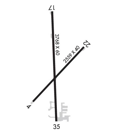
Runway Identifications
Runway Identification: 04/22Length: 2668 ft
Width: 40 ft
Surface: ASPHALT-FAIR CONDITION
Edge lights: Treatment: AGGREGATE FRICTION SEAL COAT
| | Runway: 04 | | Runway: 22 |
| Mag heading: | 46° | Mag heading: | 226° |
| Rwy Slope: | -.33% Down | Rwy Slope: | .33% Up |
| Approach: | | Approach: | |
| Pattern: | Left Traffic | Pattern: | Left Traffic |
| Markings: | BASIC | Markings: | BASIC |
| Marking Condition: | GOOD | Marking Condition: | GOOD |
| Arresting Dev: | | Arresting Dev: | |
| Lat & Long: | N4333.4 W08929.2 | Lat. & Long.: | N4333.7 W08928.8 |
| Elev: | 824.7 ft. MSL | Elev: | 815.8 ft. MSL |
| TCH: | | TCH: | |
| Visual Glide Path: | | Visual Glide Path: | |
| Displaced Threshold: | 109 feet | Displaced Threshold: | No |
| Touchdown Zone: | YES | Touchdown Zone: | YES |
| Touchdown Elev.: | 824.1 feet | Touchdown Elev.: | 824.8 feet |
| Visual Glide Slope: | | Visual Glide Slope: | |
| RVR Equipment: | | RVR Equipment: | |
| RVV Equipment: | NO | RVV Equipment: | NO |
| Approach Lights: | | Approach Lights: | |
| REIL: | NO | REIL: | NO |
| Centerline Lights: | NO | Centerline Lights: | NO |
| Touchdown lights: | NO | Touchdown lights: | NO |
| Runway Category: | Runway with a Visual Approach | Runway Category: | Runway with a Visual Approach |
| Declared Distances: | | Declared Distances: | |
| Obstructions: | ROAD | Obstructions: | TREES |
| Marked: | NOT Marked/Lighted | Marked: | NOT Marked/Lighted |
| Clearance slope: | CTLG OBSTN EXCEEDS A 45 DEG SLP. | Clearance slope: | 10:1 |
| Obstruction height: | 15 feet AGL | Obstruction height: | 58 feet AGL |
| Dist. from runway: | 200 feet | Dist. from runway: | 814 feet |
| Centerline offset: | 80 right of centerline | Centerline offset: | 164 feet left of centerline |
| Comments: | 30 FT TREES 40 FT FM RWY END; 100 FT L. | Comments: | 6 FT TRRN AT THR; 90 FT L. |
Runway Identification: 18/36Length: 3770 ft
Width: 60 ft
Surface: ASPHALT-GOOD CONDITION
Edge lights: Non-Standard Lighting SystemTreatment: NONE
| | Runway: 18 | | Runway: 36 |
| Mag heading: | 181° | Mag heading: | 1° |
| Rwy Slope: | .28% Up | Rwy Slope: | -.28% Down |
| Approach: | | Approach: | |
| Pattern: | Left Traffic | Pattern: | Left Traffic |
| Markings: | NONPRECISION INSTRUMENT | Markings: | NONPRECISION INSTRUMENT |
| Marking Condition: | GOOD | Marking Condition: | GOOD |
| Arresting Dev: | | Arresting Dev: | |
| Lat & Long: | N4333.9 W08929.0 | Lat. & Long.: | N4333.3 W08929.0 |
| Elev: | 811.3 ft. MSL | Elev: | 821.9 ft. MSL |
| TCH: | 40 ft. AGL | TCH: | |
| Visual Glide Path: | 3.75 degrees | Visual Glide Path: | |
| Displaced Threshold: | 98 feet | Displaced Threshold: | 262 feet |
| Touchdown Zone: | YES | Touchdown Zone: | YES |
| Touchdown Elev.: | 819.1 feet | Touchdown Elev.: | 820.6 feet |
| Visual Glide Slope: | 2-Light PAPI on LEFT side of Runway | Visual Glide Slope: | |
| RVR Equipment: | | RVR Equipment: | |
| RVV Equipment: | NO | RVV Equipment: | NO |
| Approach Lights: | | Approach Lights: | |
| REIL: | YES | REIL: | NO |
| Centerline Lights: | NO | Centerline Lights: | NO |
| Touchdown lights: | NO | Touchdown lights: | NO |
| Runway Category: | Runway with a Non-precision Approach | Runway Category: | Runway with a Visual Approach |
| Declared Distances: | | Declared Distances: | |
| Obstructions: | ROAD | Obstructions: | TREES |
| Marked: | NOT Marked/Lighted | Marked: | NOT Marked/Lighted |
| Clearance slope: | APCH RATIO 20:1 TO DSPLCD THR. | Clearance slope: | 1:1; APCH RATIO 10:1 TO DSPLCD THR; 63 FT TREES 587 FT FM DSPLCD THR, 220 L AND 105 FT PLINE 1576 FT FM DSPLCD THR, 70 FT L. |
| Obstruction height: | 2 feet AGL | Obstruction height: | 63 feet AGL |
| Dist. from runway: | 200 feet | Dist. from runway: | 325 feet |
| Centerline offset: | 20 left of centerline | Centerline offset: | 220 feet left of centerline |
| Comments: | 2 FT RD AT RWY END; 170 FT RIGHT. | Comments: | 14 FT RD 42 FT FM RWY END; 28 FT POLE 30 FT FM RWY END, 125 FT L. |

