Click here for more info on on SMS!

KC35

REEDSBURG MUNI
REEDSBURG
WI
Time Zone: Central
Lat: N 4331.6
Long: W 08959.0
Elev: 906
Var: -00
Longest Runway: 4840
AWOS: 118.95
CTAF: 122.8

FBO & Flight Services info for KC35

FBOs: Update your Fuel Prices
Aircraft Parking and tiedowns
Pilot's lounge (Keyless Access)
Courtesy/Crew Car (2017) Check with Airport Management for availability
100 LL & JetA, 24-hour self-service w/credit card
Hangars may be available depending on demand. Most are privately owned.
Ph: 608-524-2322
-
Freq: 122.8WebsiteE-Mail
                                         
Service
Jet
100LL
SAF
MoGas
Fuel Avail: PRIST PREMIXED
Full4.39      Last Update: 04/04/2024 15:01

Self4.395.39    
Misc. Info: Address: 1720 E MAIN ST   REEDSBURG, WI 53959

AWOSPh: 608-524-2322
-
Freq: 118.95  
If you are an FBO, call 1-203-262-1700 to update your info or email: FltPlan.Advertising@garmin.com
Advertise your FBO on FltPlan.com

Runway & Approach Info for KC35
Rwy
Length
Land Dist**
Approach*
  Rwy
Length
Land Dist**
Approach*
07
2510x50  2281'          
 
  
25
  2510x50  2210'          
 
18
4840x75  4400'          
 
  
36
  4840x75  4540'          
 
 * only ILS, LOC, LDA, and SDF approaches to a specific runway are shown
** For any Declared Landing Distance Available, please see A/FD or Approach plates
Runway Weight Capability (lbs.) Help
Runway IDSingle WheelDouble WheelDouble Tandem WheelDual Double Wheel
07/2530,000N/AN/AN/A
18/3630,000N/AN/AN/A
These numbers are Advisory and are not limits.   The Airport Manager should have more accurate Weight Limits
Approach Charts
Approaches    
Current Weather/Notams
Customs Information Send updates to Support@FltPlan.com
Customs Not Available
Database effective 04/18/2024
Airport Diagram of KC35
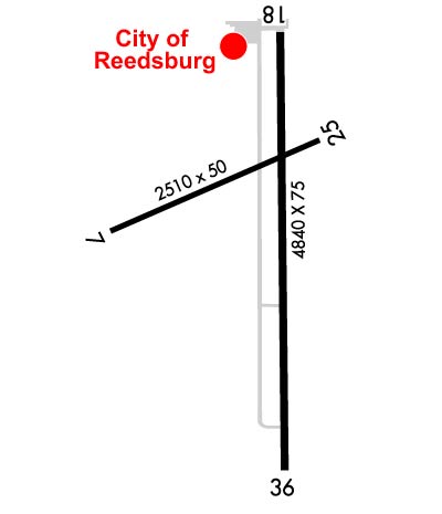
Airport Diagram might not be current.

Facility Name: REEDSBURG MUNI
City Name: REEDSBURG
County: SAUK
State abbrev: WI
State Name: WISCONSIN
   
Ownership: PUBLICLY OWNED
Use: OPEN TO THE PUBLIC
Owner's Name: CITY OF REEDSBURG
Address: ARPT COMSN 200 VINE STREET
 REEDSBURG, WI 53959
Owner's Phone: 608-524-2396
  
Manager's Name: TOM PARKER
Address: 1720 E MAIN; EMAIL ADDRESS: REEDSBURGAVIATION@GMAIL.COM (ALL LOWER CASE)
 REEDSBURG, WI 53959
Phone: 608-524-2322
   
FAA Region: GREAT LAKES
FAA Field Office: CHI


Sunrise / Sunset times for REEDSBURG MUNI

DateSunriseSunset
04/17/24 Wednesday6:1319:47
04/18/24 Thursday6:1119:48
04/19/24 Friday6:1019:49
04/20/24 Saturday6:0819:50
04/21/24 Sunday6:0619:51
04/22/24 Monday6:0519:52
04/23/24 Tuesday6:0319:54
04/24/24 Wednesday6:0219:55
04/25/24 Thursday6:0019:56
04/26/24 Friday5:5919:57
04/27/24 Saturday5:5719:58
04/28/24 Sunday5:5620:00
04/29/24 Monday5:5420:01
04/30/24 Tuesday5:5320:02

Airport Facilities

Airport Attendance Schedule7 Days A Week 0800-1600
Airport Status OPERATIONAL (This Status can change at any time - please check NOTAMS)
Airport Lighting ScheduleMIRL RYS 18/36 & 07/25 PRESET ON LOW INTST, TO INCR INTST & ACTVT REIL RYS 18 & 36 & PAPI RY 18 - CTAF.
Airport Storage AvailableTie Downs, Hanger
Extra Services AvailableFlight Instruction, Aircraft Rental
Wind IndicatorYES - (lighted)
Control TowerNO
CTAF Frequency122.800
Unicom Frequency122.800
Rotating Beacon ColorWG
Segmented CircleYES
Landing FeeNO

Airport Inspection Data

Airport InspectedSTATE - performed by STATE AERONAUTICAL PERSONNEL
Inspection Date04/09/2021

Airport Services

Type of Fuel AvailableGrade 100LL, JET A (freeze point -40C); -1024 HR FUEL AVBL WITH CREDIT CARD.
Airframe Repair ServiceMAJOR
Power Plant Repair ServiceMAJOR

Geographic Data

LatitudeN4331.6
LongitudeW08959.0 (ESTIMATED)
Arpt Elevation906ft (SURVEYED)
Magnetic Variation00E
1 miles Eof REEDSBURG
Traffic Pattern Altitude
Sectional ChartCHICAGO

Aircraft Data

Operations (Reported)YearlyAvg. Daily
General Aviation Transient 715020
General Aviation Local 675018
Air Taxi 2501
Commerical 00
Commuter 00
Military 1500
Aircraft based on Field
General Aviation Singles 19
General Aviation Multi 1
Jet Aircraft 0
General Aviation Helicopters 0
Military Aircraft 0
Gliders 0
Ultralights 0

FAA Services

FSS on field NO
FSS tie-in GREEN BAY
FSS Phone 1-800-WX-BRIEF
Who issues Notams GRB
Notam D service at airport YES
ARTCC Name CHICAGO

Federal Status

Airport Certification
Aircraft Rescue & Firefighting IndexNone
Airport of EntryNo
Custom Landing RightsNo
Joint Civil/MilitaryNo
Military Landing rightsYES

Federal Agreements

NATIONAL PLAN OF INTEGRATED AIRPORT SYSTEMS (NPIAS)

Remarks

FOR CD CTC MADISON APP/DEP CON AT 608-249-8240. WHEN MADISON APCH CLSD, FOR CD CTC CHICAGO ARTCC AT 630-906-8921.
Airport Communications & Frequencies:
CTAF Frequency:
122.800
Unicom Frequency:
122.800
Remarks
  • APCH/DEP SVC PRVDD BY CHICAGO ARTCC ON FREQS 133.3/257.925 (LONE ROCK RCAG) WHEN MADISON APCH CTL CLSD.
  • MADISON Primary Approach Frequencies:  
    135.45
    343.7
    MADISON Primary Departure Frequencies:  
    135.45
    343.7
    Runway Identifications
    Runway Identification: 07/25
    Length: 2510 ft
    Width: 50 ft
    Surface: ASPHALT-GOOD CONDITION
    Edge lights: Medium Intensity

    Treatment: NONE

     Runway: 07   Runway: 25
    Mag heading: 69°Mag heading: 249°
    Rwy Slope: .59% UpRwy Slope: -.59% Down
    Approach: Approach:
    Pattern: Left TrafficPattern: Left Traffic
    Markings: BASICMarkings: BASIC
    Marking Condition: GOODMarking Condition: GOOD
    Arresting Dev: Arresting Dev:
    Lat & Long: N4331.6  W08959.4Lat. & Long.: N4331.7  W08958.8
    Elev: 891.5 ft. MSLElev: 906.2 ft. MSL
    TCH: TCH:
    Visual Glide Path: Visual Glide Path:
    Displaced Threshold: 229 feetDisplaced Threshold: 300 feet
    Touchdown Zone: YESTouchdown Zone: YES
    Touchdown Elev.: 906.2 feetTouchdown Elev.: 906.2 feet
    Visual Glide Slope: Visual Glide Slope:
    RVR Equipment: RVR Equipment:
    RVV Equipment: NORVV Equipment: NO
    Approach Lights: Approach Lights:
    REIL: NOREIL: NO
    Centerline Lights: NOCenterline Lights: NO
    Touchdown lights: NOTouchdown lights: NO
    Runway Category: Runway with a Visual ApproachRunway Category: Runway with a Visual Approach
    Declared Distances: TORA:2210' TODA:2210' ASDA:2210' LDA:1980'Declared Distances: TORA:2280' TODA:2280' ASDA:2280' LDA:1980'
    Obstructions: TREEObstructions: ROAD
    Marked: NOT Marked/LightedMarked: NOT Marked/Lighted
    Clearance slope: 12:1; APCH RATIO 20:1 TO DSPLCD THR.Clearance slope: APCH RATIO 20:1 TO DSPLCD THR.
    Obstruction height: 58 feet AGLObstruction height: 12 feet AGL
    Dist. from runway: 900 feetDist. from runway: 200 feet
    Centerline offset: 200 left of centerlineCenterline offset:
    Comments: DITCH 10 FT FM RWY END 60 FT L.Comments: 10 FT FENCE 175 FT FM RWY END, 40 FT L.
    Runway Identification: 18/36
    Length: 4840 ft
    Width: 75 ft
    Surface: ASPHALT-FAIR CONDITION
    Edge lights: Medium Intensity

    Treatment: NONE

     Runway: 18   Runway: 36
    Mag heading: 181°Mag heading:
    Rwy Slope: -.49% DownRwy Slope: .49% Up
    Approach: Approach:
    Pattern: Left TrafficPattern: Left Traffic
    Markings: NONPRECISION INSTRUMENTMarkings: NONPRECISION INSTRUMENT
    Marking Condition: GOODMarking Condition: GOOD
    Arresting Dev: Arresting Dev:
    Lat & Long: N4331.9  W08958.9Lat. & Long.: N4331.1  W08958.9
    Elev: 904.9 ft. MSLElev: 881.4 ft. MSL
    TCH: 25 ft. AGLTCH:
    Visual Glide Path: 3.00 degreesVisual Glide Path:
    Displaced Threshold: 440 feetDisplaced Threshold: 300 feet
    Touchdown Zone: YESTouchdown Zone: YES
    Touchdown Elev.: 904.5 feetTouchdown Elev.: 903.0 feet
    Visual Glide Slope: 2-Light PAPI on LEFT side of RunwayVisual Glide Slope:
    RVR Equipment: RVR Equipment:
    RVV Equipment: NORVV Equipment: NO
    Approach Lights: Approach Lights:
    REIL: YESREIL: YES
    Centerline Lights: NOCenterline Lights: NO
    Touchdown lights: NOTouchdown lights: NO
    Runway Category: Runway with a Non-precision Approach having visibility minimums greater than 3/4 mileRunway Category: Runway with a Non-precision Approach having visibility minimums greater than 3/4 mile
    Declared Distances: TORA:4540' TODA:4540' ASDA:4540' LDA:4100'Declared Distances: TORA:4400' TODA:4400' ASDA:4400' LDA:4100'
    Obstructions: ROADObstructions: RR
    Marked: NOT Marked/LightedMarked: NOT Marked/Lighted
    Clearance slope: 1:1; APCH RATIO 25:1 TO DSPLCD THR.Clearance slope: APCH RATIO 20:1 TO DSPLCD THR.
    Obstruction height: 21 feet AGLObstruction height: 17 feet AGL
    Dist. from runway: 230 feetDist. from runway: 200 feet
    Centerline offset: Centerline offset: 180 feet left of centerline
    Comments: 10 FT FENCE 190 FT FM RWY END, 120 FT R.Comments: 17 FT RR 75 FT FM RWY END 250 FT L.
    C:1/P: