Current Weather/Notams (Metars, TAFs, Notams, NWS Forecast, PIREPS, and nearby weather)
Customs Information Send updates to Support@FltPlan.com
Customs Not Available
Database effective 05/16/2024
Airport Diagram might not be current. Facility Name: MIDDLETON MUNI/MOREY FLD City Name: MIDDLETON County: DANE State abbrev: WI State Name: WISCONSIN Ownership: PUBLICLY OWNED Use: OPEN TO THE PUBLIC Owner's Name: CITY OF MIDDLETON Address: 7426 HUBBARD AVENUE MIDDLETON, WI 53562 Owner's Phone: 608-827-1050 Manager's Name: RICHARD MOREY Address: 8300 AIRPORT ROAD, 7426 HUBBARD AVE MIDDLETON, WI 53562 Phone: 608-836-1711 FAA Region: GREAT LAKES FAA Field Office: CHI
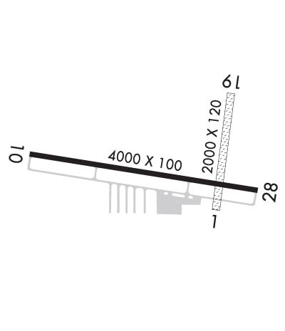
Runway Identifications Help
Runway Identification: 01/19 Length: 1780 ftWidth: 120 ftSurface: GRASS-GOOD CONDITIONEdge lights: Treatment: NONE Runway: 01 Runway: 19 Mag heading: 8° Mag heading: 188° Rwy Slope: .08% Up Rwy Slope: -.08% Down Approach: Approach: Pattern: Left Traffic Pattern: Left Traffic Markings: NONSTANDARD Markings: NONSTANDARD Marking Condition: FAIR; MKD WITH YELLOW CONES. Marking Condition: FAIR; MKD WITH YELLOW CONES. Arresting Dev: Arresting Dev: Lat & Long: N4306.8 W08931.7 Lat. & Long.: N4307.1 W08931.7 Elev: 926.1 ft. MSL Elev: 927.6 ft. MSL TCH: TCH: Visual Glide Path: Visual Glide Path: Displaced Threshold: No Displaced Threshold: No Touchdown Zone: YES Touchdown Zone: YES Touchdown Elev.: 927.9 feet Touchdown Elev.: 927.9 feet Visual Glide Slope: Visual Glide Slope: RVR Equipment: RVR Equipment: RVV Equipment: NO RVV Equipment: NO Approach Lights: Approach Lights: REIL: NO REIL: NO Centerline Lights: NO Centerline Lights: NO Touchdown lights: NO Touchdown lights: NO Runway Category: Runway with a Visual Approach Runway Category: Runway with a Visual Approach Declared Distances: Declared Distances:
Runway Identification: 10/28 Length: 4001 ftWidth: 100 ftSurface: ASPHALT-FAIR CONDITIONEdge lights: Medium Intensity Treatment: NONE Runway: 10 Runway: 28 Mag heading: 101° Mag heading: 281° Rwy Slope: -.03% Down Rwy Slope: .03% Up Approach: LOC/DME Approach: Pattern: Left Traffic Pattern: Left Traffic Markings: NONPRECISION INSTRUMENT Markings: NONPRECISION INSTRUMENT Marking Condition: FAIR Marking Condition: FAIR Arresting Dev: Arresting Dev: Lat & Long: N4306.9 W08932.4 Lat. & Long.: N4306.8 W08931.6 Elev: 927.9 ft. MSL Elev: 926.8 ft. MSL TCH: 31 ft. AGL TCH: 36 ft. AGL Visual Glide Path: 4.00 degrees Visual Glide Path: 4.00 degrees Displaced Threshold: No Displaced Threshold: No Touchdown Zone: YES Touchdown Zone: YES Touchdown Elev.: 928.0 feet Touchdown Elev.: 927.5 feet Visual Glide Slope: 2-Light PAPI on LEFT side of Runway Visual Glide Slope: 2-Light PAPI on LEFT side of Runway RVR Equipment: RVR Equipment: RVV Equipment: NO RVV Equipment: NO Approach Lights: Approach Lights: REIL: YES REIL: YES Centerline Lights: NO Centerline Lights: NO Touchdown lights: NO Touchdown lights: NO Runway Category: Runway with a Non-precision Approach Runway Category: Runway with a Non-precision Approach Declared Distances: Declared Distances: