Current Weather/Notams (Metars, TAFs, Notams, NWS Forecast, PIREPS, and nearby weather)
Customs Information Send updates to Support@FltPlan.com
Customs Not Available
Database effective 05/16/2024
Airport Diagram might not be current.
|
| Facility Name: | OCEANA COUNTY |
| City Name: | HART/SHELBY |
| County: | OCEANA |
| State abbrev: | MI |
| State Name: | MICHIGAN |
| | |
| Ownership: | PUBLICLY OWNED |
| Use: | OPEN TO THE PUBLIC |
| Owner's Name: | OCEANA COUNTY COURT HOUSE |
| Address: | 100 S STATE ST, PO BOX 14 |
| | HART, MI 49420-1188 |
| Owner's Phone: | 231-873-4835 |
| | |
| Manager's Name: | CURT LOHMAN |
| Address: | 1805 BASELINE RD |
| | SHELBY, MI 49455-9630 |
| Phone: | 231-861-9910; CELL 231-742-0142. |
| | |
| FAA Region: | GREAT LAKES |
| FAA Field Office: | DET |
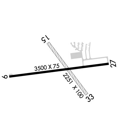
Runway Identifications
Runway Identification: 09/27Length: 3500 ft
Width: 75 ft
Surface: ASPHALT-GOOD CONDITION
Edge lights: Medium IntensityTreatment: NONE
| | Runway: 09 | | Runway: 27 |
| Mag heading: | 88° | Mag heading: | 268° |
| Rwy Slope: | -.40% Down | Rwy Slope: | .40% Up |
| Approach: | | Approach: | |
| Pattern: | Left Traffic | Pattern: | Left Traffic |
| Markings: | NONPRECISION INSTRUMENT | Markings: | NONPRECISION INSTRUMENT |
| Marking Condition: | GOOD | Marking Condition: | GOOD |
| Arresting Dev: | | Arresting Dev: | |
| Lat & Long: | N4338.5 W08620.2 | Lat. & Long.: | N4338.5 W08619.4 |
| Elev: | 915.8 ft. MSL | Elev: | 901.9 ft. MSL |
| TCH: | 25 ft. AGL | TCH: | 25 ft. AGL |
| Visual Glide Path: | 4.00 degrees | Visual Glide Path: | 4.00 degrees |
| Displaced Threshold: | No | Displaced Threshold: | No |
| Touchdown Zone: | YES | Touchdown Zone: | YES |
| Touchdown Elev.: | 915.8 feet | Touchdown Elev.: | 911.8 feet |
| Visual Glide Slope: | 2-Light PAPI on LEFT side of Runway | Visual Glide Slope: | 2-Light PAPI on LEFT side of Runway |
| RVR Equipment: | | RVR Equipment: | |
| RVV Equipment: | NO | RVV Equipment: | NO |
| Approach Lights: | | Approach Lights: | |
| REIL: | NO | REIL: | NO |
| Centerline Lights: | NO | Centerline Lights: | NO |
| Touchdown lights: | NO | Touchdown lights: | NO |
| Runway Category: | Runway with a Non-precision Approach | Runway Category: | Runway with a Non-precision Approach |
| Declared Distances: | | Declared Distances: | |
| Obstructions: | TREES | Obstructions: | TREES |
| Marked: | NOT Marked/Lighted | Marked: | NOT Marked/Lighted |
| Clearance slope: | 16:1 | Clearance slope: | 16:1 |
| Obstruction height: | 121 feet AGL | Obstruction height: | 38 feet AGL |
| Dist. from runway: | 2215 feet | Dist. from runway: | 842 feet |
| Centerline offset: | 325 right of centerline | Centerline offset: | 312 feet left of centerline |
| Comments: | | Comments: | |
Runway Identification: 15/33Length: 2251 ft
Width: 100 ft
Surface: GRASS-GOOD CONDITION
Edge lights: Treatment: NONE
| | Runway: 15 | | Runway: 33 |
| Mag heading: | 148° | Mag heading: | 328° |
| Rwy Slope: | -.40% Down | Rwy Slope: | .40% Up |
| Approach: | | Approach: | |
| Pattern: | Left Traffic | Pattern: | Left Traffic |
| Markings: | | Markings: | |
| Marking Condition: | FAIR; RWY & DTHR MKD WITH 3 FT YELLOW CONES. | Marking Condition: | FAIR; RWY & DTHR MKD WITH 3 FT YELLOW CONES. |
| Arresting Dev: | | Arresting Dev: | |
| Lat & Long: | N4338.7 W08619.9 | Lat. & Long.: | N4338.4 W08619.6 |
| Elev: | 897.3 ft. MSL | Elev: | 888.2 ft. MSL |
| TCH: | | TCH: | |
| Visual Glide Path: | | Visual Glide Path: | |
| Displaced Threshold: | 369 feet | Displaced Threshold: | 557 feet |
| Touchdown Zone: | YES | Touchdown Zone: | YES |
| Touchdown Elev.: | 899.1 feet | Touchdown Elev.: | 899.1 feet |
| Visual Glide Slope: | | Visual Glide Slope: | |
| RVR Equipment: | | RVR Equipment: | |
| RVV Equipment: | NO | RVV Equipment: | NO |
| Approach Lights: | | Approach Lights: | |
| REIL: | NO | REIL: | NO |
| Centerline Lights: | NO | Centerline Lights: | NO |
| Touchdown lights: | NO | Touchdown lights: | NO |
| Runway Category: | Runway with a Visual Approach | Runway Category: | Runway with a Visual Approach |
| Declared Distances: | | Declared Distances: | |
| Obstructions: | ROAD | Obstructions: | TREES |
| Marked: | NOT Marked/Lighted | Marked: | NOT Marked/Lighted |
| Clearance slope: | 1:1; APCH RATIO 20:1 TO DTHR. | Clearance slope: | 1:1; APCH RATIO 18:1 TO DTHR OVR 104 FT TREES, 1865 FT DIST. |
| Obstruction height: | 15 feet AGL | Obstruction height: | 5 feet AGL |
| Dist. from runway: | 0 feet | Dist. from runway: | 8 feet |
| Centerline offset: | | Centerline offset: | 107 feet left of centerline |
| Comments: | | Comments: | |

