Current Weather/Notams (Metars, TAFs, Notams, NWS Forecast, PIREPS, and nearby weather)
Customs Information Send updates to Support@FltPlan.com
Customs Not Available
Database effective 04/18/2024
Airport Diagram might not be current.
|
| Facility Name: | BURLEY MUNI |
| City Name: | BURLEY |
| County: | CASSIA |
| State abbrev: | ID |
| State Name: | IDAHO |
| | |
| Ownership: | PUBLICLY OWNED |
| Use: | OPEN TO THE PUBLIC |
| Owner's Name: | CITY OF BURLEY |
| Address: | P.O. BOX 1090 |
| | BURLEY, ID 83318 |
| Owner's Phone: | 208-878-2224 |
| | |
| Manager's Name: | KEVIN GEBHART |
| Address: | P.O. BOX 157 |
| | BURLEY, ID 83318 |
| Phone: | 208-678-0372 |
| | |
| FAA Region: | NORTHWEST MOUNTAIN |
| FAA Field Office: | HLN |
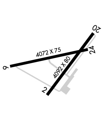
Runway Identifications
Runway Identification: 02/20Length: 4092 ft
Width: 80 ft
Surface: ASPHALT-FAIR CONDITION
Edge lights: Medium IntensityTreatment: NONE
| | Runway: 02 | | Runway: 20 |
| Mag heading: | 22° | Mag heading: | 202° |
| Rwy Slope: | -.30% Down | Rwy Slope: | .30% Up |
| Approach: | | Approach: | |
| Pattern: | Left Traffic | Pattern: | Left Traffic |
| Markings: | BASIC | Markings: | NONPRECISION INSTRUMENT |
| Marking Condition: | GOOD | Marking Condition: | GOOD |
| Arresting Dev: | | Arresting Dev: | |
| Lat & Long: | N4232.3 W11346.4 | Lat. & Long.: | N4232.8 W11345.9 |
| Elev: | 4153.3 ft. MSL | Elev: | 4140.9 ft. MSL |
| TCH: | 46 ft. AGL | TCH: | |
| Visual Glide Path: | 3.50 degrees | Visual Glide Path: | |
| Displaced Threshold: | 626 feet | Displaced Threshold: | 305 feet |
| Touchdown Zone: | YES | Touchdown Zone: | YES |
| Touchdown Elev.: | 4152.6 feet | Touchdown Elev.: | 4152.4 feet |
| Visual Glide Slope: | 4-BOX VASI ON LEFT SIDE OF RUNWAY | Visual Glide Slope: | |
| RVR Equipment: | | RVR Equipment: | |
| RVV Equipment: | NO | RVV Equipment: | NO |
| Approach Lights: | | Approach Lights: | |
| REIL: | NO | REIL: | YES |
| Centerline Lights: | NO | Centerline Lights: | NO |
| Touchdown lights: | NO | Touchdown lights: | NO |
| Runway Category: | Runway with a Visual Approach | Runway Category: | Runway with a Non-precision Approach having visibility minimums greater than 3/4 mile |
| Declared Distances: | | Declared Distances: | |
| Obstructions: | ROAD | Obstructions: | STACK |
| Marked: | NOT Marked/Lighted | Marked: | NOT Marked/Lighted |
| Clearance slope: | 27' RR 620'; 190'R FM DSPLCD THR 22:1. | Clearance slope: | 23:1; RY 20 39:1 TO DSPLCD THLD. |
| Obstruction height: | 20 feet AGL | Obstruction height: | 80 feet AGL |
| Dist. from runway: | 200 feet | Dist. from runway: | 2100 feet |
| Centerline offset: | | Centerline offset: | 100 feet right of centerline |
| Comments: | +15' FT RR SIGNAL 60 FT FM THLD AND 160 FT R; +6 FT FENCE 20 FT FM THLD ON CNTRLN; +27 FT RR 80 FT FM THLD ON CNTRLN | Comments: | |
Runway Identification: 06/24Length: 4072 ft
Width: 75 ft
Surface: ASPHALT-FAIR CONDITION
Edge lights: Medium IntensityTreatment: NONE
| | Runway: 06 | | Runway: 24 |
| Mag heading: | 64° | Mag heading: | 244° |
| Rwy Slope: | -.25% Down | Rwy Slope: | .25% Up |
| Approach: | | Approach: | |
| Pattern: | Left Traffic | Pattern: | Left Traffic |
| Markings: | BASIC | Markings: | BASIC |
| Marking Condition: | FAIR | Marking Condition: | FAIR |
| Arresting Dev: | | Arresting Dev: | |
| Lat & Long: | N4232.5 W11346.9 | Lat. & Long.: | N4232.7 W11346.0 |
| Elev: | 4152.9 ft. MSL | Elev: | 4142.8 ft. MSL |
| TCH: | | TCH: | 52 ft. AGL |
| Visual Glide Path: | | Visual Glide Path: | 3.00 degrees |
| Displaced Threshold: | 796 feet | Displaced Threshold: | 115 feet |
| Touchdown Zone: | YES | Touchdown Zone: | YES |
| Touchdown Elev.: | 4151.6 feet | Touchdown Elev.: | 4151.3 feet |
| Visual Glide Slope: | | Visual Glide Slope: | 2-Box VASI on RIGHT side of Runway |
| RVR Equipment: | | RVR Equipment: | |
| RVV Equipment: | NO | RVV Equipment: | NO |
| Approach Lights: | | Approach Lights: | |
| REIL: | NO | REIL: | NO |
| Centerline Lights: | NO | Centerline Lights: | NO |
| Touchdown lights: | NO | Touchdown lights: | NO |
| Runway Category: | Runway with a Visual Approach | Runway Category: | Runway with a Visual Approach |
| Declared Distances: | | Declared Distances: | |
| Obstructions: | RR | Obstructions: | TREE |
| Marked: | NOT Marked/Lighted | Marked: | LIGHTED |
| Clearance slope: | 27' RR 800'; 120'R FM DSPLCD THR 29:1. | Clearance slope: | 16:1 |
| Obstruction height: | 27 feet AGL | Obstruction height: | 32 feet AGL |
| Dist. from runway: | 200 feet | Dist. from runway: | 735 feet |
| Centerline offset: | 35 left of centerline | Centerline offset: | 80 feet left of centerline |
| Comments: | 27' RR 175' ON CNTRLN; +8' FENCE 0' FM THR 80' R. | Comments: | |

