Current Weather/Notams (Metars, TAFs, Notams, NWS Forecast, PIREPS, and nearby weather)
Customs Information Send updates to Support@FltPlan.com
Customs Not Available
Database effective 04/18/2024
Airport Diagram might not be current. Facility Name: BURKE COUNTY City Name: WAYNESBORO County: BURKE State abbrev: GA State Name: GEORGIA Ownership: PUBLICLY OWNED Use: OPEN TO THE PUBLIC Owner's Name: BURKE COUNTY Address: COUNTY COURTHOUSE PO BOX 89 WAYNESBORO, GA 30830 Owner's Phone: 706-554-2324 Manager's Name: LOUIS FOSS; COUNTY ADMINISTRATOR. Address: PO BOX 89 WAYNESBORO, GA 30830 Phone: 706-554-5270; ARPT PHONE 706-554-5270. FAA Region: SOUTHERN FAA Field Office: ATL
Runway Identifications Help
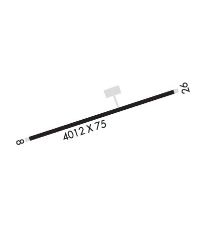
Runway Identification: 08/26 Length: 5003 ftWidth: 75 ftSurface: ASPHALTEdge lights: Medium Intensity Treatment: NONE Runway: 08 Runway: 26 Mag heading: 75° Mag heading: 255° Rwy Slope: .43% Up Rwy Slope: -.43% Down Approach: Approach: Pattern: Left Traffic Pattern: Left Traffic Markings: NONPRECISION INSTRUMENT Markings: NONPRECISION INSTRUMENT Marking Condition: GOOD Marking Condition: GOOD Arresting Dev: Arresting Dev: Lat & Long: N3302.3 W08200.7 Lat. & Long.: N3302.6 W08159.8 Elev: 287.1 ft. MSL Elev: 308.7 ft. MSL TCH: 40 ft. AGL TCH: 40 ft. AGL Visual Glide Path: 3.00 degrees Visual Glide Path: 3.00 degrees Displaced Threshold: No Displaced Threshold: 100 feet Touchdown Zone: YES Touchdown Zone: YES Touchdown Elev.: 300.9 feet Touchdown Elev.: 307.8 feet Visual Glide Slope: 2-Light PAPI on LEFT side of Runway Visual Glide Slope: 2-Light PAPI on RIGHT side of Runway RVR Equipment: RVR Equipment: RVV Equipment: NO RVV Equipment: NO Approach Lights: Approach Lights: REIL: YES REIL: NO Centerline Lights: NO Centerline Lights: NO Touchdown lights: NO Touchdown lights: NO Runway Category: Runway with a Non-precision Approach having visibility minimums greater than 3/4 mile Runway Category: Runway with a Non-precision Approach having visibility minimums greater than 3/4 mile Declared Distances: TORA:5003' TODA:5003' ASDA:5003' LDA:5003' Declared Distances: TORA:5003' TODA:5003' ASDA:5003' LDA:4903' Obstructions: TREES Obstructions: ROAD Marked: NOT Marked/Lighted Marked: NOT Marked/Lighted Clearance slope: Clearance slope: APCH TO DSPLCD THLD IS 0:1, ROAD 200 FT LEFT AT DSPLCD THLD. Obstruction height: 28 feet AGL Obstruction height: 15 feet AGL Dist. from runway: 201 feet Dist. from runway: 201 feet Centerline offset: 155 left of centerline Centerline offset: 200 feet left of centerline Comments: Comments: COUNTY RD 200 FT LEFT FM PARL THE RWY TO MIDFIELD; +3-6 FT BERM 0-200 FT FROM END OF RWY 165 FT LEFT.