
| ||||||
| ||||||
|
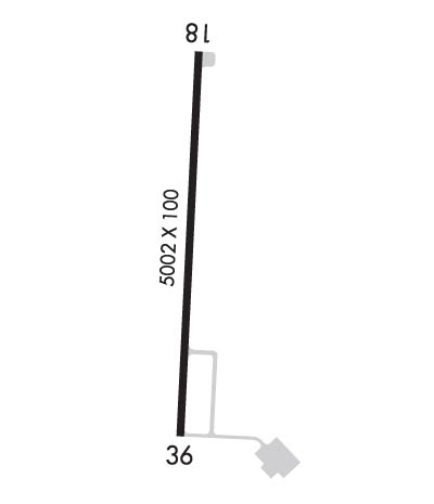
| Rwy | Rwy | |||||||
| 5002x100 | 5002' | 111.10 - 183° | 5002x100 | 5002' | ||||
| Runway ID | Single Wheel | Double Wheel | Double Tandem Wheel | Dual Double Wheel |
| 18/36 | 22,000 | N/A | N/A | N/A |
| These numbers are Advisory and are not limits. The Airport Manager should have more accurate Weight Limits | ||||
 Airport Diagram might not be current. | |
| Facility Name: | GEORGE R CARR MEML AIR FLD |
| City Name: | BOGALUSA |
| County: | WASHINGTON |
| State abbrev: | LA |
| State Name: | LOUISIANA |
| Ownership: | PUBLICLY OWNED |
| Use: | OPEN TO THE PUBLIC |
| Owner's Name: | CITY OF BOGALUSA |
| Address: | PO DRAWER 1179 |
| BOGALUSA, LA 70429-1179 | |
| Owner's Phone: | 985-732-6200 |
| Manager's Name: | JOHN SANDERS |
| Address: | 401 WALKER STREET |
| BOGALUSA, LA 70427 | |
| Phone: | 985-732-6200; AFTER HOURS 985-750-0485. |
| FAA Region: | SOUTHWEST |
| FAA Field Office: | LNM |
| Date | Sunrise | Sunset |
|---|---|---|
| 04/17/24 Wednesday | 6:29 | 19:29 |
| 04/18/24 Thursday | 6:28 | 19:30 |
| 04/19/24 Friday | 6:27 | 19:31 |
| 04/20/24 Saturday | 6:26 | 19:31 |
| 04/21/24 Sunday | 6:24 | 19:32 |
| 04/22/24 Monday | 6:23 | 19:33 |
| 04/23/24 Tuesday | 6:22 | 19:33 |
| 04/24/24 Wednesday | 6:21 | 19:34 |
| 04/25/24 Thursday | 6:20 | 19:35 |
| 04/26/24 Friday | 6:19 | 19:35 |
| 04/27/24 Saturday | 6:18 | 19:36 |
| 04/28/24 Sunday | 6:17 | 19:37 |
| 04/29/24 Monday | 6:17 | 19:37 |
| 04/30/24 Tuesday | 6:16 | 19:38 |
| Airport Attendance Schedule | 7 Days A Week 0800-1700 |
| Airport Status | OPERATIONAL (This Status can change at any time - please check NOTAMS) |
| Airport Lighting Schedule | DUSK-DAWN. REIL RWYS 18 & 36; MIRL RWY 18/36 PRESET LOW INTST DUSK-DAWN; TO INCR INTST - CTAF. |
| Airport Storage Available | Tie Downs, Hanger |
| Extra Services Available | NONE |
| Wind Indicator | YES - (lighted) |
| Control Tower | NO |
| CTAF Frequency | 122.800 |
| Unicom Frequency | 122.800 |
| Rotating Beacon Color | WG |
| Segmented Circle | NO |
| Landing Fee | NO |
| Airport Inspected | STATE - performed by STATE AERONAUTICAL PERSONNEL |
| Inspection Date | 04/14/2023 |
| Type of Fuel Available | Grade 100LL, JET A (freeze point -40C); -A SINGLE POINT & OVERWING FUELING AVBL. 24 HRS SELF SERVICE WITH CREDIT CARD.; -10FUEL AVBL 24 HRS SELF SERVE WITH CREDIT CARD. |
| Airframe Repair Service | MAJOR |
| Power Plant Repair Service | MAJOR |
| Latitude | N3048.8 |
| Longitude | W08951.9 (ESTIMATED) |
| Arpt Elevation | 119ft (SURVEYED) |
| Magnetic Variation | 00W |
| 2 miles N | of BOGALUSA |
| Traffic Pattern Altitude | |
| Sectional Chart | NEW ORLEANS |
| Operations (Reported) | Yearly | Avg. Daily |
|---|---|---|
| General Aviation Transient | 8000 | 22 |
| General Aviation Local | 16000 | 44 |
| Air Taxi | 0 | 0 |
| Commerical | 0 | 0 |
| Commuter | 0 | 0 |
| Military | 0 | 0 |
| Aircraft based on Field | |
|---|---|
| General Aviation Singles | 11 |
| General Aviation Multi | 1 |
| Jet Aircraft | 0 |
| General Aviation Helicopters | 0 |
| Military Aircraft | 0 |
| Gliders | 0 |
| Ultralights | 0 |
| FSS on field | NO |
| FSS tie-in | DE RIDDER |
| FSS Phone | 1-800-WX-BRIEF |
| Who issues Notams | DRI |
| Notam D service at airport | YES |
| ARTCC Name | HOUSTON |
| Airport Certification | |
| Aircraft Rescue & Firefighting Index | None |
| Airport of Entry | No |
| Custom Landing Rights | No |
| Joint Civil/Military | No |
| Military Landing rights | YES |
| NATIONAL PLAN OF INTEGRATED AIRPORT SYSTEMS (NPIAS) |
| GRANT AGREEMENT HAS EXPIRED; HOWEVER, AGREEMENT REMAINS IN EFFECT FOR THIS FACILITY AS LONG AS IT IS PUBLIC USE. |
| THIS AIRPORT HAS BEEN SURVEYED BY THE NATIONAL GEODETIC SURVEY. |
| FOR CD CTC HOUSTON ARTCC AT 281-230-5622. |
Airport Communications & Frequencies:
| |||||||||
| Runway: 18 | Runway: 36 | ||
| Mag heading: | 183° | Mag heading: | 3° |
| Rwy Slope: | -.16% Down | Rwy Slope: | .16% Up |
| Approach: | LOCALIZER | Approach: | |
| Pattern: | Left Traffic | Pattern: | Left Traffic |
| Markings: | NONPRECISION INSTRUMENT | Markings: | NONPRECISION INSTRUMENT |
| Marking Condition: | FAIR | Marking Condition: | FAIR |
| Arresting Dev: | Arresting Dev: | ||
| Lat & Long: | N3049.2 W08951.9 | Lat. & Long.: | N3048.4 W08951.9 |
| Elev: | 118.7 ft. MSL | Elev: | 110.5 ft. MSL |
| TCH: | 50 ft. AGL | TCH: | 52 ft. AGL |
| Visual Glide Path: | 3.00 degrees | Visual Glide Path: | 3.00 degrees |
| Displaced Threshold: | No | Displaced Threshold: | No |
| Touchdown Zone: | YES | Touchdown Zone: | YES |
| Touchdown Elev.: | 118.7 feet | Touchdown Elev.: | 117.3 feet |
| Visual Glide Slope: | 2-Light PAPI on LEFT side of Runway | Visual Glide Slope: | 2-Light PAPI on LEFT side of Runway |
| RVR Equipment: | RVR Equipment: | ||
| RVV Equipment: | NO | RVV Equipment: | NO |
| Approach Lights: | Approach Lights: | ||
| REIL: | YES | REIL: | YES |
| Centerline Lights: | NO | Centerline Lights: | NO |
| Touchdown lights: | NO | Touchdown lights: | NO |
| Runway Category: | Runway with a Non-precision Approach having visibility minimums greater than 3/4 mile | Runway Category: | Runway with a Non-precision Approach having visibility minimums greater than 3/4 mile |
| Declared Distances: | Declared Distances: | ||
| Obstructions: | TREES | Obstructions: | TREES |
| Marked: | NOT Marked/Lighted | Marked: | NOT Marked/Lighted |
| Clearance slope: | 35:1 | Clearance slope: | 20:1 |
| Obstruction height: | 50 feet AGL | Obstruction height: | 87 feet AGL |
| Dist. from runway: | 1976 feet | Dist. from runway: | 1989 feet |
| Centerline offset: | B | Centerline offset: | 480 feet right of centerline |
| Comments: | Comments: |
