Current Weather/Notams (Metars, TAFs, Notams, NWS Forecast, PIREPS, and nearby weather)
Customs Information Send updates to Support@FltPlan.com
Customs Not Available
Database effective 05/16/2024
Airport Diagram might not be current.
|
| Facility Name: | HARRY STERN |
| City Name: | WAHPETON |
| County: | RICHLAND |
| State abbrev: | ND |
| State Name: | NORTH DAKOTA |
| | |
| Ownership: | PUBLICLY OWNED |
| Use: | OPEN TO THE PUBLIC |
| Owner's Name: | WAHPETON ARPT AUTH |
| Address: | 1251 PEGASUS ROAD |
| | WAHPETON, ND 58075 |
| Owner's Phone: | 701-642-5777 |
| | |
| Manager's Name: | JON KLEIN |
| Address: | 1251 PEGASUS ROAD |
| | WAHPETON, ND 58075 |
| Phone: | 701-642-5777; ADDNL PHONE 701-361-0230 OR CITY POLICE 701-642-7777. |
| | |
| FAA Region: | GREAT LAKES |
| FAA Field Office: | DMA |
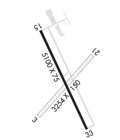
Runway Identifications
Runway Identification: 03/21Length: 3254 ft
Width: 150 ft
Surface: GRASS-FAIR CONDITION
Edge lights: Treatment: NONE
| | Runway: 03 | | Runway: 21 |
| Mag heading: | 33° | Mag heading: | 213° |
| Rwy Slope: | -.06% Down | Rwy Slope: | .06% Up |
| Approach: | | Approach: | |
| Pattern: | Left Traffic | Pattern: | Left Traffic |
| Markings: | | Markings: | |
| Marking Condition: | RWY 03/21 MKD WITH EDGE & CORNER DALGT METAL MKRS PAINTED ORANGE. | Marking Condition: | |
| Arresting Dev: | | Arresting Dev: | |
| Lat & Long: | N4614.5 W09636.7 | Lat. & Long.: | N4614.9 W09636.2 |
| Elev: | 966.6 ft. MSL | Elev: | 964.8 ft. MSL |
| TCH: | | TCH: | |
| Visual Glide Path: | | Visual Glide Path: | |
| Displaced Threshold: | No | Displaced Threshold: | No |
| Touchdown Zone: | YES | Touchdown Zone: | YES |
| Touchdown Elev.: | 966.9 feet | Touchdown Elev.: | 966.9 feet |
| Visual Glide Slope: | | Visual Glide Slope: | |
| RVR Equipment: | | RVR Equipment: | |
| RVV Equipment: | NO | RVV Equipment: | NO |
| Approach Lights: | | Approach Lights: | |
| REIL: | NO | REIL: | NO |
| Centerline Lights: | NO | Centerline Lights: | NO |
| Touchdown lights: | NO | Touchdown lights: | NO |
| Runway Category: | Runway with a Visual Approach | Runway Category: | Runway with a Visual Approach |
| Declared Distances: | | Declared Distances: | |
| Obstructions: | TREES | Obstructions: | |
| Marked: | NOT Marked/Lighted | Marked: | |
| Clearance slope: | 18:1 | Clearance slope: | 20:1 |
| Obstruction height: | 49 feet AGL | Obstruction height: | |
| Dist. from runway: | 886 feet | Dist. from runway: | |
| Centerline offset: | 138B | Centerline offset: | |
| Comments: | | Comments: | |
Runway Identification: 15/33Length: 5100 ft
Width: 75 ft
Surface: CONCRETE-GOOD CONDITION
Edge lights: Medium IntensityTreatment: NONE
| | Runway: 15 | | Runway: 33 |
| Mag heading: | 151° | Mag heading: | 331° |
| Rwy Slope: | -.04% Down | Rwy Slope: | .04% Up |
| Approach: | | Approach: | |
| Pattern: | Left Traffic | Pattern: | Left Traffic |
| Markings: | NONPRECISION INSTRUMENT | Markings: | NONPRECISION INSTRUMENT |
| Marking Condition: | FAIR | Marking Condition: | FAIR |
| Arresting Dev: | | Arresting Dev: | |
| Lat & Long: | N4615.0 W09636.7 | Lat. & Long.: | N4614.3 W09636.2 |
| Elev: | 968.1 ft. MSL | Elev: | 966.2 ft. MSL |
| TCH: | 42 ft. AGL | TCH: | 26 ft. AGL |
| Visual Glide Path: | 3.00 degrees | Visual Glide Path: | 3.00 degrees |
| Displaced Threshold: | No | Displaced Threshold: | No |
| Touchdown Zone: | YES | Touchdown Zone: | YES |
| Touchdown Elev.: | 968.2 feet | Touchdown Elev.: | 967.5 feet |
| Visual Glide Slope: | 2-Light PAPI on LEFT side of Runway | Visual Glide Slope: | 2-Light PAPI on LEFT side of Runway |
| RVR Equipment: | | RVR Equipment: | |
| RVV Equipment: | NO | RVV Equipment: | NO |
| Approach Lights: | | Approach Lights: | |
| REIL: | YES | REIL: | YES |
| Centerline Lights: | NO | Centerline Lights: | NO |
| Touchdown lights: | NO | Touchdown lights: | NO |
| Runway Category: | Runway with a Non-precision Approach having visibility minimums greater than 3/4 mile | Runway Category: | Runway with a Non-precision Approach having visibility minimums greater than 3/4 mile |
| Declared Distances: | | Declared Distances: | |
| Obstructions: | TREES; 32 FT TREES 1250 FT FROM THLD BOTH SIDES OF EXTDD CNTRLN APCH RATIO 32:1. | Obstructions: | TREES |
| Marked: | NOT Marked/Lighted | Marked: | NOT Marked/Lighted |
| Clearance slope: | 26:1 | Clearance slope: | 28:1 |
| Obstruction height: | 45 feet AGL | Obstruction height: | 42 feet AGL |
| Dist. from runway: | 1400 feet | Dist. from runway: | 1410 feet |
| Centerline offset: | 80 right of centerline | Centerline offset: | 130B |
| Comments: | | Comments: | |

