KBWI

BALTIMORE/WASHINGTON INTL
BALTIMORE
MD
Time Zone: Eastern
Lat: N 3910.5
Long: W 07640.1
Elev: 143
Var: +11
Longest Runway: 10503
Clr Del: 118.05
Dept. ATIS: 127.8
Arr. ATIS: 115.1/127.8
Ground: 121.9
Tower: 119.4

FBO & Flight Services info for KBWI

FBOs: Update your Fuel Prices

SIGNATUREPh: 410-859-8393 Fax: 410-850-9042 Freq: 129.0
Service
Jet
100LL
SAF
MoGas
Fuel Avail: PRIST +$0.06/gal.
Full9.929.00    Last Update: 04/23/2024 09:38

Self        
 Address: PO BOX 8786, 2 AARONSON DRIVE,   BALTIMORE, MD 21240-9972
BALTIMORE HELI SVPh: 410-675-8888
-
-

ASOSPh: 410-691-1278
-
-
 
If you are an FBO, call 1-203-262-1700 to update your info or email: FltPlan.Advertising@garmin.com
Advertise your FBO on FltPlan.com
FBOs at nearby airports who want your business:
KMTN

GETTING TO AND FROM MARTIN STATE AIRPORT IS EASY!

From the airways to the roadways and back, you can't beat the Martin approach to accessibility and convenience. We are located on the east side of Baltimore County and less than 10 minutes from I-95. We know your time is valuable, and we will help you make the most of it. We have the best fuel prices in the area.
Ph: 410-682-8810 WebsiteE-MailFax: 410-682-8842 Freq: 122.95

Runway & Approach Info for KBWI
Rwy
Length
Land Dist**
Approach*
  Rwy
Length
Land Dist**
Approach*
10
10503x150  9953'          
ILS
 109.70 - 105°  
  
28
  10503x150  9803'          
ILS
 109.70 - 285°  
15L
5000x100  5000'          
ILS
 111.95 - 155°  
  
33R
  5000x100  5000'          
ILS
 111.95 - 335°  
15R
9501x150  9200'          
ILS
 111.70 - 155°  
  
33L
  9501x150  9001'          
ILS
 111.70 - 335°  
 * only ILS, LOC, LDA, and SDF approaches to a specific runway are shown
** For any Declared Landing Distance Available, please see A/FD or Approach plates
Runway Weight Capability (lbs.) Help
Runway IDSingle WheelDouble WheelDouble Tandem WheelDual Double Wheel
10/2880,000220,0001,020,0001,340,000
15L/33R30,00045,000N/AN/A
15R/33L80,000220,000675,000890,000
These numbers are Advisory and are not limits.   The Airport Manager should have more accurate Weight Limits
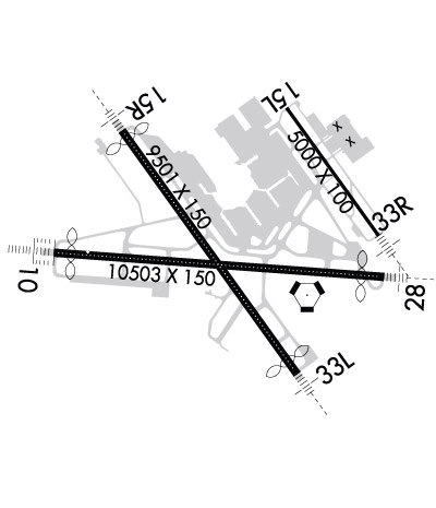
Approach Charts
Approaches    
Current Weather/Notams
Customs Information Send updates to Support@FltPlan.com
Phone 410-865-2100
Fax 410-865-2126

Comments 2 hrs advance notice required Business hrs 0800-1700 Monday-Sunday *Maximum passengers per flight: 10 *Call prior to 1700 on preceding day for after-hours service.
Database effective 05/16/2024
Airport Diagram of KBWI
Airport Diagram might not be current.

Facility Name: BALTIMORE/WASHINGTON INTL THURGOOD MARSHALL
City Name: BALTIMORE
County: ANNE ARUNDEL
State abbrev: MD
State Name: MARYLAND
   
Ownership: PUBLICLY OWNED
Use: OPEN TO THE PUBLIC
Owner's Name: STATE OF MARYLAND
Address: PO BOX 8766
 BWI AIRPORT, MD 21240-0766
Owner's Phone: 410-859-7100
  
Manager's Name: GREGORY SOLEK
Address: PO BOX 8766
 BWI AIRPORT, MD 21240-0766
Phone: 410-859-7024
   
FAA Region: EASTERN
FAA Field Office: DCA


Sunrise / Sunset times for BALTIMORE/WASHINGTON INTL THURGOOD MARSHALL

DateSunriseSunset
04/22/24 Monday6:1919:52
04/23/24 Tuesday6:1819:53
04/24/24 Wednesday6:1619:54
04/25/24 Thursday6:1519:55
04/26/24 Friday6:1419:56
04/27/24 Saturday6:1219:57
04/28/24 Sunday6:1119:58
04/29/24 Monday6:1019:59
04/30/24 Tuesday6:0920:00
05/01/24 Wednesday6:0720:01
05/02/24 Thursday6:0620:01
05/03/24 Friday6:0520:02
05/04/24 Saturday6:0420:03
05/05/24 Sunday6:0320:04

Airport Facilities

Airport Attendance ScheduleCONTINUOUS
Airport Status OPERATIONAL (This Status can change at any time - please check NOTAMS)
Airport Lighting Schedule
Airport Storage AvailableTie Downs, Hanger
Extra Services AvailableAir Freight, Cargo Handling, Charter, Flight Instruction, Aircraft Rental, Aircraft Sales
Wind IndicatorYES - (lighted)
Control TowerYES
CTAF Frequency
Unicom Frequency
Rotating Beacon ColorWG
Segmented CircleYES
Landing FeeYES

Airport Inspection Data

Airport Inspected5010-1 PUBLIC USE MAILOUT PROGRAM - performed by FAA AIRPORTS FIELD PERSONNEL
Inspection Date02/21/2023

Airport Services

Type of Fuel AvailableGrade 100LL, JET A (freeze point -40C)
Airframe Repair ServiceMAJOR
Power Plant Repair ServiceMAJOR

Geographic Data

LatitudeN3910.5
LongitudeW07640.1 (ESTIMATED; SURVEYED.)
Arpt Elevation143ft (SURVEYED)
Magnetic Variation11W
9 miles Sof BALTIMORE
Traffic Pattern Altitude
Sectional ChartWASHINGTON

Aircraft Data

Operations (Reported)YearlyAvg. Daily
General Aviation Transient 1204233
General Aviation Local 00
Air Taxi 1704147
Commerical 189242518
Commuter 00
Military 9513
Aircraft based on Field
General Aviation Singles 27
General Aviation Multi 4
Jet Aircraft 11
General Aviation Helicopters 0
Military Aircraft 0
Gliders 0
Ultralights 0

FAA Services

FSS on field NO
FSS tie-in LEESBURG
FSS Phone 1-800-WX-BRIEF
Who issues Notams BWI
Notam D service at airport YES
ARTCC Name WASHINGTON

Federal Status

Airport CertificationAIRPORT RECEIVING SCHEDULED AIR CARRIER SERVICE FROM CARRIERS CERTIFICATED BY THE CIVIL AERONAUTICS BOARD
Aircraft Rescue & Firefighting IndexAIRPORT HAS A CERTIFICATE UNDER CFR PART 139
Airport of EntryNo
Custom Landing RightsYES
Joint Civil/MilitaryNo
Military Landing rightsYES

Federal Agreements

NATIONAL PLAN OF INTEGRATED AIRPORT SYSTEMS (NPIAS)
GRANT AGREEMENTS UNDER FAAP/ADAP/AIP
COMPLIANCE WITH ACCESSIBILITY TO THE HANDICAPPED
ASSURANCES PURSUANT TO TITLE VI, CIVIL RIGHTS ACT OF 1964

Remarks

NOISE ABATEMENT PROCEDURES IN EFFECT - RSTRN FOR RWY 15L/33R EXCEPT FOR EMERG OR MERCY FLIGHTS CTC AMGR FOR INFO.
MAJOR CONSTR ON ARPT DLY; ACFT MOV & PRKG AREAS SUBJECT TO SHORT NOTICE CHANGE/CLOSURE. FOR CURRENT INFO PHONE BWI OPNS CNTR 410-859-7018.
ACFT ON VISUAL APCHS EXPECT TO MAINTAIN 3000 FT UNTIL 10 DME FM BAL VORTAC; DEP ACFT SHOULD EXPECT TURNS BASED ON BALTIMORE DME.
TAXIING PROHIBITED BTN CONCOURSE C & ADJ BLDG STRUCTURE SW OF CONCOURSE C. ACCESS TO GATE C12 MUST BE VIA TWY A.
RWY 15R DEICE PAD, POSITION # 1, RSTRD TO ACFT WITH WINGSPAN OF 156 FT 1 INCH OR LESS & LENGTH OF 180 FT 3 INCHES OR LESS. PSN'S #2 & #3 ARE RSTD TO ACFT WITH A WINGSPAN OF 156 FT 1 INCH OR LESS, POSITION #3 IS RSTRD TO ACFT WITH A WINGSPAN OF 156 FT 1 INCH OR LESS & LENGTH OF 180 FT 3 INCHES OR LESS; POSITION 4 RSTRD TO ACFT WITH WINGSPAN OF 213 FT OR LESS & LENGTH OF 229 FT 2 INCHES OR LESS.
TWY "S", SOUTH OF TWY "P", RSTRD TO ACFT 60000 LBS & LESS.
GENERAL AVIATION ACFT CTC UNICOM PRIOR TO ARRIVING AT GENERAL AVIATION RAMP FOR SECURITY PURPOSES.
PRACTICE LNDG & APCH BY TURBO-PWRD ACFT PROHIBITED 2200-0600; PRACTICE LNDG & TKOF BY B-747 ACFT PROHIBITED RWY 15R/33L.
TAXILANES 'T-1' & "H" RSTRD TO GROUP III ACFT WITH MAX WINGSPAN OF 118 FEET.
CONCOURSE A ALT DEICING AREA IS RSTRD TO B737-800 SIZE ACFT WITH WINGLETS OR SMLR ON SPOTS 6, 7 AND 8.
RWY 28 DE-ICE PAD LANE 1 RSTRD TO ACFT WITH WINGSPAN 171 FT OR LESS, LANE 2 RSTRD TO ACFT WITH WINGSPAN 135 FT OR LESS, LANE 3 IS USED BY LARGE ACFT MAX WINGSPAN 215 FT AND WHEN IN USE- LANES 2 AND 4 ARE UNAVBL. LANES 4, 5 & 6 ARE RSTRD TO ACFT WINGSPAN 135 FT OR LESS.
CONT MOWING OPERATIONS ADJ ALL RWYS & TWYS - APR THRU NOV.
TWY T BTN TWY H AND TWY E RSTD TO GROUP IV ACFT WITH WINGSPAN LESS THAN 171 FT. TWY T BTN TWY E AND TWY B RSTRD TO GROUP V ACFT WITH WINGSPAN LESS THAN 214 FT; WHEN GROUP V ACFT ARE ON TWY T, TWY A IS RSTRD TO MAX WINGSPANS OF 110 FT.
ASDE-X IN USE. OPERATE TRANSPONDERS WITH ALT REPORTING MODE AND ADS-B (IF EQUIPPED) ENABLED ON ALL ARPT SURFACES.
DUAL PARALLEL TAXILANES HAVE BEEN ADDED TO THE 'D'/'E' ALLEYWAY; TAXILANE 'N' AND TAXILANE 'N1'. TAXILANE 'N' IS DESIGNATED A "GROUP V" TAXILANE WITH MAX WINGSPAN OF 213 FT. TAXILANE 'N1' IS DESIGNATED A "GROUP IV" TAXILANE WITH MAX WINGSPAN OF 170 FT.
TWY 'A' IS RSTRD TO GROUP IV ACFT WINGSPAN 171 FT OR LESS.
RWY LEN AVBL FOR RWY 28 DEPS FM TWY U1 IS 9802 FT.
RWY STATUS LGTS IN OPN.
ACFT DEPARTING RWY 28 EXP DEP FM TWY U1.
DURING ATC ZERO EVENTS, UNICOM 119.4.
NO APRON PARKING FOR UNSKED ACR.
UNICOM 119.4.
DEER & BIRDS OCNLLY ON & INVOF ARPT.
DISTRACTING LGTS (GOLF DRIVING RANGE) RIGHT SIDE EXTDD CNTRLN RWY 33L FM AER TO 1/4 MI FINAL.
Airport Communications & Frequencies:
ATIS Frequencies:   Hours(local) of Operation: CONTINUOUS
115.1
127.8
BALTIMORE Tower Frequencies:   Hours(local) of operation: CONTINUOUS   
119.4
257.8
BALTIMORE Ground Frequencies:
121.9
Clearance Delivery Frequencies:
118.05
Emergency Frequencies:
121.5
243.0
Remarks
  • ARRIVALS MAY BE EXTENDED OUTSIDE OF CLASS B.
  • POTOMAC Primary Approach Frequencies:  
    119.0 020-100
    119.7 131-180
    124.55 101-130
    128.7 181-019
    282.275 020-100
    290.475 131-180
    307.9 181-019
    317.425 101-130
    Part-time Approach Frequencies:  
    119.0 131-180
    119.7 020-130
    125.525 181-019
    282.275 131-180
    290.475 020-130
    POTOMAC Primary Departure Frequencies:  
    124.55 EAST
    128.7 WEST
    307.9 WEST
    317.425 EAST
    Class B Frequencies:
    119.0 020-100
    119.0 131-180
    119.7 020-130
    119.7 131-180
    124.55 101-130
    125.525 181-019
    128.7 181-019
    282.275 020-100
    282.275 131-180
    290.475 020-130
    290.475 131-180
    307.9 181-019
    317.425 101-130
    Runway Identifications
    Runway Identification: 10/28
    Length: 10503 ft
    Width: 150 ft
    Surface: ASPHALT-GOOD CONDITION
    Edge lights: High Intensity

    Treatment: GROOVED
    Weight: PCN 105/F/A/W/T

     Runway: 10   Runway: 28
    Mag heading: 105°Mag heading: 285°
    Rwy Slope: -.12% DownRwy Slope: .12% Up
    Approach: ILSApproach: ILS
    Pattern: Left TrafficPattern: Left Traffic
    Markings: PRECISION INSTRUMENTMarkings: PRECISION INSTRUMENT
    Marking Condition: GOODMarking Condition: GOOD
    Arresting Dev: Arresting Dev:
    Lat & Long: N3910.5  W07641.4Lat. & Long.: N3910.4  W07639.2
    Elev: 139.0 ft. MSLElev: 126.4 ft. MSL
    TCH: 71 ft. AGLTCH: 75 ft. AGL
    Visual Glide Path: 3.00 degreesVisual Glide Path: 3.00 degrees
    Displaced Threshold: 550 feetDisplaced Threshold: 700 feet
    Touchdown Zone: YESTouchdown Zone: YES
    Touchdown Elev.: 143.4 feetTouchdown Elev.: 142.7 feet
    Visual Glide Slope: 4-Light PAPI on RIGHT side of RunwayVisual Glide Slope: 4-Light PAPI on LEFT side of Runway
    RVR Equipment: TOUCHDOWN-MIDFIELD-ROLLOUT; MIDFIELD RVR SENSOR SHARED BY RWY 10/28 & RWY 15R/33L.RVR Equipment: TOUCHDOWN-MIDFIELD-ROLLOUT
    RVV Equipment: YESRVV Equipment: NO
    Approach Lights: ALSF2 - standard 2,400 foot high intensity approach lighting system with sequenced flashers, Category II or IIIApproach Lights: MALSR - 1,400 foot medium intensity approach lighting system with runway alignment indicator lights
    REIL: NOREIL: NO
    Centerline Lights: YESCenterline Lights: YES
    Touchdown lights: YESTouchdown lights: NO
    Runway Category: Precision Instrument RunwayRunway Category: Precision Instrument Runway
    Declared Distances: TORA:10503' TODA:10503' ASDA:10503' LDA:9953'Declared Distances: TORA:10503' TODA:10503' ASDA:10503' LDA:9803'
    Obstructions: TREEObstructions: TREE
    Marked: NOT Marked/LightedMarked: NOT Marked/Lighted
    Clearance slope: 40:1; APCH RATIO 50:1 TO DSPLCD THR.Clearance slope: 33:1; APCH RATIO 50:1 TO DSPLCD THR.
    Obstruction height: 35 feet AGLObstruction height: 31 feet AGL
    Dist. from runway: 1606 feetDist. from runway: 1230 feet
    Centerline offset: 305 right of centerlineCenterline offset: 425 feet right of centerline
    Comments: Comments:
    Runway Identification: 15L/33R
    Length: 5000 ft
    Width: 100 ft
    Surface: ASPHALT-FAIR CONDITION
    Edge lights: High Intensity

    Treatment: GROOVED
    Weight: PCN 15 /F/A/W/T

     Runway: 15L   Runway: 33R
    Mag heading: 155°Mag heading: 335°
    Rwy Slope: -.55% DownRwy Slope: .55% Up
    Approach: ILSApproach: ILS
    Pattern: Left TrafficPattern: Left Traffic
    Markings: PRECISION INSTRUMENTMarkings: PRECISION INSTRUMENT
    Marking Condition: GOODMarking Condition: GOOD
    Arresting Dev: Arresting Dev:
    Lat & Long: N3911.2  W07639.8Lat. & Long.: N3910.6  W07639.2
    Elev: 141.4 ft. MSLElev: 114.0 ft. MSL
    TCH: 47 ft. AGLTCH: 47 ft. AGL
    Visual Glide Path: 3.00 degreesVisual Glide Path: 3.00 degrees
    Displaced Threshold: NoDisplaced Threshold: No
    Touchdown Zone: YESTouchdown Zone: YES
    Touchdown Elev.: 141.5 feetTouchdown Elev.: 124.4 feet
    Visual Glide Slope: 4-Light PAPI on LEFT side of RunwayVisual Glide Slope: 4-Light PAPI on LEFT side of Runway
    RVR Equipment: TOUCHDOWN-ROLLOUTRVR Equipment: TOUCHDOWN-ROLLOUT
    RVV Equipment: NORVV Equipment: NO
    Approach Lights: Approach Lights: MALSR - 1,400 foot medium intensity approach lighting system with runway alignment indicator lights
    REIL: YESREIL: YES
    Centerline Lights: NOCenterline Lights: NO
    Touchdown lights: NOTouchdown lights: NO
    Runway Category: Precision Instrument RunwayRunway Category: Precision Instrument Runway
    Declared Distances: TORA:5000' TODA:5000' ASDA:5000' LDA:5000'Declared Distances: TORA:5000' TODA:5000' ASDA:5000' LDA:5000'
    Obstructions: POLEObstructions: TREE
    Marked: NOT Marked/LightedMarked: NOT Marked/Lighted
    Clearance slope: 30:1Clearance slope: 32:1
    Obstruction height: 31 feet AGLObstruction height: 39 feet AGL
    Dist. from runway: 1120 feetDist. from runway: 1470 feet
    Centerline offset: 615 right of centerlineCenterline offset: 585 feet right of centerline
    Comments: Comments:
    Runway Identification: 15R/33L
    Length: 9501 ft
    Width: 150 ft
    Surface: ASPHALT-GOOD CONDITION
    Edge lights: High Intensity

    Treatment: GROOVED
    Weight: PCN 70 /F/A/W/T

     Runway: 15R   Runway: 33L
    Mag heading: 155°Mag heading: 335°
    Rwy Slope: -.10% DownRwy Slope: .10% Up
    Approach: ILSApproach: ILS
    Pattern: Left TrafficPattern: Left Traffic
    Markings: PRECISION INSTRUMENTMarkings: PRECISION INSTRUMENT
    Marking Condition: GOODMarking Condition: GOOD
    Arresting Dev: Arresting Dev:
    Lat & Long: N3911.1  W07640.9Lat. & Long.: N3909.9  W07639.7
    Elev: 139.0 ft. MSLElev: 129.6 ft. MSL
    TCH: 73 ft. AGLTCH: 72 ft. AGL
    Visual Glide Path: 3.00 degreesVisual Glide Path: 3.00 degrees
    Displaced Threshold: 301 feetDisplaced Threshold: 500 feet
    Touchdown Zone: YESTouchdown Zone: YES
    Touchdown Elev.: 138.3 feetTouchdown Elev.: 142.7 feet
    Visual Glide Slope: 4-Light PAPI on RIGHT side of RunwayVisual Glide Slope: 4-Light PAPI on LEFT side of Runway
    RVR Equipment: TOUCHDOWN-MIDFIELD-ROLLOUTRVR Equipment: TOUCHDOWN-MIDFIELD-ROLLOUT
    RVV Equipment: YESRVV Equipment: NO
    Approach Lights: MALSR - 1,400 foot medium intensity approach lighting system with runway alignment indicator lightsApproach Lights: MALSR - 1,400 foot medium intensity approach lighting system with runway alignment indicator lights
    REIL: NOREIL: NO
    Centerline Lights: YESCenterline Lights: YES
    Touchdown lights: NOTouchdown lights: YES
    Runway Category: Precision Instrument RunwayRunway Category: Precision Instrument Runway
    Declared Distances: TORA:9501' TODA:9501' ASDA:8601' LDA:8301'Declared Distances: TORA:9501' TODA:9501' ASDA:8801' LDA:8301'
    Obstructions: ANTObstructions: TOWER
    Marked: LIGHTEDMarked: NOT Marked/Lighted
    Clearance slope: 35:1Clearance slope: 47:1
    Obstruction height: 126 feet AGLObstruction height: 154 feet AGL
    Dist. from runway: 4724 feetDist. from runway: 7460 feet
    Centerline offset: 908 left of centerlineCenterline offset: 906 feet left of centerline
    Comments: Comments: RWY 33L +2 FT ROAD 170 FT FROM RWY END 500 FT LEFT.
    C:196/P: