Current Weather/Notams (Metars, TAFs, Notams, NWS Forecast, PIREPS, and nearby weather)
Customs Information Send updates to Support@FltPlan.com
Phone 978-921-0782
Fax 978-922-8312
Comments On call basis. 2 hrs advance notice required. Business hrs 0800-1700 Monday-Friday.
Database effective 05/16/2024
Airport Diagram might not be current.
|
| Facility Name: | BEVERLY RGNL |
| City Name: | BEVERLY |
| County: | ESSEX |
| State abbrev: | MA |
| State Name: | MASSACHUSETTS |
| | |
| Ownership: | PUBLICLY OWNED |
| Use: | OPEN TO THE PUBLIC |
| Owner's Name: | CITY OF BEVERLY |
| Address: | CITY HALL, CABOT ST |
| | BEVERLY, MA 01915 |
| Owner's Phone: | 978-921-6000 |
| | |
| Manager's Name: | GABRIEL HANAFIN |
| Address: | 50 LP HENDERSON RD |
| | BEVERLY, MA 01915 |
| Phone: | 978-921-6072 |
| | |
| FAA Region: | NEW ENGLAND |
| FAA Field Office: | NONE |
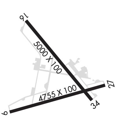
Runway Identifications
Runway Identification: 09/27Length: 4755 ft
Width: 100 ft
Surface: ASPHALT-GOOD CONDITION
Edge lights: Medium IntensityTreatment: GROOVED
| | Runway: 09 | | Runway: 27 |
| Mag heading: | 90° | Mag heading: | 270° |
| Rwy Slope: | .41% Up | Rwy Slope: | -.41% Down |
| Approach: | | Approach: | |
| Pattern: | Left Traffic | Pattern: | Left Traffic |
| Markings: | NONPRECISION INSTRUMENT | Markings: | NONPRECISION INSTRUMENT |
| Marking Condition: | GOOD | Marking Condition: | GOOD |
| Arresting Dev: | | Arresting Dev: | |
| Lat & Long: | N4234.8 W07055.5 | Lat. & Long.: | N4235.0 W07054.5 |
| Elev: | 71.6 ft. MSL | Elev: | 91.3 ft. MSL |
| TCH: | 43 ft. AGL | TCH: | 46 ft. AGL |
| Visual Glide Path: | 3.00 degrees | Visual Glide Path: | 3.22 degrees |
| Displaced Threshold: | No | Displaced Threshold: | 250 feet |
| Touchdown Zone: | YES | Touchdown Zone: | YES |
| Touchdown Elev.: | 85.8 feet | Touchdown Elev.: | 91.2 feet |
| Visual Glide Slope: | 4-Light PAPI on LEFT side of Runway | Visual Glide Slope: | 4-Light PAPI on LEFT side of Runway |
| RVR Equipment: | | RVR Equipment: | |
| RVV Equipment: | NO | RVV Equipment: | NO |
| Approach Lights: | | Approach Lights: | |
| REIL: | NO | REIL: | NO |
| Centerline Lights: | NO | Centerline Lights: | NO |
| Touchdown lights: | NO | Touchdown lights: | NO |
| Runway Category: | Runway with a Visual Approach | Runway Category: | Runway with a Non-precision Approach having visibility minimums greater than 3/4 mile |
| Declared Distances: | | Declared Distances: | |
| Obstructions: | TREE | Obstructions: | TREES |
| Marked: | NOT Marked/Lighted | Marked: | NOT Marked/Lighted |
| Clearance slope: | 6:1 | Clearance slope: | 8:1; 50:1 TO DTHR. |
| Obstruction height: | 15 feet AGL | Obstruction height: | 22 feet AGL |
| Dist. from runway: | 300 feet | Dist. from runway: | 396 feet |
| Centerline offset: | 150 left of centerline | Centerline offset: | 125 feet right of centerline |
| Comments: | | Comments: | |
Runway Identification: 16/34Length: 5001 ft
Width: 100 ft
Surface: ASPHALT
Edge lights: Medium IntensityTreatment: GROOVED
| | Runway: 16 | | Runway: 34 |
| Mag heading: | 157° | Mag heading: | 337° |
| Rwy Slope: | -.50% Down | Rwy Slope: | .50% Up |
| Approach: | LOC/DME | Approach: | |
| Pattern: | Left Traffic | Pattern: | Left Traffic |
| Markings: | NONPRECISION INSTRUMENT | Markings: | NONPRECISION INSTRUMENT |
| Marking Condition: | FAIR | Marking Condition: | FAIR |
| Arresting Dev: | | Arresting Dev: | |
| Lat & Long: | N4235.5 W07055.3 | Lat. & Long.: | N4234.9 W07054.6 |
| Elev: | 107.2 ft. MSL | Elev: | 82.1 ft. MSL |
| TCH: | 41 ft. AGL | TCH: | |
| Visual Glide Path: | 3.50 degrees | Visual Glide Path: | |
| Displaced Threshold: | 239 feet | Displaced Threshold: | No |
| Touchdown Zone: | YES | Touchdown Zone: | YES |
| Touchdown Elev.: | 107.3 feet | Touchdown Elev.: | 101.7 feet |
| Visual Glide Slope: | 4-Light PAPI on LEFT side of Runway | Visual Glide Slope: | |
| RVR Equipment: | | RVR Equipment: | |
| RVV Equipment: | NO | RVV Equipment: | NO |
| Approach Lights: | MALS - 1,400 foot medium intensity approach lighting system; NON-STD MALS - 800 FT. | Approach Lights: | |
| REIL: | NO | REIL: | YES |
| Centerline Lights: | NO | Centerline Lights: | NO |
| Touchdown lights: | NO | Touchdown lights: | NO |
| Runway Category: | Runway with a Non-precision Approach having visibility minimums greater than 3/4 mile | Runway Category: | Runway with a Non-precision Approach having visibility minimums greater than 3/4 mile |
| Declared Distances: | | Declared Distances: | |
| Obstructions: | TREES | Obstructions: | Unknown |
| Marked: | NOT Marked/Lighted | Marked: | NOT Marked/Lighted |
| Clearance slope: | 25:1; 30:1 TO DTHR. | Clearance slope: | 20:1 |
| Obstruction height: | 32 feet AGL | Obstruction height: | 27 feet AGL |
| Dist. from runway: | 1000 feet | Dist. from runway: | 750 feet |
| Centerline offset: | 125 right of centerline | Centerline offset: | 75 feet left of centerline |
| Comments: | | Comments: | |

