Current Weather/Notams (Metars, TAFs, Notams, NWS Forecast, PIREPS, and nearby weather)
Customs Information Send updates to Support@FltPlan.com
Customs Not Available
Database effective 05/16/2024
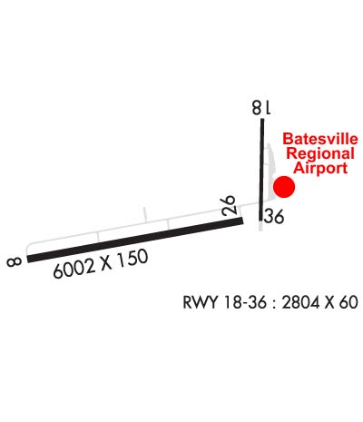
Airport Diagram might not be current. Facility Name: BATESVILLE RGNL City Name: BATESVILLE County: INDEPENDENCE State abbrev: AR State Name: ARKANSAS Ownership: PUBLICLY OWNED Use: OPEN TO THE PUBLIC Owner's Name: CITY OF BATESVILLE Address: 500 EAST MAIN ST. BATESVILLE, AR 72501 Owner's Phone: 870-698-2400 Manager's Name: JUSTIN THOMPSON Address: 1126 BATESVILLE BLVD BATESVILLE, AR 72501 Phone: 870-251-1244 FAA Region: SOUTHWEST FAA Field Office: AOK
Runway Identifications Help
Runway Identification: 08/26 Length: 6002 ftWidth: 150 ftSurface: ASPHALT-FAIR CONDITIONEdge lights: Medium Intensity Treatment: NONE Runway: 08 Runway: 26 Mag heading: 79° Mag heading: 259° Rwy Slope: .21% Up Rwy Slope: -.21% Down Approach: LOC/DME Approach: Pattern: Left Traffic Pattern: Left Traffic Markings: NONPRECISION INSTRUMENT Markings: NONPRECISION INSTRUMENT Marking Condition: GOOD Marking Condition: GOOD Arresting Dev: Arresting Dev: Lat & Long: N3543.4 W09139.7 Lat. & Long.: N3543.6 W09138.5 Elev: 452.2 ft. MSL Elev: 464.6 ft. MSL TCH: 44 ft. AGL TCH: 45 ft. AGL Visual Glide Path: 3.00 degrees Visual Glide Path: 3.00 degrees Displaced Threshold: No Displaced Threshold: No Touchdown Zone: YES Touchdown Zone: YES Touchdown Elev.: 463.0 feet Touchdown Elev.: 465.0 feet Visual Glide Slope: 2-Light PAPI on LEFT side of Runway Visual Glide Slope: 2-Light PAPI on LEFT side of Runway RVR Equipment: RVR Equipment: RVV Equipment: NO RVV Equipment: NO Approach Lights: Approach Lights: REIL: YES REIL: YES Centerline Lights: NO Centerline Lights: NO Touchdown lights: NO Touchdown lights: NO Runway Category: Runway with a Non-precision Approach having visibility minimums greater than 3/4 mile Runway Category: Runway with a Non-precision Approach having visibility minimums greater than 3/4 mile Declared Distances: Declared Distances: Obstructions: Obstructions: TREE Marked: Marked: NOT Marked/Lighted Clearance slope: 50:1 Clearance slope: 35:1 Obstruction height: Obstruction height: 32 feet AGL Dist. from runway: Dist. from runway: 1320 feet Centerline offset: Centerline offset: Comments: Comments:
Runway Identification: 18/36 Length: 2804 ftWidth: 60 ftSurface: ASPHALT-GOOD CONDITIONEdge lights: Treatment: NONE Runway: 18 Runway: 36 Mag heading: 180° Mag heading: 0° Rwy Slope: .89% Up Rwy Slope: -.89% Down Approach: Approach: Pattern: Left Traffic Pattern: Left Traffic Markings: BASIC Markings: BASIC Marking Condition: GOOD Marking Condition: GOOD Arresting Dev: Arresting Dev: Lat & Long: N3544.0 W09138.4 Lat. & Long.: N3543.6 W09138.4 Elev: 435.4 ft. MSL Elev: 460.4 ft. MSL TCH: TCH: Visual Glide Path: Visual Glide Path: Displaced Threshold: No Displaced Threshold: No Touchdown Zone: YES Touchdown Zone: YES Touchdown Elev.: 460.4 feet Touchdown Elev.: 460.4 feet Visual Glide Slope: Visual Glide Slope: RVR Equipment: RVR Equipment: RVV Equipment: NO RVV Equipment: NO Approach Lights: Approach Lights: REIL: NO REIL: NO Centerline Lights: NO Centerline Lights: NO Touchdown lights: NO Touchdown lights: NO Runway Category: Runway with a Visual Approach Runway Category: Runway with a Visual Approach Declared Distances: Declared Distances: Obstructions: TREE Obstructions: ROAD Marked: NOT Marked/Lighted Marked: NOT Marked/Lighted Clearance slope: 13:1 Clearance slope: 7:1 Obstruction height: 45 feet AGL Obstruction height: 10 feet AGL Dist. from runway: 800 feet Dist. from runway: 275 feet Centerline offset: 180 right of centerline Centerline offset: Comments: Comments: