Current Weather/Notams (Metars, TAFs, Notams, NWS Forecast, PIREPS, and nearby weather)
Customs Information Send updates to Support@FltPlan.com
Customs Not Available
Database effective 05/16/2024
Airport Diagram might not be current. Facility Name: BARTLESVILLE MUNI City Name: BARTLESVILLE County: OSAGE State abbrev: OK State Name: OKLAHOMA Ownership: PUBLICLY OWNED Use: OPEN TO THE PUBLIC Owner's Name: CITY OF BARTLESVILLE Address: CITY HALL, 401 S. JOHNSTONE BARTLESVILLE, OK 74003 Owner's Phone: 918-338-4282 Manager's Name: MIKE RICHARDSON Address: 401 NW WILEY POST RD. BARTLESVILLE, OK 74003 Phone: (918) 661-3500; FOR EMERG ONLY 918-350-0076. FAA Region: SOUTHWEST FAA Field Office: AOK
Runway Identifications Help
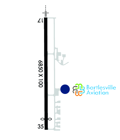
Runway Identification: 17/35 Length: 6850 ftWidth: 100 ftSurface: CONCRETE-GOOD CONDITIONEdge lights: Medium Intensity Treatment: GROOVED Runway: 17 Runway: 35 Mag heading: 176° Mag heading: 356° Rwy Slope: .46% Up Rwy Slope: -.46% Down Approach: LOCALIZER Approach: Pattern: Right Traffic Pattern: Left Traffic Markings: PRECISION INSTRUMENT Markings: PRECISION INSTRUMENT Marking Condition: GOOD Marking Condition: GOOD Arresting Dev: Arresting Dev: Lat & Long: N3646.4 W09600.7 Lat. & Long.: N3645.2 W09600.7 Elev: 685.5 ft. MSL Elev: 716.9 ft. MSL TCH: 53 ft. AGL TCH: 45 ft. AGL Visual Glide Path: 3.00 degrees Visual Glide Path: 3.00 degrees Displaced Threshold: No Displaced Threshold: 649 feet Touchdown Zone: YES Touchdown Zone: YES Touchdown Elev.: 693.8 feet Touchdown Elev.: 711.9 feet Visual Glide Slope: 4-Light PAPI on LEFT side of Runway Visual Glide Slope: 4-Light PAPI on LEFT side of Runway RVR Equipment: RVR Equipment: RVV Equipment: NO RVV Equipment: NO Approach Lights: MALSR - 1,400 foot medium intensity approach lighting system with runway alignment indicator lights Approach Lights: REIL: NO REIL: YES Centerline Lights: NO Centerline Lights: NO Touchdown lights: NO Touchdown lights: NO Runway Category: D Runway Category: Runway with a Non-precision Approach having visibility minimums greater than 3/4 mile Declared Distances: TORA:6201' TODA:6201' ASDA:6201' LDA:6201' Declared Distances: TORA:6850' TODA:6850' ASDA:6850' LDA:6201' Obstructions: TREES Obstructions: Marked: NOT Marked/Lighted Marked: Clearance slope: 12:1 Clearance slope: 34:1 Obstruction height: 31 feet AGL Obstruction height: Dist. from runway: 572 feet Dist. from runway: Centerline offset: 344 right of centerline Centerline offset: Comments: Comments: