KBUR

Whisper PlateWhisper Track
BOB HOPE
BURBANK
CA
Time Zone: Pacific
Lat: N 3412.0
Long: W 11821.5
Elev: 778
Var: -12
Longest Runway: 6886
Clr Del: 118.0
Dept. ATIS: 134.5
Arr. ATIS: 134.5/135.12
Ground: 123.9
Tower: 118.7/132.32

FBO & Flight Services info for KBUR

FBOs: Update your Fuel Prices

  click here  
Open 24 Hours, CAA Member, Quick Turns, Competitive Fuel Prices, Gourmet Catering, Limousine Service, Pilot's Lounge, Satellite Television, Conference Room, Quiet Room, Shower, Wifi Internet Access, Shuttle Service to Nearby Hotels, Over 5 Acres of Ramp Space, On-site Charter Service.

Sustainable Aviation Fuel (SAF) is available at this location!
Ph: 818-843-8311 Fax: 818-843-0140 Freq: 129.62WebsiteE-Mail
                   
Service
Jet
100LL
SAF
MoGas
Fuel Avail: 24 hours - seven days per week
Full6.298.736.65  Last Update: 04/22/2024 15:51
PRICES GUARANTEED by FBO. *
*call for volume discounts and contract fuel
Self        
Misc. Info: Contract Fuel available. Triple AVTRIP points during the Rose Bowl and BCS Championship Games!.
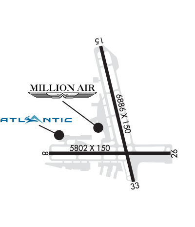
Address: 2800 N CLYBOURN AVE,   BURBANK, CA 91505-1010
Atlantic Aviation is your premier aviation service provider with more than 100 locations in North America, including Hawaii and the Caribbean. We provide standard ground services you'd expect, with a detailed focus on ensuring an unforgettable customer experience.
Ph: 818-841-2966 Fax: 818-840-9159 Freq: 131.6WebsiteE-Mail
                             
Service
Jet
100LL
SAF
MoGas
Full8.299.14    Last Update: 04/24/2024 13:37:44

Self        
Misc. Info: All prices are 'Out The Door', call for volume discountsAddress: 10750 SHERMAN WAY,   BURBANK, CA 91505-1109

ASOSPh: 818-841-1384
-
-
 
ATISPh: 818-843-6633
-
-
 
If you are an FBO, call 1-203-262-1700 to update your info or email: FltPlan.Advertising@garmin.com
Advertise your FBO on FltPlan.com

Runway & Approach Info for KBUR
Rwy
Length
Land Dist**
Approach*
  Rwy
Length
Land Dist**
Approach*
08
5802x150  5802'          
ILS
 109.50 - 078°  
  
26
  5802x150  5802'          
 
15
6886x150  5977'          
 
  
33
  6886x150  6536'          
 
 * only ILS, LOC, LDA, and SDF approaches to a specific runway are shown
** For any Declared Landing Distance Available, please see A/FD or Approach plates
Runway Weight Capability (lbs.) Help
Runway IDSingle WheelDouble WheelDouble Tandem WheelDual Double Wheel
08/26120,000201,000352,000839,000
15/33120,000201,000352,000839,000
These numbers are Advisory and are not limits.   The Airport Manager should have more accurate Weight Limits
Approach Charts
Approaches    
Current Weather/Notams
Customs Information Send updates to Support@FltPlan.com
Customs Not Available
Database effective 05/16/2024
Airport Diagram of KBUR
Airport Diagram might not be current.

Facility Name: BOB HOPE
City Name: BURBANK
County: LOS ANGELES
State abbrev: CA
State Name: CALIFORNIA
   
Ownership: PUBLICLY OWNED
Use: OPEN TO THE PUBLIC
Owner's Name: BURBANK-GLENDALE-PASADENA APT
Address: 2627 HOLLYWOOD WAY
 BURBANK, CA 91505
Owner's Phone: 818-840-8840
  
Manager's Name: THOMAS HENDERSON, DIRECTOR OF OPS
Address: 2627 HOLLYWOOD WAY
 BURBANK, CA 91505
Phone: 818-840-8830
   
FAA Region: WESTERN-PACIFIC
FAA Field Office: LAX


Sunrise / Sunset times for BOB HOPE

DateSunriseSunset
04/24/24 Wednesday6:1119:33
04/25/24 Thursday6:0919:34
04/26/24 Friday6:0819:34
04/27/24 Saturday6:0719:35
04/28/24 Sunday6:0619:36
04/29/24 Monday6:0519:37
04/30/24 Tuesday6:0419:37
05/01/24 Wednesday6:0319:38
05/02/24 Thursday6:0219:39
05/03/24 Friday6:0119:40
05/04/24 Saturday6:0019:41
05/05/24 Sunday5:5919:41
05/06/24 Monday5:5819:42
05/07/24 Tuesday5:5719:43

Airport Facilities

Airport Attendance ScheduleCONTINUOUS
Airport Status OPERATIONAL (This Status can change at any time - please check NOTAMS)
Airport Lighting Schedule
Airport Storage AvailableHanger
Extra Services AvailableAir Freight, Avionics, Cargo Handling, Charter, Flight Instruction, Aircraft Rental, Aircraft Sales
Wind IndicatorYES - (lighted)
Control TowerYES
CTAF Frequency
Unicom Frequency122.950
Rotating Beacon ColorWG
Segmented CircleNO
Landing FeeNO

Airport Inspection Data

Airport InspectedFEDERAL - performed by STATE AERONAUTICAL PERSONNEL
Inspection Date10/31/2023

Airport Services

Type of Fuel AvailableGrade 100LL, JET A (freeze point -40C), JET A
Airframe Repair ServiceMAJOR
Power Plant Repair ServiceMAJOR

Geographic Data

LatitudeN3412.0
LongitudeW11821.5 (ESTIMATED)
Arpt Elevation778ft (SURVEYED)
Magnetic Variation12E
3 miles NWof BURBANK
Traffic Pattern Altitude
Sectional ChartLOS ANGELES

Aircraft Data

Operations (Reported)YearlyAvg. Daily
General Aviation Transient 2845378
General Aviation Local 2606371
Air Taxi 2824177
Commerical 68714188
Commuter 00
Military 4451
Aircraft based on Field
General Aviation Singles 22
General Aviation Multi 6
Jet Aircraft 42
General Aviation Helicopters 11
Military Aircraft 0
Gliders 0
Ultralights 0

FAA Services

FSS on field NO
FSS tie-in HAWTHORNE
FSS Phone 1-800-WX-BRIEF
Who issues Notams BUR
Notam D service at airport YES
ARTCC Name LOS ANGELES

Federal Status

Airport CertificationAIRPORT RECEIVING SCHEDULED AIR CARRIER SERVICE FROM CARRIERS CERTIFICATED BY THE CIVIL AERONAUTICS BOARD
Aircraft Rescue & Firefighting IndexAIRPORT HAS A CERTIFICATE UNDER CFR PART 139
Airport of EntryNo
Custom Landing RightsNo
Joint Civil/MilitaryNo
Military Landing rightsYES

Federal Agreements

NATIONAL PLAN OF INTEGRATED AIRPORT SYSTEMS (NPIAS)
GRANT AGREEMENTS UNDER FAAP/ADAP/AIP
ASSURANCES PURSUANT TO TITLE VI, CIVIL RIGHTS ACT OF 1964

Remarks

ACFT IN TFC PAT (1225 FT AGL) AT WHITEMAN AIRPARK 5 MI NW.
HANG GLIDER ACTIVITY BTN 5 & 10 NM NORTH OF ARPT 6000 FT AGL SR-SS.
TWY G RSTRD TO ACFT WITH WINGSPAN OF 95 FT OR LESS.
POWER ENGINE RUN-UPS FOR ACFT GTR THAN 1200 LBS PROHIBITED IN ALL AREAS EXC ON TWY D RUN-UP AREA OR AS COORDINATED WITH ATCT.
14 FT BLAST FENCE 35 FT FM DEP END RY 15.
14 FT BLAST FENCE 93 FT FM DEP END RY 33.
8 FT BLAST FENCE 260 FT FM DEP END OF RY 26.
14 FT BLAST FENCE 256 FT FROM DEP END RY 08.
TWY A RESTRICTED TO ACFT WITH WINGSPAN OF 171 FT OR LESS.
PILOTS SHOULD CALL AHEAD FOR ARPT NOISE RULES (818) 840-8840.
RSTRNS AND FINES EFF 2200-0700 FOR STAGE 2 JETS, CERTAIN PROPS, RUN-UPS AND FLT TRG ACT, CALL (818) 840-8840 BFR OPRG.
HELICOPTER ARRIVALS RESTRICTED TO RY 08/26 AND 15/33.
TWY B RESTRICTED TO ACFT WITH WINGSPAN OF 79 FT OR LESS BEGINNING 300 FT NORTH OF TWY D AND CONTINUING NORTH.
NO GA ACFT PARKING AT TERMINAL RAMP.
TURBULENT CONDS NEAR ARPT AT TIMES OF HIGH WINDS FROM NORTH & EAST. DOWNDRAFTS/WINDSHEAR MAY OCCUR AT LIFTOFF OR ON FINAL.
ACFT WILL USE EASY PWR WHEN LVG ASGND GATE. CTN MUST BE USED WHEN TAXIING FM TRML AREA DUE TO CLOSE PROXIMITY TO THE TRML. PSNL AND GND EQUIP IN AREA.
ACFT WITH WINGSPAN GTR THAN 95 FT EXP BACK TAXI ON RWY 15/33 FOR A RWY 33 DEP.
ACFT RSTRD FROM TAXIING SB PAST GATE B1 ON TRML RAMP.
ACFT WITH WINGSPAN GTR THAN 79 FT RSTRD FROM USING TWY C W OF TWY C8.
RWY 26 CLSD TO TKOF/JET ACFT WITH FOUR OR MORE ENGS.
X-BLEED STARTS PROHIBITED IN ALL NON-MOVMT AREAS INCLG THE AIRLINE TRML RAMP. ATC MAY APV X-BLEED STARTS ON TWY A NORTH OF TWY D, ALL OTHER REQS MUST BE COORDD AND APVD BY OPS.
WHEN KBUR LDG RWY 08 USE CTN FOR TCAS RA DUE TO ACFT IN KVNY RWY 16L/34R TFC PAT (TPA 1802 MSL).
BIRD ACTIVITY NORTH END RY 15/33 AND WEST END RY 08/26.
RWY 08 CLSD TKOF ACFT GTR THAN 12500 LBS.
Airport Communications & Frequencies:
ATIS Frequencies:   Hours(local) of Operation: CONTINUOUS
134.5
135.125 ;ARR VIA FIM/PMD VORTAC ONLY
BURBANK Tower Frequencies:   Hours(local) of operation: CONTINUOUS   
118.7
132.325 ;HELICOPTERS
254.3
BURBANK Ground Frequencies:
123.9
348.6
Clearance Delivery Frequencies:
118.0
348.6
Emergency Frequencies:
121.5
243.0
Unicom Frequency:
122.950
SOCAL Primary Approach Frequencies:  
120.4 VNY 280-BUR 050, NORTH
124.6 SOUTH BTN BUR 150-VNY 160
134.2 160-280 VNY, WEST
135.05 050-150 BUR
298.85 S BTN BUR 150-VNY 160
317.5 050-150 BUR
338.2 160-280 VNY WEST
360.6 VNY 280-BUR 050 NORTH
SOCAL Primary Departure Frequencies:  
120.4 VNY 280-BUR 050, NORTH
124.6 SOUTH BTN BUR 150-VNY 160
134.2 160-280 VNY, WEST
135.05 050-150 BUR
298.85 S BTN BUR 150-VNY 160
317.5 050-150 BUR
338.2 160-280 VNY WEST
360.6 VNY 280-BUR 050 NORTH
Class B Frequencies:
128.75
Class C Frequencies:
120.4 VNY 280-BUR 050
124.6 SOUTH BTN BUR 150-VNY 160
134.2 160-280 VNY
135.05 050-150 BUR
298.85 S BTN BUR 150-VNY 160
317.5 050-150 BUR
338.2 160-280 VNY
360.6 VNY 280-BUR 050
Runway Identifications
Runway Identification: 08/26
Length: 5802 ft
Width: 150 ft
Surface: CONCRETE ASPHALT
Edge lights: High Intensity

Treatment: GROOVED
Weight: PCN 58 /R/B/W/T

 Runway: 08   Runway: 26
Mag heading: 79°Mag heading: 259°
Rwy Slope: -.52% DownRwy Slope: .52% Up
Approach: ILSApproach:
Pattern: Right TrafficPattern: Left Traffic
Markings: PRECISION INSTRUMENTMarkings: NONPRECISION INSTRUMENT
Marking Condition: GOODMarking Condition: GOOD
Arresting Dev: EMAS; ENGINEERED MATERIAL ARRESTING SYSTEM (EMAS) 170 FT LENGTH BY 350 FT WIDTH LCTD AT THE DER 08.Arresting Dev:
Lat & Long: N3411.9  W11822.1Lat. & Long.: N3411.9  W11821.0
Elev: 727.4 ft. MSLElev: 697.3 ft. MSL
TCH: 61 ft. AGLTCH:
Visual Glide Path: 3.00 degreesVisual Glide Path:
Displaced Threshold: NoDisplaced Threshold: No
Touchdown Zone: YESTouchdown Zone: YES
Touchdown Elev.: 727.4 feetTouchdown Elev.: 716.3 feet
Visual Glide Slope: 4-Light PAPI on LEFT side of RunwayVisual Glide Slope:
RVR Equipment: TOUCHDOWNRVR Equipment: ROLLOUT
RVV Equipment: YESRVV Equipment: NO
Approach Lights: MALSR - 1,400 foot medium intensity approach lighting system with runway alignment indicator lightsApproach Lights:
REIL: NOREIL: YES
Centerline Lights: NOCenterline Lights: NO
Touchdown lights: NOTouchdown lights: NO
Runway Category: Precision Instrument RunwayRunway Category: Runway with a Visual Approach
Declared Distances: TORA:5801' TODA:5801' ASDA:5801' LDA:5801'Declared Distances: TORA:5801' TODA:5801' ASDA:5801' LDA:5801'
Obstructions: ROADObstructions: POLE
Marked: NOT Marked/LightedMarked: NOT Marked/Lighted
Clearance slope: 7:1Clearance slope: 1:1; RWY 26 APCH RATIO 11:1 TO THR.
Obstruction height: 14 feet AGLObstruction height: 40 feet AGL
Dist. from runway: 300 feetDist. from runway: 245 feet
Centerline offset: Centerline offset: 410 feet right of centerline
Comments: Comments: +28' SIGN 90 FT FM RY THLD, +14 FT BLAST FENCE AT THLD.
Runway Identification: 15/33
Length: 6886 ft
Width: 150 ft
Surface: CONCRETE ASPHALT
Edge lights: Medium Intensity

Treatment: GROOVED
Weight: PCN 58 /R/B/W/T

 Runway: 15   Runway: 33
Mag heading: 155°Mag heading: 335°
Rwy Slope: -1.21% DownRwy Slope: 1.21% Up
Approach: Approach:
Pattern: Right TrafficPattern: Left Traffic
Markings: NONPRECISION INSTRUMENTMarkings: NONPRECISION INSTRUMENT
Marking Condition: GOODMarking Condition: GOOD
Arresting Dev: Arresting Dev:
Lat & Long: N3412.7  W11821.6Lat. & Long.: N3411.6  W11821.3
Elev: 778.0 ft. MSLElev: 694.5 ft. MSL
TCH: 34 ft. AGLTCH: 62 ft. AGL
Visual Glide Path: 3.25 degreesVisual Glide Path: 3.20 degrees
Displaced Threshold: 909 feetDisplaced Threshold: 350 feet
Touchdown Zone: YESTouchdown Zone: YES
Touchdown Elev.: 767.9 feetTouchdown Elev.: 735.8 feet
Visual Glide Slope: 4-BOX VASI ON LEFT SIDE OF RUNWAY; VASI UNUSBL BYD 5 DEGREES OF CNTRLN.Visual Glide Slope: 4-Light PAPI on LEFT side of Runway; PAPI UNUSBL BYD 2 DEG RIGHT OF CNTRLN.
RVR Equipment: RVR Equipment:
RVV Equipment: NORVV Equipment: NO
Approach Lights: Approach Lights:
REIL: YESREIL: YES
Centerline Lights: NOCenterline Lights: NO
Touchdown lights: NOTouchdown lights: NO
Runway Category: Runway with a Visual ApproachRunway Category: Runway with a Visual Approach
Declared Distances: TORA:6885' TODA:6885' ASDA:6885' LDA:5976'Declared Distances: TORA:6885' TODA:6885' ASDA:6885' LDA:6535'
Obstructions: RRObstructions: POLE
Marked: NOT Marked/LightedMarked: NOT Marked/Lighted
Clearance slope: APCH RATIO 36:1 TO DSPLCD THR.Clearance slope: APCH RATIO 22:1 TO DSPLCD THR.
Obstruction height: 30 feet AGLObstruction height: 31 feet AGL
Dist. from runway: 200 feetDist. from runway: 201 feet
Centerline offset: 250 left of centerlineCenterline offset: 240 feet right of centerline
Comments: +15 FT ROAD 100-200 FT FROM RY END; +14 FT BLAST FENCE; MULTIPLE LIGHT STANDARDS 15 FT FROM END OF RY.Comments: +20 FT POLE 198 FT FROM RY THR; +14 FT BLAST FENCE AT THR.
C:147/P: