
| ||||||||||||||||||||||||||||||||||||||||||||
| ||||||||||||||||||||||||||||||||||||||||||||
| Rwy | Rwy | |||||||
| 3999x75 | 3999' | 3999x75 | 3999' | |||||
| Runway ID | Single Wheel | Double Wheel | Double Tandem Wheel | Dual Double Wheel |
| 18/36 | 12,000 | N/A | N/A | N/A |
| These numbers are Advisory and are not limits. The Airport Manager should have more accurate Weight Limits | ||||
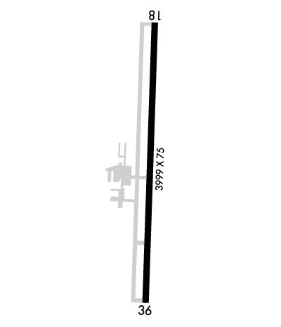 Airport Diagram might not be current. | |
| Facility Name: | BUTLER MEML |
| City Name: | BUTLER |
| County: | BATES |
| State abbrev: | MO |
| State Name: | MISSOURI |
| Ownership: | PUBLICLY OWNED |
| Use: | OPEN TO THE PUBLIC |
| Owner's Name: | CITY OF BUTLER |
| Address: | PO BOX 420 |
| BUTLER, MO 64730 | |
| Owner's Phone: | 660-679-4182 |
| Manager's Name: | MIKE WEST |
| Address: | PO BOX 420, 22 W OHIO |
| BUTLER, MO 64730 | |
| Phone: | 660-679-4013 |
| FAA Region: | CENTRAL |
| FAA Field Office: | NONE |
| Date | Sunrise | Sunset |
|---|---|---|
| 04/23/24 Tuesday | 6:30 | 20:02 |
| 04/24/24 Wednesday | 6:28 | 20:03 |
| 04/25/24 Thursday | 6:27 | 20:04 |
| 04/26/24 Friday | 6:26 | 20:05 |
| 04/27/24 Saturday | 6:25 | 20:06 |
| 04/28/24 Sunday | 6:23 | 20:07 |
| 04/29/24 Monday | 6:22 | 20:08 |
| 04/30/24 Tuesday | 6:21 | 20:09 |
| 05/01/24 Wednesday | 6:20 | 20:10 |
| 05/02/24 Thursday | 6:19 | 20:10 |
| 05/03/24 Friday | 6:17 | 20:11 |
| 05/04/24 Saturday | 6:16 | 20:12 |
| 05/05/24 Sunday | 6:15 | 20:13 |
| 05/06/24 Monday | 6:14 | 20:14 |
| Airport Attendance Schedule | CONTINUOUS |
| Airport Status | OPERATIONAL (This Status can change at any time - please check NOTAMS) |
| Airport Lighting Schedule | SS-SR |
| Airport Storage Available | Tie Downs |
| Extra Services Available | Crop Dusting, Flight Instruction, Parachute Jumping, Aircraft Rental |
| Wind Indicator | YES - (lighted) |
| Control Tower | NO |
| CTAF Frequency | 122.900 |
| Unicom Frequency | |
| Rotating Beacon Color | WG |
| Segmented Circle | NO |
| Landing Fee | NO |
| Airport Inspected | STATE - performed by STATE AERONAUTICAL PERSONNEL |
| Inspection Date | 06/29/2023 |
| Type of Fuel Available | Grade 100LL |
| Airframe Repair Service | MINOR |
| Power Plant Repair Service | MINOR |
| Latitude | N3817.4 |
| Longitude | W09420.4 (ESTIMATED) |
| Arpt Elevation | 893ft (SURVEYED) |
| Magnetic Variation | 04E |
| 2 miles N | of BUTLER |
| Traffic Pattern Altitude | |
| Sectional Chart | KANSAS CITY |
| Operations (Reported) | Yearly | Avg. Daily |
|---|---|---|
| General Aviation Transient | 3500 | 10 |
| General Aviation Local | 3200 | 9 |
| Air Taxi | 220 | 1 |
| Commerical | 0 | 0 |
| Commuter | 0 | 0 |
| Military | 40 | 0 |
| Aircraft based on Field | |
|---|---|
| General Aviation Singles | 19 |
| General Aviation Multi | 1 |
| Jet Aircraft | 0 |
| General Aviation Helicopters | 0 |
| Military Aircraft | 0 |
| Gliders | 0 |
| Ultralights | 0 |
| FSS on field | NO |
| FSS tie-in | COLUMBIA |
| FSS Phone | 1-800-WX-BRIEF |
| Who issues Notams | COU |
| Notam D service at airport | YES |
| ARTCC Name | KANSAS CITY |
| Airport Certification | |
| Aircraft Rescue & Firefighting Index | None |
| Airport of Entry | No |
| Custom Landing Rights | No |
| Joint Civil/Military | No |
| Military Landing rights | YES |
| NATIONAL PLAN OF INTEGRATED AIRPORT SYSTEMS (NPIAS) |
| GRANT AGREEMENTS UNDER FAAP/ADAP/AIP |
| ASSURANCES PURSUANT TO TITLE VI, CIVIL RIGHTS ACT OF 1964 |
| ULTRALIGHTS ON & INVOF ARPT. |
| TWO TWRS +195 FT & +411 FT; APRXLY 7000 FT & 14000 FT S OF RY 36 THLD. |
| FOR CD IF UNA TO CTC ON FSS FREQ, CTC KANSAS CITY ARTCC AT 913-254-8508. |
Airport Communications & Frequencies:
| |||||||
| Runway: 18 | Runway: 36 | ||
| Mag heading: | 178° | Mag heading: | 358° |
| Rwy Slope: | .55% Up | Rwy Slope: | -.55% Down |
| Approach: | Approach: | ||
| Pattern: | Left Traffic | Pattern: | Left Traffic |
| Markings: | NONPRECISION INSTRUMENT | Markings: | NONPRECISION INSTRUMENT |
| Marking Condition: | GOOD | Marking Condition: | GOOD |
| Arresting Dev: | Arresting Dev: | ||
| Lat & Long: | N3817.7 W09420.4 | Lat. & Long.: | N3817.1 W09420.4 |
| Elev: | 870.6 ft. MSL | Elev: | 892.7 ft. MSL |
| TCH: | TCH: | ||
| Visual Glide Path: | Visual Glide Path: | ||
| Displaced Threshold: | No | Displaced Threshold: | No |
| Touchdown Zone: | YES | Touchdown Zone: | YES |
| Touchdown Elev.: | 888.0 feet | Touchdown Elev.: | 893.7 feet |
| Visual Glide Slope: | Visual Glide Slope: | ||
| RVR Equipment: | RVR Equipment: | ||
| RVV Equipment: | NO | RVV Equipment: | NO |
| Approach Lights: | Approach Lights: | ||
| REIL: | NO | REIL: | NO |
| Centerline Lights: | NO | Centerline Lights: | NO |
| Touchdown lights: | NO | Touchdown lights: | NO |
| Runway Category: | Runway with a Non-precision Approach | Runway Category: | Runway with a Non-precision Approach |
| Declared Distances: | Declared Distances: |
