Current Weather/Notams (Metars, TAFs, Notams, NWS Forecast, PIREPS, and nearby weather)
Customs Information Send updates to Support@FltPlan.com
Phone 716-632-4727Fax N/AComments 2 hrs advance notice required. Business hrs 0700-2359 Monday-Friday and 0700-2300 on Saturday & Sunday. *Weekend arrivals call prior to 1600 on preceeding Friday Email buffaloairportcargo@cbp.dhs.gov
Database effective 05/16/2024
Airport Diagram might not be current. Facility Name: BUFFALO NIAGARA INTL City Name: BUFFALO County: ERIE State abbrev: NY State Name: NEW YORK Ownership: PUBLICLY OWNED Use: OPEN TO THE PUBLIC Owner's Name: NIAGARA FRONTIER TRAN AUTH Address: 181 ELLICOTT ST, PO BOX 5008 BUFFALO, NY 14205 Owner's Phone: 716-855-7300 Manager's Name: LEON WEITZ Address: 4200 GENESEE ST BUFFALO, NY 14225 Phone: (716) 630-6030 FAA Region: EASTERN FAA Field Office: NYC
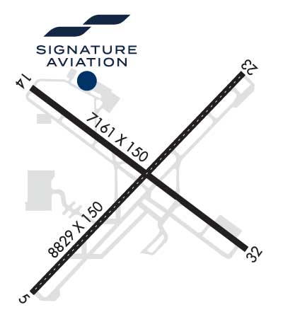
Runway Identifications Help
Runway Identification: 05/23 Length: 8829 ftWidth: 150 ftSurface: ASPHALT-GOOD CONDITIONEdge lights: High Intensity Treatment: GROOVEDWeight: PCN 81 /F/B/W/T Runway: 05 Runway: 23 Mag heading: 55° Mag heading: 235° Rwy Slope: .60% Up Rwy Slope: -.60% Down Approach: ILS Approach: ILS Pattern: Left Traffic Pattern: Left Traffic Markings: PRECISION INSTRUMENT Markings: PRECISION INSTRUMENT Marking Condition: GOOD Marking Condition: GOOD Arresting Dev: Arresting Dev: Lat & Long: N4255.9 W07844.5 Lat. & Long.: N4256.9 W07843.1 Elev: 674.1 ft. MSL Elev: 726.8 ft. MSL TCH: 49 ft. AGL TCH: 52 ft. AGL Visual Glide Path: 3.00 degrees Visual Glide Path: 3.00 degrees Displaced Threshold: 535 feet Displaced Threshold: 725 feet Touchdown Zone: YES Touchdown Zone: YES Touchdown Elev.: 707.5 feet Touchdown Elev.: 725.9 feet Visual Glide Slope: 4-Light PAPI on LEFT side of Runway Visual Glide Slope: 4-Light PAPI on RIGHT side of Runway RVR Equipment: TOUCHDOWN-MIDFIELD-ROLLOUT RVR Equipment: TOUCHDOWN-MIDFIELD-ROLLOUT RVV Equipment: NO RVV Equipment: NO Approach Lights: MALSR - 1,400 foot medium intensity approach lighting system with runway alignment indicator lights Approach Lights: ALSF2 - standard 2,400 foot high intensity approach lighting system with sequenced flashers, Category II or III REIL: NO REIL: NO Centerline Lights: YES Centerline Lights: YES Touchdown lights: YES Touchdown lights: YES Runway Category: Precision Instrument Runway Runway Category: Precision Instrument Runway Declared Distances: TORA:8829' TODA:8829' ASDA:8104' LDA:7569' Declared Distances: TORA:8829' TODA:8829' ASDA:8294' LDA:7569' Obstructions: BLDG Obstructions: TREE Marked: NOT Marked/Lighted Marked: NOT Marked/Lighted Clearance slope: 10:1; RWY 05 APCH SLOPE 45:1 TO DSPLCD THLD. Clearance slope: 32:1 Obstruction height: 21 feet AGL Obstruction height: 29 feet AGL Dist. from runway: 413 feet Dist. from runway: 1155 feet Centerline offset: 532 right of centerline Centerline offset: 360 feet right of centerline Comments: RWY 05 HAS +3 FT POLE LIGHT POLE 59 FT FM RWY END, 497 FT RIGHT. Comments:
Runway Identification: 14/32 Length: 7161 ftWidth: 150 ftSurface: ASPHALT-GOOD CONDITIONEdge lights: High Intensity Treatment: GROOVEDWeight: PCN 70 /F/B/W/T Runway: 14 Runway: 32 Mag heading: 138° Mag heading: 318° Rwy Slope: .14% Up Rwy Slope: -.14% Down Approach: Approach: ILS/DME Pattern: Left Traffic Pattern: Left Traffic Markings: NONPRECISION INSTRUMENT Markings: PRECISION INSTRUMENT Marking Condition: GOOD Marking Condition: GOOD Arresting Dev: Arresting Dev: Lat & Long: N4256.8 W07844.5 Lat. & Long.: N4256.1 W07843.2 Elev: 699.1 ft. MSL Elev: 708.8 ft. MSL TCH: 53 ft. AGL TCH: 54 ft. AGL Visual Glide Path: 3.00 degrees Visual Glide Path: 3.00 degrees Displaced Threshold: 320 feet Displaced Threshold: 720 feet Touchdown Zone: YES Touchdown Zone: YES Touchdown Elev.: 710.2 feet Touchdown Elev.: 713.2 feet Visual Glide Slope: 4-Light PAPI on LEFT side of Runway Visual Glide Slope: 4-Light PAPI on LEFT side of Runway RVR Equipment: RVR Equipment: RVV Equipment: NO RVV Equipment: NO Approach Lights: Approach Lights: MALSR - 1,400 foot medium intensity approach lighting system with runway alignment indicator lights REIL: YES REIL: NO Centerline Lights: NO Centerline Lights: NO Touchdown lights: NO Touchdown lights: NO Runway Category: Runway with a Non-precision Approach having visibility minimums greater than 3/4 mile Runway Category: Precision Instrument Runway Declared Distances: TORA:7161' TODA:7161' ASDA:6441' LDA:6121' Declared Distances: TORA:7161' TODA:7161' ASDA:6841' LDA:6121' Obstructions: TREE Obstructions: SIGN Marked: NOT Marked/Lighted Marked: NOT Marked/Lighted Clearance slope: 13:1; RWY 14 APCH SLOPE 29:1 TO DSPLCD THLD. Clearance slope: 1:1 Obstruction height: 31 feet AGL Obstruction height: 14 feet AGL Dist. from runway: 608 feet Dist. from runway: 200 feet Centerline offset: 535 right of centerline Centerline offset: 429 feet left of centerline Comments: Comments: +7 FT OBSTRUCTION LIGHTED FENCE , 0 FT FM RWY END, 480 FT LEFT.