KBTR

BATON ROUGE METROPOLITAN, RYAN
BATON ROUGE
LA
Time Zone: Central
Lat: N 3032.0
Long: W 09109.0
Elev: 70
Var: -00
Longest Runway: 7500
Clr Del: 119.4
Dept. ATIS: 125.2
Arr. ATIS: 125.2
Ground: 121.9
Tower: 118.45

FBO & Flight Services info for KBTR

FBOs: Update your Fuel Prices

BTR JET CENTERPh: 225-355-9052
-
Freq: 131.77
Service
Jet
100LL
SAF
MoGas
Fuel Avail: JET A INCLUDES PRIST. Mon - Fri 5am thru 10pm Sat - Sun 5am thru 10pm
Full7.508.34    Last Update: 04/21/2024 10:48

Exclusive CAA Member and Fuel Provider
Self        
 Address: 4490 BLANCHE NOYES   BATON ROUGE, LA 70807-5249
SIGNATUREPh: 225-356-1401
-
Freq: 129.3
Service
Jet
100LL
SAF
MoGas
Fuel Avail: Jet A w/Prist, add $0.08 per gallon. 5 a.m. - 10 p.m. M-F, after hours available upon request
Full7.458.00    Last Update: 04/25/2024 09:46

We now Accept World Fuel Contract!
Self        
 Address: 4303 CHUCK YEAGER AVE   BATON ROUGE, LA 70807-5251
ASOSPh: 225-356-2305
-
-
 
If you are an FBO, call 1-203-262-1700 to update your info or email: FltPlan.Advertising@garmin.com
Advertise your FBO on FltPlan.com
FBOs at nearby airports who want your business:
KHDC


  click here  
Pierce Aviation, (formerly known as Hammond Air Center), is a true FBO. We pride ourselves in offering personalized service and high-end amenities at a reasonable price. Our FBO is operated by professional pilots. We offer outstanding service and modern facilities. Come see what happens when a couple of pilots try their hand at building an FBO and actually pull it off!
Ph: 1-985-345-3030WebsiteE-MailFax: 1-985-249-2643Freq: 129.45

Runway & Approach Info for KBTR
Rwy
Length
Land Dist**
Approach*
  Rwy
Length
Land Dist**
Approach*
04L
7500x150  7500'          
 
  
22R
  7500x150  7500'          
ILS/DME
 108.70 - 223°  
04R
3799x75  3799'          
 
  
22L
  3799x75  3799'          
 
13
7005x150  6408'          
ILS/DME
 110.30 - 133°  
  
31
  7005x150  6691'          
 
 * only ILS, LOC, LDA, and SDF approaches to a specific runway are shown
** For any Declared Landing Distance Available, please see A/FD or Approach plates
Runway Weight Capability (lbs.) Help
Runway IDSingle WheelDouble WheelDouble Tandem WheelDual Double Wheel
04L/22R120,000170,000300,000N/A
04R/22L30,00045,000N/AN/A
13/31120,000170,000300,000N/A
These numbers are Advisory and are not limits.   The Airport Manager should have more accurate Weight Limits
Approach Charts
Approaches    
Current Weather/Notams
Customs Information Send updates to Support@FltPlan.com
Phone 225-389-0261
Fax 225-389-0260

Comments Mon-Fri 0800-1700 *2 hrs advance notice required *Call prior to 1430 on preceding weekday.
Database effective 05/16/2024
Airport Diagram of KBTR
Airport Diagram might not be current.

Facility Name: BATON ROUGE METRO, RYAN FLD
City Name: BATON ROUGE
County: EAST BATON ROUGE
State abbrev: LA
State Name: LOUISIANA
   
Ownership: PUBLICLY OWNED
Use: OPEN TO THE PUBLIC
Owner's Name: EAST BATON ROUGE PARISH; CITY OF BATON ROUGE AND PARISH OF EAST BATON ROUGE.
Address: PO BOX 1471
 BATON ROUGE, LA 70821
Owner's Phone:
  
Manager's Name: MIKE EDWARDS
Address: 9430 JACKIE COCHRAN DR. STE 300
 BATON ROUGE, LA 70807
Phone: 225-355-0333
   
FAA Region: SOUTHWEST
FAA Field Office: LNM
2006 Earthcrawl Photography www.earthcrawl.com


Click here for full scale & interactive Sectional view of KBTR


Sunrise / Sunset times for BATON ROUGE METRO, RYAN FLD

DateSunriseSunset
04/24/24 Wednesday6:2719:39
04/25/24 Thursday6:2619:39
04/26/24 Friday6:2519:40
04/27/24 Saturday6:2419:41
04/28/24 Sunday6:2319:41
04/29/24 Monday6:2219:42
04/30/24 Tuesday6:2119:43
05/01/24 Wednesday6:2019:43
05/02/24 Thursday6:1919:44
05/03/24 Friday6:1919:45
05/04/24 Saturday6:1819:45
05/05/24 Sunday6:1719:46
05/06/24 Monday6:1619:47
05/07/24 Tuesday6:1519:47

Airport Facilities

Airport Attendance Schedule7 Days A Week 0500-0000
Airport Status OPERATIONAL (This Status can change at any time - please check NOTAMS)
Airport Lighting ScheduleACTVT MALSR RYS 22R & 13 AND MALS RY 31 - CTAF. WHEN ATCT CLSD HIRL RYS 13/31 & 04L/22R PRESET LOW INTST; TO INCR INTST ACTVT - CTAF. MIRL RY 04R/22L NOT AVBL.
Airport Storage AvailableTie Downs, Hanger
Extra Services AvailableAir Freight, Avionics, Cargo Handling, Charter, Flight Instruction, Aircraft Rental, Aircraft Sales
Wind IndicatorYES - (lighted)
Control TowerYES
CTAF Frequency118.450
Unicom Frequency122.950
Rotating Beacon ColorWG
Segmented CircleYES
Landing FeeNO

Airport Inspection Data

Airport InspectedFEDERAL - performed by FAA AIRPORTS FIELD PERSONNEL
Inspection Date07/13/2023

Airport Services

Type of Fuel AvailableGrade 100LL, JET A (freeze point -40C)
Airframe Repair ServiceMAJOR
Power Plant Repair ServiceMAJOR

Geographic Data

LatitudeN3032.0
LongitudeW09109.0 (ESTIMATED)
Arpt Elevation69ft (SURVEYED)
Magnetic Variation00E
4 miles Nof BATON ROUGE
Traffic Pattern Altitude
Sectional ChartHOUSTON

Aircraft Data

Operations (Reported)YearlyAvg. Daily
General Aviation Transient 1725547
General Aviation Local 1492941
Air Taxi 721320
Commerical 862924
Commuter 00
Military 14694
Aircraft based on Field
General Aviation Singles 98
General Aviation Multi 28
Jet Aircraft 27
General Aviation Helicopters 17
Military Aircraft 0
Gliders 0
Ultralights 0

FAA Services

FSS on field NO
FSS tie-in DE RIDDER
FSS Phone 1-800-WX-BRIEF
Who issues Notams BTR
Notam D service at airport YES
ARTCC Name HOUSTON

Federal Status

Airport CertificationAIRPORT RECEIVING SCHEDULED AIR CARRIER SERVICE FROM CARRIERS CERTIFICATED BY THE CIVIL AERONAUTICS BOARD; 24 HRS PPR FOR UNSKED ACR OPNS WITH MORE THAN 30 PSGR SEATS 0000-0500 CALL AMGR 225-355-2068/0333.
Aircraft Rescue & Firefighting IndexAIRPORT HAS A CERTIFICATE UNDER CFR PART 139
Airport of EntryNo
Custom Landing RightsYES
Joint Civil/MilitaryNo
Military Landing rightsYES

Federal Agreements

NATIONAL PLAN OF INTEGRATED AIRPORT SYSTEMS (NPIAS)
GRANT AGREEMENTS UNDER FAAP/ADAP/AIP
SURPLUS PROPERTY AGREEMENT UNDER PUBLIC LAW 289
ASSURANCES PURSUANT TO TITLE VI, CIVIL RIGHTS ACT OF 1964
AGREEMENT UNDER DLAND OR DCLA HAS EXPIRED.

Remarks

WHEN ATCT CLSD USE FREQ 121.9 TO CTC ARFF FOR EMERG REQ.
FOR CD IF UNA TO CTC ON FSS FREQ, CTC HOUSTON ARTCC AT 281-230-5622.
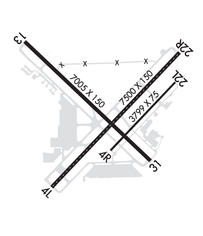
TWY E, TWY F BTN RWY 04R-22L AND AER 31 NOT AVBL FOR SKEDD ACR OPS.
TWY F BTN RWY 04R-22L AND AER 31 RDCS TO 40 FT WID.
MIGRATORY BIRDS ON & INVOF ARPT DURING MONTHS OF MAR/APR/SEP & OCT.
TWY E WEIGHT RESTRICTIONS: SINGLE 44,000 LBS; DUAL 55,000 LBS; DUAL TANDEM 93,000 LBS.
RAMP & TWY LANE ADJ TO THE COMMERICAL AIR CARRIER TERMINAL BLDG IS LMTD TO COMMERICAL AIR CARRIER AND PSGR AIRTAXI ACFT ONLY.
RWY 04R/22L NOT AVBL FOR ACR OPNS WITH MORE THAN 30 PSGR SEATS.
RWY 4R/22L AND TWY E ARE SIMILAR IN APPRNC. USE CTN WHEN EXITING RWY 13/31.
Airport Communications & Frequencies:
ATIS Frequencies:   Hours(local) of Operation: CONTINUOUS
125.2
RYAN Tower Frequencies:   Hours(local) of operation: 0500-0000   
118.45
257.8
RYAN Ground Frequencies:
121.9
Clearance Delivery Frequencies:
119.4
Emergency Frequencies:
121.5
243.0
CTAF Frequency:
118.450
Unicom Frequency:
122.950
Remarks
  • APCH/DEP SVC PRVDD BY HOUSTON ARTCC (ZHU) ON FREQS 126.35/338.25 (LACOMBE RCAG) WHEN BATON ROUGE (BTR) APCH CTL CLSD.
  • BATON ROUGE Primary Approach Frequencies:   Hours(local) of operation: 0500-0000   
    120.3 ;WEST
    133.225 ;EAST
    278.3
    BATON ROUGE Primary Departure Frequencies:   Hours(local) of operation: 0500-0000   
    120.3 ;WEST
    133.225 ;EAST
    278.3
    Class C Frequencies:
    120.3 ;WEST
    133.225 ;EAST
    278.3
    Runway Identifications
    Runway Identification: 04L/22R
    Length: 7500 ft
    Width: 150 ft
    Surface: CONCRETE
    Edge lights: High Intensity

    Treatment: GROOVED
    Weight: PCN 70 /R/A/W/T

     Runway: 04L   Runway: 22R
    Mag heading: 43°Mag heading: 223°
    Rwy Slope: .05% UpRwy Slope: -.05% Down
    Approach: Approach: ILS/DME
    Pattern: Left TrafficPattern: Right Traffic
    Markings: NONPRECISION INSTRUMENTMarkings: PRECISION INSTRUMENT
    Marking Condition: GOODMarking Condition: GOOD
    Arresting Dev: Arresting Dev:
    Lat & Long: N3031.5  W09109.4Lat. & Long.: N3032.4  W09108.5
    Elev: 65.4 ft. MSLElev: 69.3 ft. MSL
    TCH: TCH: 56 ft. AGL
    Visual Glide Path: Visual Glide Path: 3.00 degrees
    Displaced Threshold: NoDisplaced Threshold: No
    Touchdown Zone: YESTouchdown Zone: YES
    Touchdown Elev.: 68.9 feetTouchdown Elev.: 69.7 feet
    Visual Glide Slope: Visual Glide Slope: 4-Light PAPI on LEFT side of Runway
    RVR Equipment: TOUCHDOWN-ROLLOUTRVR Equipment: TOUCHDOWN-ROLLOUT
    RVV Equipment: NORVV Equipment: NO
    Approach Lights: Approach Lights: MALSR - 1,400 foot medium intensity approach lighting system with runway alignment indicator lights
    REIL: NOREIL: NO
    Centerline Lights: YESCenterline Lights: YES
    Touchdown lights: NOTouchdown lights: YES
    Runway Category: Runway with a Non-precision Approach having visibility minimums greater than 3/4 mileRunway Category: Precision Instrument Runway
    Declared Distances: TORA:7500' TODA:7500' ASDA:7500' LDA:7500'Declared Distances: TORA:7500' TODA:7500' ASDA:7500' LDA:7500'
    Obstructions: POLEObstructions:
    Marked: LIGHTEDMarked:
    Clearance slope: 38:1Clearance slope: 50:1
    Obstruction height: 52 feet AGLObstruction height:
    Dist. from runway: 2200 feetDist. from runway:
    Centerline offset: 125 left of centerlineCenterline offset:
    Comments: Comments:
    Runway Identification: 04R/22L
    Length: 3799 ft
    Width: 75 ft
    Surface: ASPHALT-FAIR CONDITION
    Edge lights: Medium Intensity

    Treatment: NONE
    Weight: PCN 26 /F/C/X/T

     Runway: 04R   Runway: 22L
    Mag heading: 43°Mag heading: 223°
    Rwy Slope: .05% UpRwy Slope: -.05% Down
    Approach: Approach:
    Pattern: Right TrafficPattern: Left Traffic
    Markings: BASICMarkings: BASIC
    Marking Condition: GOODMarking Condition: GOOD
    Arresting Dev: Arresting Dev:
    Lat & Long: N3031.7  W09109.0Lat. & Long.: N3032.2  W09108.5
    Elev: 66.5 ft. MSLElev: 68.3 ft. MSL
    TCH: TCH:
    Visual Glide Path: Visual Glide Path:
    Displaced Threshold: NoDisplaced Threshold: No
    Touchdown Zone: YESTouchdown Zone: YES
    Touchdown Elev.: 68.9 feetTouchdown Elev.: 68.9 feet
    Visual Glide Slope: Visual Glide Slope:
    RVR Equipment: RVR Equipment:
    RVV Equipment: NORVV Equipment: NO
    Approach Lights: Approach Lights:
    REIL: NOREIL: NO
    Centerline Lights: NOCenterline Lights: NO
    Touchdown lights: NOTouchdown lights: NO
    Runway Category: Runway with a Visual ApproachRunway Category: Runway with a Visual Approach
    Declared Distances: TORA:3799' TODA:3799' ASDA:3799' LDA:3799'Declared Distances: TORA:3799' TODA:3799' ASDA:3799' LDA:3799'
    Runway Identification: 13/31
    Length: 7005 ft
    Width: 150 ft
    Surface: ASPHALT-GOOD CONDITION
    Edge lights: High Intensity

    Treatment: GROOVED
    Weight: PCN 95 /F/C/X/T

     Runway: 13   Runway: 31
    Mag heading: 133°Mag heading: 313°
    Rwy Slope: .04% UpRwy Slope: -.04% Down
    Approach: ILS/DMEApproach:
    Pattern: Left TrafficPattern: Left Traffic
    Markings: PRECISION INSTRUMENTMarkings: NONPRECISION INSTRUMENT
    Marking Condition: GOODMarking Condition: GOOD
    Arresting Dev: Arresting Dev:
    Lat & Long: N3032.4  W09109.7Lat. & Long.: N3031.6  W09108.7
    Elev: 65.9 ft. MSLElev: 69.0 ft. MSL
    TCH: TCH: 64 ft. AGL
    Visual Glide Path: Visual Glide Path: 3.00 degrees
    Displaced Threshold: 597 feetDisplaced Threshold: 314 feet
    Touchdown Zone: YESTouchdown Zone: YES
    Touchdown Elev.: 66.8 feetTouchdown Elev.: 69.0 feet
    Visual Glide Slope: Visual Glide Slope: 4-BOX VASI ON LEFT SIDE OF RUNWAY
    RVR Equipment: TOUCHDOWNRVR Equipment: ROLLOUT
    RVV Equipment: NORVV Equipment: NO
    Approach Lights: MALSR - 1,400 foot medium intensity approach lighting system with runway alignment indicator lightsApproach Lights: MALS - 1,400 foot medium intensity approach lighting system
    REIL: NOREIL: NO
    Centerline Lights: NOCenterline Lights: NO
    Touchdown lights: NOTouchdown lights: NO
    Runway Category: Precision Instrument RunwayRunway Category: D
    Declared Distances: TORA:7004' TODA:7004' ASDA:6317' LDA:5720'Declared Distances: TORA:7004' TODA:7004' ASDA:6407' LDA:6094'
    Obstructions: POLEObstructions: ROAD
    Marked: LIGHTEDMarked: NOT Marked/Lighted
    Clearance slope: 28:1Clearance slope: 2:1; +68 FT TREE, 1578 FT, 516 RIGHT.
    Obstruction height: 76 feet AGLObstruction height: 11 feet AGL
    Dist. from runway: 2345 feetDist. from runway: 230 feet
    Centerline offset: 103 right of centerlineCenterline offset: 503 feet right of centerline
    Comments: +7 FT FENCE 200 FT 406 FT LEFT.Comments: +7 FT FENCE 200 FT 496 FT RIGHT.
    C:165/P: