Click here for more info on on SMS!

KBTL

W K KELLOGG
BATTLE CREEK
MI
Time Zone: Eastern
Lat: N 4218.4
Long: W 08515.0
Elev: 952
Var: +04
Longest Runway: 10004
Dept. ATIS: 128.32
Arr. ATIS: 128.32
Ground: 121.7
Tower: 126.82

FBO & Flight Services info for KBTL

FBOs: Update your Fuel Prices

DUNCAN AVIATIONPh: 800-525-2376 Fax: 269-969-8432 Freq: 122.95
Service
Jet
100LL
SAF
MoGas
Fuel Avail: ~~
Full        Last Update: 04/19/2024 00:01:45

Self        
 Address: 15745 S AIRPORT RD,   BATTLE CREEK, MI 49015
CENTENNIAL ACFTPh: 269-565-1000 Fax: 269-565-1100 Freq: 122.95
Service
Jet
100LL
SAF
MoGas
Fuel Avail: PRIST+$0.10/gal 100LL self serve 24 hours, jet 8-17:00 M-F, On Call from 17:00 - 22:00 M-F
Full5.756.69    Caution: Fuel prices have not been updated in 32 days.
Last Update: 03/18/2024 09:56

Self  6.19    
 Address: 2850 TERRITORIAL RD W,   BATTLE CREEK, MI 49015
ASOSPh: 269-964-0283
-
-
 
If you are an FBO, call 1-203-262-1700 to update your info or email: FltPlan.Advertising@garmin.com
Advertise your FBO on FltPlan.com

Runway & Approach Info for KBTL
Rwy
Length
Land Dist**
Approach*
  Rwy
Length
Land Dist**
Approach*
05L
10004x150  10004'          
 
  
23R
  10004x150  10004'          
ILS
 110.50 - 226°  
05R
4100x75  4100'          
 
  
23L
  4100x75  4100'          
 
13
4835x100  4835'          
 
  
31
  4835x100  4835'          
 
 * only ILS, LOC, LDA, and SDF approaches to a specific runway are shown
** For any Declared Landing Distance Available, please see A/FD or Approach plates
Runway Weight Capability (lbs.) Help
Runway IDSingle WheelDouble WheelDouble Tandem WheelDual Double Wheel
05L/23R100,000200,000400,000900,000
05R/23L12,500N/AN/AN/A
13/3140,00065,000100,000N/A
These numbers are Advisory and are not limits.   The Airport Manager should have more accurate Weight Limits
Approach Charts
Approaches    
Current Weather/Notams
Customs Information Send updates to Support@FltPlan.com
Phone 269-965-3349
Fax 269-965-0661

Comments On call basis. 2 hrs advance notice required. Business hrs 0800-1600 Monday-Friday. *Maximum passengers per flight: 10 *Call prior to 1700 on preceding weekday.
Database effective 04/18/2024
Airport Diagram of KBTL
Airport Diagram might not be current.

Facility Name: BATTLE CREEK EXEC AT KELLOGG FLD
City Name: BATTLE CREEK
County: CALHOUN
State abbrev: MI
State Name: MICHIGAN
   
Ownership: PUBLICLY OWNED
Use: OPEN TO THE PUBLIC
Owner's Name: CITY OF BATTLE CREEK
Address: 15551 SOUTH AIRPORT RD
 BATTLE CREEK, MI 49015-7644
Owner's Phone: 269-966-3470
  
Manager's Name: PHILIP KROLL
Address: 15551 SOUTH AIRPORT RD
 BATTLE CREEK, MI 49015-7644
Phone: 269-966-3470
   
FAA Region: GREAT LAKES
FAA Field Office: DET


Sunrise / Sunset times for BATTLE CREEK EXEC AT KELLOGG FLD

DateSunriseSunset
04/18/24 Thursday6:5420:27
04/19/24 Friday6:5320:28
04/20/24 Saturday6:5120:29
04/21/24 Sunday6:5020:30
04/22/24 Monday6:4820:31
04/23/24 Tuesday6:4720:32
04/24/24 Wednesday6:4520:34
04/25/24 Thursday6:4420:35
04/26/24 Friday6:4220:36
04/27/24 Saturday6:4120:37
04/28/24 Sunday6:3920:38
04/29/24 Monday6:3820:39
04/30/24 Tuesday6:3720:40
05/01/24 Wednesday6:3520:41

Airport Facilities

Airport Attendance ScheduleCONTINUOUS
Airport Status OPERATIONAL (This Status can change at any time - please check NOTAMS)
Airport Lighting ScheduleWHEN ATCT CLSD ACTVT MALSR RWY 23R; REIL RWY 05L, 05R, 23L, 13, & 31; PAPI RWY 05L, 23R, 05R, 23L, 13, & 31; HIRL RWY 05L/23R; MIRL RWY 05R/23L & 13/31 - CTAF.
Airport Storage AvailableTie Downs, Hanger
Extra Services AvailableAir Freight, Avionics, Charter, Flight Instruction, Aircraft Rental, Aircraft Sales
Wind IndicatorYES - (lighted)
Control TowerYES
CTAF Frequency126.825
Unicom Frequency122.950
Rotating Beacon ColorWG
Segmented CircleYES
Landing FeeYES

Airport Inspection Data

Airport InspectedFEDERAL - performed by FAA AIRPORTS FIELD PERSONNEL
Inspection Date12/10/2021

Airport Services

Type of Fuel AvailableGrade 100LL, JET A
Airframe Repair ServiceMAJOR
Power Plant Repair ServiceMAJOR

Geographic Data

LatitudeN4218.4
LongitudeW08515.0 (ESTIMATED)
Arpt Elevation951ft (SURVEYED)
Magnetic Variation04W
3 miles Wof BATTLE CREEK
Traffic Pattern Altitude
Sectional ChartCHICAGO

Aircraft Data

Operations (Reported)YearlyAvg. Daily
General Aviation Transient 1278035
General Aviation Local 52480144
Air Taxi 2979182
Commerical 250
Commuter 00
Military 10503
Aircraft based on Field
General Aviation Singles 71
General Aviation Multi 16
Jet Aircraft 2
General Aviation Helicopters 0
Military Aircraft 0
Gliders 0
Ultralights 0

FAA Services

FSS on field NO
FSS tie-in LANSING
FSS Phone 1-800-WX-BRIEF
Who issues Notams BTL
Notam D service at airport YES
ARTCC Name CHICAGO

Federal Status

Airport Certification
Aircraft Rescue & Firefighting IndexNone
Airport of EntryNo
Custom Landing RightsYES
Joint Civil/MilitaryNo
Military Landing rightsYES

Federal Agreements

NATIONAL PLAN OF INTEGRATED AIRPORT SYSTEMS (NPIAS)
GRANT AGREEMENTS UNDER FAAP/ADAP/AIP
SURPLUS PROPERTY AGREEMENT UNDER PUBLIC LAW 289
CONVEYANCE UNDER SCETION 16, FEDERAL AIRPORT ACT OF 1946 OR SECTION 23, AIRPORT AND AIRWAY DEVELOPMENT ACT OF 1970
ASSURANCES PURSUANT TO TITLE VI, CIVIL RIGHTS ACT OF 1964

Remarks

DEER & BIRDS ON & INVOF ARPT.
MILITARY: ANG: BASH LEVELS AS DEFINED IN AFI 91-202.
MILITARY: ANG: APN/TWY USBL ONLY O/R, OTRW CLSD - COORD WITH 110TH WING SAFETY AT C269-969-3438.
EXTSV PILOT TRG WI 25 NM OF ARPT.
ARPT FICON MNTD WKDAYS 0700-1530; NOT MNTD ALL OTR TIMES.
SNOW REMOVAL OPS INPR DRG WINTER MONTHS; EQPT OPRS MNT CTAF WHEN ATCT CLSD.
24 HRS PN FOR CUST, CALL 269-965-3349.
MOWING OPS INPR MAR-OCT.
FOR CD WHEN ATCT CLSD CTC GREAT LAKES APCH AT 269-459-3344, WHEN APCH CLSD CTC CHICAGO ARTCC AT 630-906-8921.
VOLUNTARY NOISE ABATEMENT PROCS IN EFCT. SEE FLY QUIET PROGRAM AT WWW.FLYBTL.COM.
TWY F RSTRD TO DOD/MIL USE ONLY.
Airport Communications & Frequencies:
ATIS Frequencies:   Hours(local) of Operation:
128.325
BATTLE CREEK Tower Frequencies:   Hours(local) of operation: 0700-2300   
126.825
BATTLE CREEK Ground Frequencies:
121.7
Emergency Frequencies:
243.0
CTAF Frequency:
126.825
Unicom Frequency:
122.950
Remarks
  • APCH/DEP SVC PRVDD BY CHICAGO ARTCC ON 127.55/307.175 (GOSHEN RCAG) WHEN GREAT LAKES APCH CTL CLSD.
  • GREAT LAKES Primary Approach Frequencies:  
    119.2
    239.25
    GREAT LAKES Primary Departure Frequencies:  
    119.2
    239.25
    Runway Identifications
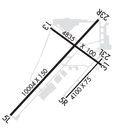
    Runway Identification: 05L/23R
    Length: 10004 ft
    Width: 150 ft
    Surface: ASPHALT-GOOD CONDITION
    Edge lights: High Intensity

    Treatment: GROOVED
    Weight: PCN 27 /F/B/X/T

     Runway: 05L   Runway: 23R
    Mag heading: 47°Mag heading: 227°
    Rwy Slope: -.23% DownRwy Slope: .23% Up
    Approach: Approach: ILS
    Pattern: Left TrafficPattern: Left Traffic; RIGHT TFC WHEN TWR CLSD.
    Markings: NONPRECISION INSTRUMENTMarkings: PRECISION INSTRUMENT
    Marking Condition: GOODMarking Condition: GOOD
    Arresting Dev: Arresting Dev:
    Lat & Long: N4217.7  W08516.0Lat. & Long.: N4219.0  W08514.5
    Elev: 951.8 ft. MSLElev: 928.4 ft. MSL
    TCH: 48 ft. AGLTCH: 49 ft. AGL
    Visual Glide Path: 3.00 degreesVisual Glide Path: 3.00 degrees
    Displaced Threshold: NoDisplaced Threshold: No
    Touchdown Zone: YESTouchdown Zone: YES
    Touchdown Elev.: 951.8 feetTouchdown Elev.: 928.8 feet
    Visual Glide Slope: 4-Light PAPI on LEFT side of RunwayVisual Glide Slope: 4-Light PAPI on LEFT side of Runway
    RVR Equipment: ROLLOUTRVR Equipment: TOUCHDOWN
    RVV Equipment: NORVV Equipment: YES
    Approach Lights: Approach Lights: MALSR - 1,400 foot medium intensity approach lighting system with runway alignment indicator lights
    REIL: YESREIL: NO
    Centerline Lights: NOCenterline Lights: NO
    Touchdown lights: NOTouchdown lights: NO
    Runway Category: Runway with a Non-precision Approach having visibility minimums greater than 3/4 mileRunway Category: Precision Instrument Runway
    Declared Distances: TORA:10004' TODA:10004' ASDA:10004' LDA:10004'Declared Distances: TORA:10004' TODA:10004' ASDA:10004' LDA:10004'
    Obstructions: Obstructions: POLE
    Marked: Marked: LIGHTED
    Clearance slope: 50:1Clearance slope: 43:1
    Obstruction height: Obstruction height: 19 feet AGL
    Dist. from runway: Dist. from runway: 1033 feet
    Centerline offset: Centerline offset: 288 feet right of centerline
    Comments: Comments:
    Runway Identification: 05R/23L
    Length: 4100 ft
    Width: 75 ft
    Surface: ASPHALT
    Edge lights: Medium Intensity

    Treatment: NONE
    Weight: PCN 13 /F/C/X/T

     Runway: 05R   Runway: 23L
    Mag heading: 47°Mag heading: 227°
    Rwy Slope: .12% UpRwy Slope: -.12% Down
    Approach: Approach:
    Pattern: Left Traffic; RIGHT TFC WHEN TWR CLSD.Pattern: Left Traffic
    Markings: NONPRECISION INSTRUMENTMarkings: NONPRECISION INSTRUMENT
    Marking Condition: GOODMarking Condition: GOOD
    Arresting Dev: Arresting Dev:
    Lat & Long: N4218.0  W08515.0Lat. & Long.: N4218.5  W08514.4
    Elev: 925.0 ft. MSLElev: 930.0 ft. MSL
    TCH: 25 ft. AGLTCH: 30 ft. AGL
    Visual Glide Path: 3.00 degreesVisual Glide Path: 3.00 degrees
    Displaced Threshold: NoDisplaced Threshold: No
    Touchdown Zone: YESTouchdown Zone: YES
    Touchdown Elev.: 926.9 feetTouchdown Elev.: 930.0 feet
    Visual Glide Slope: 4-Light PAPI on LEFT side of RunwayVisual Glide Slope: 4-Light PAPI on LEFT side of Runway
    RVR Equipment: RVR Equipment:
    RVV Equipment: NORVV Equipment: NO
    Approach Lights: Approach Lights:
    REIL: YESREIL: YES
    Centerline Lights: NOCenterline Lights: NO
    Touchdown lights: NOTouchdown lights: NO
    Runway Category: Runway with a Visual ApproachRunway Category: Runway with a Visual Approach
    Declared Distances: TORA:4100' TODA:4100' ASDA:4100' LDA:4100'Declared Distances: TORA:4100' TODA:4100' ASDA:4100' LDA:4100'
    Runway Identification: 13/31
    Length: 4835 ft
    Width: 100 ft
    Surface: ASPHALT-GOOD CONDITION
    Edge lights: Medium Intensity

    Treatment: GROOVED
    Weight: PCN 15 /F/C/X/T

     Runway: 13   Runway: 31
    Mag heading: 130°Mag heading: 310°
    Rwy Slope: .20% UpRwy Slope: -.20% Down
    Approach: Approach:
    Pattern: Left TrafficPattern: Left Traffic
    Markings: NONPRECISION INSTRUMENTMarkings: NONPRECISION INSTRUMENT
    Marking Condition: GOODMarking Condition: GOOD
    Arresting Dev: Arresting Dev:
    Lat & Long: N4218.9  W08515.3Lat. & Long.: N4218.4  W08514.4
    Elev: 919.8 ft. MSLElev: 929.4 ft. MSL
    TCH: 42 ft. AGLTCH: 25 ft. AGL
    Visual Glide Path: 3.00 degreesVisual Glide Path: 3.00 degrees
    Displaced Threshold: NoDisplaced Threshold: No
    Touchdown Zone: YESTouchdown Zone: YES
    Touchdown Elev.: 926.5 feetTouchdown Elev.: 930.1 feet
    Visual Glide Slope: 4-Light PAPI on LEFT side of RunwayVisual Glide Slope: 4-Light PAPI on LEFT side of Runway
    RVR Equipment: RVR Equipment:
    RVV Equipment: NORVV Equipment: NO
    Approach Lights: Approach Lights:
    REIL: YESREIL: YES
    Centerline Lights: NOCenterline Lights: NO
    Touchdown lights: NOTouchdown lights: NO
    Runway Category: Runway with a Visual ApproachRunway Category: Runway with a Non-precision Approach having visibility minimums greater than 3/4 mile
    Declared Distances: TORA:4835' TODA:4835' ASDA:4835' LDA:4835'Declared Distances: TORA:4835' TODA:4835' ASDA:4835' LDA:4835'
    Obstructions: RRObstructions: ROAD
    Marked: NOT Marked/LightedMarked: NOT Marked/Lighted
    Clearance slope: 20:1Clearance slope: 22:1
    Obstruction height: 20 feet AGLObstruction height: 15 feet AGL
    Dist. from runway: 601 feetDist. from runway: 530 feet
    Centerline offset: 281 right of centerlineCenterline offset: 6 feet right of centerline
    Comments: Comments:
    C:23/P: