Approach Charts
| FltPlan does not have IFR approach charts available for KBTF. |
Current Weather/Notams (Metars, TAFs, Notams, NWS Forecast, PIREPS, and nearby weather)
Customs Information Send updates to Support@FltPlan.com
Customs Not Available
Database effective 05/16/2024
Airport Diagram might not be current.
|
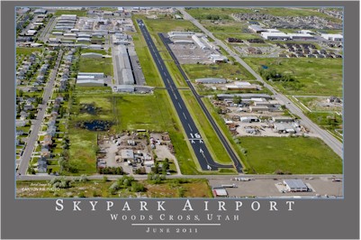
| Facility Name: | SKYPARK |
| City Name: | BOUNTIFUL |
| County: | DAVIS |
| State abbrev: | UT |
| State Name: | UTAH |
| | |
| Ownership: | PRIVATELY OWNED |
| Use: | OPEN TO THE PUBLIC |
| Owner's Name: | SKYPARK AIRPORT ASSOC, LLC |
| Address: | 1887 S. 1800 W. #2 |
| | WOODS CROSS, UT 84087 |
| Owner's Phone: | 801-295-3877 |
| | |
| Manager's Name: | CHRIX VOLZER |
| Address: | 1887 S. 1800 W., #2 |
| | WOODS CROSS, UT 84087 |
| Phone: | 801-295-3877 |
| | |
| FAA Region: | NORTHWEST MOUNTAIN |
| FAA Field Office: | DEN |
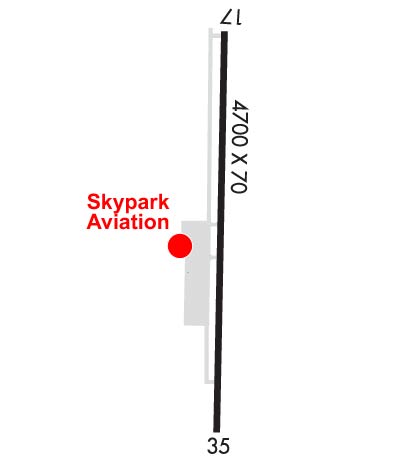
Runway Identifications
Runway Identification: 17/35Length: 4634 ft
Width: 70 ft
Surface: ASPHALT
Edge lights: Low IntensityTreatment: NONE
| | Runway: 17 | | Runway: 35 |
| Mag heading: | N/A | Mag heading: | N/A |
| Rwy Slope: | .02% Up | Rwy Slope: | -.02% Down |
| Approach: | | Approach: | |
| Pattern: | Left Traffic | Pattern: | Right Traffic |
| Markings: | BASIC | Markings: | BASIC |
| Marking Condition: | GOOD | Marking Condition: | GOOD |
| Arresting Dev: | | Arresting Dev: | |
| Lat & Long: | N4052.5 W11155.7 | Lat. & Long.: | N4051.7 W11155.6 |
| Elev: | 4236.1 ft. MSL | Elev: | 4237.1 ft. MSL |
| TCH: | 42 ft. AGL | TCH: | 42 ft. AGL |
| Visual Glide Path: | 3.50 degrees | Visual Glide Path: | 3.50 degrees |
| Displaced Threshold: | 389 feet | Displaced Threshold: | 391 feet |
| Touchdown Zone: | NO | Touchdown Zone: | NO |
| Touchdown Elev.: | | Touchdown Elev.: | |
| Visual Glide Slope: | 2-Light PAPI on LEFT side of Runway | Visual Glide Slope: | 2-Light PAPI on LEFT side of Runway |
| RVR Equipment: | | RVR Equipment: | |
| RVV Equipment: | NO | RVV Equipment: | NO |
| Approach Lights: | | Approach Lights: | |
| REIL: | NO | REIL: | NO |
| Centerline Lights: | NO | Centerline Lights: | NO |
| Touchdown lights: | NO | Touchdown lights: | NO |
| Runway Category: | Runway with a Visual Approach | Runway Category: | Runway with a Visual Approach |
| Declared Distances: | | Declared Distances: | |
| Obstructions: | FENCE | Obstructions: | FENCE |
| Marked: | NOT Marked/Lighted | Marked: | NOT Marked/Lighted |
| Clearance slope: | 4:1; APCH SLOPE 11:1 TO DTHR OVR 8 FT BLDG, 90 FT DSTC, 128 FT L. | Clearance slope: | CTLG OBSTN EXCEEDS A 45 DEG SLP. |
| Obstruction height: | 8 feet AGL | Obstruction height: | 6 feet AGL |
| Dist. from runway: | 232 feet | Dist. from runway: | 200 feet |
| Centerline offset: | | Centerline offset: | 90 feet left of centerline |
| Comments: | | Comments: | 6 FT FENCE, 0-90 FT DSTCM 94 FT R. |