Current Weather/Notams (Metars, TAFs, Notams, NWS Forecast, PIREPS, and nearby weather)
Customs Information Send updates to Support@FltPlan.com
Customs Not Available
Database effective 05/16/2024
Airport Diagram might not be current.
|
| Facility Name: | SAMUELS FLD |
| City Name: | BARDSTOWN |
| County: | NELSON |
| State abbrev: | KY |
| State Name: | KENTUCKY |
| | |
| Ownership: | PUBLICLY OWNED |
| Use: | OPEN TO THE PUBLIC |
| Owner's Name: | BARDSTOWN/NELSON CO ARPT BOARD; DAVID MATTINGLY |
| Address: | 1924 BOSTON ROAD |
| | BARDSTOWN, KY 40004 |
| Owner's Phone: | 502-827-0356 |
| | |
| Manager's Name: | TOM VERNON |
| Address: | 1924 BOSTON ROAD |
| | BARDSTOWN, KY 40004 |
| Phone: | 502-348-7858 |
| | |
| FAA Region: | SOUTHERN |
| FAA Field Office: | MEM |
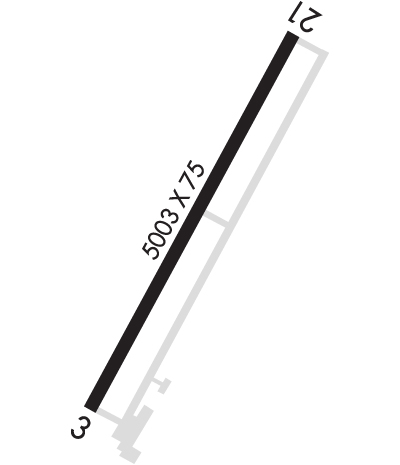
Runway Identifications
Runway Identification: 03/21Length: 5003 ft
Width: 75 ft
Surface: ASPHALT-GOOD CONDITION
Edge lights: Medium IntensityTreatment: NONE
Weight: PCN 12 /F/C/W/T
| | Runway: 03 | | Runway: 21 |
| Mag heading: | 27° | Mag heading: | 207° |
| Rwy Slope: | .68% Up | Rwy Slope: | -.68% Down |
| Approach: | | Approach: | |
| Pattern: | Left Traffic | Pattern: | Left Traffic |
| Markings: | NONPRECISION INSTRUMENT | Markings: | NONPRECISION INSTRUMENT |
| Marking Condition: | GOOD | Marking Condition: | GOOD |
| Arresting Dev: | | Arresting Dev: | |
| Lat & Long: | N3748.5 W08530.2 | Lat. & Long.: | N3749.2 W08529.8 |
| Elev: | 634.9 ft. MSL | Elev: | 668.7 ft. MSL |
| TCH: | 41 ft. AGL | TCH: | 28 ft. AGL |
| Visual Glide Path: | 3.50 degrees | Visual Glide Path: | 3.00 degrees |
| Displaced Threshold: | No | Displaced Threshold: | No |
| Touchdown Zone: | YES | Touchdown Zone: | YES |
| Touchdown Elev.: | 654.7 feet | Touchdown Elev.: | 668.8 feet |
| Visual Glide Slope: | 2-Light PAPI on LEFT side of Runway | Visual Glide Slope: | 2-Light PAPI on LEFT side of Runway |
| RVR Equipment: | | RVR Equipment: | |
| RVV Equipment: | NO | RVV Equipment: | NO |
| Approach Lights: | | Approach Lights: | |
| REIL: | YES | REIL: | YES |
| Centerline Lights: | NO | Centerline Lights: | NO |
| Touchdown lights: | NO | Touchdown lights: | NO |
| Runway Category: | Runway with a Non-precision Approach having visibility minimums greater than 3/4 mile | Runway Category: | Runway with a Non-precision Approach having visibility minimums greater than 3/4 mile |
| Declared Distances: | | Declared Distances: | |
| Obstructions: | POLE | Obstructions: | TREE |
| Marked: | NOT Marked/Lighted | Marked: | NOT Marked/Lighted |
| Clearance slope: | 4:1 | Clearance slope: | 31:1 |
| Obstruction height: | 11 feet AGL | Obstruction height: | 68 feet AGL |
| Dist. from runway: | 251 feet | Dist. from runway: | 2339 feet |
| Centerline offset: | 251 right of centerline | Centerline offset: | 343 feet right of centerline |
| Comments: | | Comments: | |

