Current Weather/Notams (Metars, TAFs, Notams, NWS Forecast, PIREPS, and nearby weather)
Customs Information Send updates to Support@FltPlan.com
Customs Not Available
Database effective 04/18/2024
Airport Diagram might not be current.
|
| Facility Name: | SOUTHEAST IOWA RGNL |
| City Name: | BURLINGTON |
| County: | DES MOINES |
| State abbrev: | IA |
| State Name: | IOWA |
| | |
| Ownership: | PUBLICLY OWNED |
| Use: | OPEN TO THE PUBLIC |
| Owner's Name: | SE IOWA REG ARPT AUTHORITY |
| Address: | 2515 SUMMER STREET |
| | BURLINGTON, IA 52601-3330 |
| Owner's Phone: | 319-754-1414; FAX 319-754-1424. |
| | |
| Manager's Name: | SARA SANDBURG |
| Address: | 2515 SUMMER ST |
| | BURLINGTON, IA 52601 |
| Phone: | 319-754-1414 |
| | |
| FAA Region: | CENTRAL |
| FAA Field Office: | NONE |
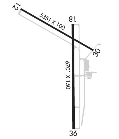
Runway Identifications
Runway Identification: 12/30Length: 5351 ft
Width: 100 ft
Surface: CONCRETE-FAIR CONDITION
Edge lights: Medium IntensityTreatment: GROOVED
Weight: PCN 24 /R/C/X/T
| | Runway: 12 | | Runway: 30 |
| Mag heading: | 119° | Mag heading: | 299° |
| Rwy Slope: | .10% Up | Rwy Slope: | -.10% Down |
| Approach: | | Approach: | |
| Pattern: | Right Traffic | Pattern: | Left Traffic |
| Markings: | NONPRECISION INSTRUMENT | Markings: | NONPRECISION INSTRUMENT |
| Marking Condition: | GOOD | Marking Condition: | GOOD |
| Arresting Dev: | | Arresting Dev: | |
| Lat & Long: | N4047.5 W09108.2 | Lat. & Long.: | N4047.0 W09107.2 |
| Elev: | 692.7 ft. MSL | Elev: | 698.1 ft. MSL |
| TCH: | 39 ft. AGL | TCH: | 30 ft. AGL |
| Visual Glide Path: | 3.00 degrees | Visual Glide Path: | 3.00 degrees |
| Displaced Threshold: | No | Displaced Threshold: | 500 feet |
| Touchdown Zone: | YES | Touchdown Zone: | YES |
| Touchdown Elev.: | 692.7 feet | Touchdown Elev.: | 697.1 feet |
| Visual Glide Slope: | 4-BOX VASI ON LEFT SIDE OF RUNWAY | Visual Glide Slope: | 4-Light PAPI on LEFT side of Runway |
| RVR Equipment: | | RVR Equipment: | |
| RVV Equipment: | NO | RVV Equipment: | NO |
| Approach Lights: | | Approach Lights: | |
| REIL: | YES | REIL: | YES |
| Centerline Lights: | NO | Centerline Lights: | NO |
| Touchdown lights: | NO | Touchdown lights: | NO |
| Runway Category: | Runway with a Non-precision Approach having visibility minimums greater than 3/4 mile | Runway Category: | Runway with a Non-precision Approach having visibility minimums greater than 3/4 mile |
| Declared Distances: | TORA:4850' TODA:5350' ASDA:4850' LDA:5350' | Declared Distances: | TORA:5350' TODA:5350' ASDA:5350' LDA:4850' |
| Obstructions: | | Obstructions: | ROAD |
| Marked: | | Marked: | NOT Marked/Lighted |
| Clearance slope: | 50:1 | Clearance slope: | 25:1 |
| Obstruction height: | | Obstruction height: | 16 feet AGL |
| Dist. from runway: | | Dist. from runway: | 600 feet |
| Centerline offset: | | Centerline offset: | 300 feet right of centerline |
| Comments: | | Comments: | |
Runway Identification: 18/36Length: 6102 ft
Width: 100 ft
Surface: CONCRETE
Edge lights: High IntensityTreatment: GROOVED
Weight: PCN 30 /R/C/X/T
| | Runway: 18 | | Runway: 36 |
| Mag heading: | 179° | Mag heading: | 359° |
| Rwy Slope: | -.29% Down | Rwy Slope: | .29% Up |
| Approach: | | Approach: | ILS |
| Pattern: | Right Traffic | Pattern: | Left Traffic |
| Markings: | NONPRECISION INSTRUMENT | Markings: | PRECISION INSTRUMENT |
| Marking Condition: | GOOD | Marking Condition: | GOOD |
| Arresting Dev: | | Arresting Dev: | |
| Lat & Long: | N4047.2 W09107.4 | Lat. & Long.: | N4046.2 W09107.4 |
| Elev: | 695.4 ft. MSL | Elev: | 677.4 ft. MSL |
| TCH: | 40 ft. AGL | TCH: | |
| Visual Glide Path: | 3.00 degrees | Visual Glide Path: | |
| Displaced Threshold: | No | Displaced Threshold: | No |
| Touchdown Zone: | YES | Touchdown Zone: | YES |
| Touchdown Elev.: | 698.7 feet | Touchdown Elev.: | 695.1 feet |
| Visual Glide Slope: | 4-Light PAPI on LEFT side of Runway | Visual Glide Slope: | |
| RVR Equipment: | | RVR Equipment: | |
| RVV Equipment: | NO | RVV Equipment: | NO |
| Approach Lights: | | Approach Lights: | MALSR - 1,400 foot medium intensity approach lighting system with runway alignment indicator lights |
| REIL: | YES | REIL: | NO |
| Centerline Lights: | NO | Centerline Lights: | NO |
| Touchdown lights: | NO | Touchdown lights: | NO |
| Runway Category: | Runway with a Visual Approach | Runway Category: | Precision Instrument Runway |
| Declared Distances: | TORA:6102' TODA:6102' ASDA:6102' LDA:6102' | Declared Distances: | TORA:6102' TODA:6102' ASDA:6102' LDA:6102' |
| Obstructions: | TREES | Obstructions: | TREE |
| Marked: | NOT Marked/Lighted | Marked: | NOT Marked/Lighted |
| Clearance slope: | 22:1; RWY 18 APCH RATIO 25:1 | Clearance slope: | 45:1 |
| Obstruction height: | 104 feet AGL | Obstruction height: | 40 feet AGL |
| Dist. from runway: | 2588 feet | Dist. from runway: | 2000 feet |
| Centerline offset: | 112 left of centerline | Centerline offset: | 575 feet left of centerline |
| Comments: | | Comments: | |

