Click here for more info on on SMS!

KBQR

BUFFALO-LANCASTER RGNL
LANCASTER
NY
Time Zone: Eastern
Lat: N 4255.3
Long: W 07836.7
Elev: 752
Var: +10
Longest Runway: 3199
CTAF: 123.05

FBO & Flight Services info for KBQR

FBOs: Update your Fuel Prices
Providing high quality fuel and services to you and your customers, from Phillips 66 Aviation.
-
Freq: 123.05Website-
Service
Jet
100LL
SAF
MoGas
Fuel Avail: Please Call for Jet-A
Full        Caution: Fuel prices have not been updated in 34 days.
Last Update: 03/16/2024 14:58

Self  7.45    
Misc. Info: Address: 4343 WALDEN AVE   LANCASTER, NY 14086

If you are an FBO, call 1-203-262-1700 to update your info or email: FltPlan.Advertising@garmin.com
Advertise your FBO on FltPlan.com

Runway & Approach Info for KBQR
Rwy
Length
Land Dist**
Approach*
  Rwy
Length
Land Dist**
Approach*
09
3199x75  3199'          
 
  
27
  3199x75  3199'          
 
 * only ILS, LOC, LDA, and SDF approaches to a specific runway are shown
** For any Declared Landing Distance Available, please see A/FD or Approach plates
Runway Weight Capability (lbs.) Help
Runway IDSingle WheelDouble WheelDouble Tandem WheelDual Double Wheel
09/27N/AN/AN/AN/A
These numbers are Advisory and are not limits.   The Airport Manager should have more accurate Weight Limits
Approach Charts
Approaches    
Current Weather/Notams
Customs Information Send updates to Support@FltPlan.com
Customs Not Available
Database effective 04/18/2024
Airport Diagram of KBQR
Airport Diagram might not be current.

Facility Name: BUFFALO-LANCASTER RGNL
City Name: LANCASTER
County: ERIE
State abbrev: NY
State Name: NEW YORK
   
Ownership: PRIVATELY OWNED
Use: OPEN TO THE PUBLIC
Owner's Name: LANCASTER APT INC (THOMAS GELES)
Address: 4343 WALDEN AVE
 LANCASTER, NY 14086
Owner's Phone: 585-591-0366
  
Manager's Name: GEORGE EZZO
Address:
 DARIEN CENTER, NY 14040-1922
Phone: 716-860-6044
   
FAA Region: EASTERN
FAA Field Office: NYC


Sunrise / Sunset times for BUFFALO-LANCASTER RGNL

DateSunriseSunset
04/18/24 Thursday6:2720:01
04/19/24 Friday6:2520:02
04/20/24 Saturday6:2420:04
04/21/24 Sunday6:2220:05
04/22/24 Monday6:2020:06
04/23/24 Tuesday6:1920:07
04/24/24 Wednesday6:1720:08
04/25/24 Thursday6:1620:09
04/26/24 Friday6:1420:10
04/27/24 Saturday6:1320:12
04/28/24 Sunday6:1220:13
04/29/24 Monday6:1020:14
04/30/24 Tuesday6:0920:15
05/01/24 Wednesday6:0720:16

Airport Facilities

Airport Attendance ScheduleON CALL; 716-860-6044.
Airport Status OPERATIONAL (This Status can change at any time - please check NOTAMS)
Airport Lighting ScheduleACTVT REILS RWY 09 & 27; PAPIS RWY 09 & 27; MIRLS RWY 9/27 - CTAF.
Airport Storage AvailableTie Downs, Hanger
Extra Services AvailableAir Freight, Flight Instruction, Aircraft Rental
Wind IndicatorYES - (lighted)
Control TowerNO
CTAF Frequency123.050
Unicom Frequency123.050; AUTOMATED UNICOM. ADZY ALSO AVBL BY CALLING 617-262-3825.
Rotating Beacon ColorWG
Segmented CircleNO
Landing FeeNO

Airport Inspection Data

Airport InspectedSTATE - performed by STATE AERONAUTICAL PERSONNEL
Inspection Date07/21/2021

Airport Services

Type of Fuel AvailableGrade 100LL
Airframe Repair ServiceMINOR
Power Plant Repair ServiceMAJOR

Geographic Data

LatitudeN4255.3
LongitudeW07836.7 (ESTIMATED)
Arpt Elevation751ft (SURVEYED)
Magnetic Variation10W
3 miles NEof LANCASTER
Traffic Pattern Altitude800
Sectional ChartDETROIT

Aircraft Data

Operations (Reported)YearlyAvg. Daily
General Aviation Transient 1500041
General Aviation Local 3000082
Air Taxi 00
Commerical 00
Commuter 00
Military 00
Aircraft based on Field
General Aviation Singles 74
General Aviation Multi 2
Jet Aircraft 0
General Aviation Helicopters 1
Military Aircraft 0
Gliders 0
Ultralights 0

FAA Services

FSS on field NO
FSS tie-in BUFFALO
FSS Phone 1-800-WX-BRIEF
Who issues Notams BUF
Notam D service at airport YES
ARTCC Name CLEVELAND

Federal Status

Airport Certification
Aircraft Rescue & Firefighting IndexNone
Airport of EntryNo
Custom Landing RightsNo
Joint Civil/MilitaryNo
Military Landing rightsNo

Federal Agreements

NATIONAL PLAN OF INTEGRATED AIRPORT SYSTEMS (NPIAS)

Remarks

+28 FT RAILROAD 215 FT S OF RWY CNTRLN PARALLEL TO RWY 09/27.
FOR CD CTC CLEVELAND ARTCC AT 440-774-0490.
Airport Communications & Frequencies:
CTAF Frequency:
123.050
Unicom Frequency:
123.050; AUTOMATED UNICOM. ADZY ALSO AVBL BY CALLING 617-262-3825.
BUFFALO Primary Approach Frequencies:  
126.15
263.125
BUFFALO Primary Departure Frequencies:  
126.15
263.125
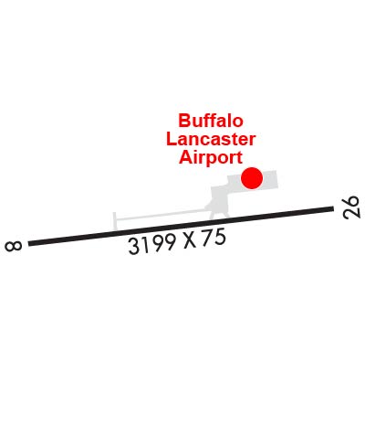
Runway Identifications
Runway Identification: 09/27
Length: 3199 ft
Width: 75 ft
Surface: ASPHALT-GOOD CONDITION
Edge lights: Medium Intensity

Treatment: NONE

 Runway: 09   Runway: 27
Mag heading: N/AMag heading: N/A
Rwy Slope: -.03% DownRwy Slope: .03% Up
Approach: Approach:
Pattern: Left TrafficPattern: Left Traffic
Markings: NONPRECISION INSTRUMENTMarkings: NONPRECISION INSTRUMENT
Marking Condition: GOODMarking Condition: GOOD
Arresting Dev: Arresting Dev:
Lat & Long: N4255.3  W07837.1Lat. & Long.: N4255.4  W07836.4
Elev: 751.6 ft. MSLElev: 750.5 ft. MSL
TCH: 40 ft. AGLTCH: 40 ft. AGL
Visual Glide Path: 3.00 degreesVisual Glide Path: 3.00 degrees
Displaced Threshold: NoDisplaced Threshold: No
Touchdown Zone: YESTouchdown Zone: YES
Touchdown Elev.: 751.7 feetTouchdown Elev.: 751.6 feet
Visual Glide Slope: 2-Light PAPI on RIGHT side of Runway; RWY 09 PAPI UNUSBL BYD 3 DEG RT OF RCL.Visual Glide Slope: 2-Light PAPI on LEFT side of Runway; RWY 27 PAPI UNUSBL BYD 5 DEG LEFT OF RCL.
RVR Equipment: RVR Equipment:
RVV Equipment: NORVV Equipment: NO
Approach Lights: Approach Lights:
REIL: YESREIL: YES
Centerline Lights: NOCenterline Lights: NO
Touchdown lights: NOTouchdown lights: NO
Runway Category: Runway with a Non-precision ApproachRunway Category: Runway with a Non-precision Approach
Declared Distances: Declared Distances:
Obstructions: FENCE; RWY 09; +25-50 FT TREES 150-200 FT S PARALLEL TO RWY 9/27.Obstructions: FENCE; RWY 27; +25-50 FT TREES 150-200 FT S PARALLEL TO RWY 9/27.
Marked: MARKED and LIGHTEDMarked: NOT Marked/Lighted
Clearance slope: Clearance slope:
Obstruction height: 9 feet AGLObstruction height: 8 feet AGL
Dist. from runway: 201 feetDist. from runway: 201 feet
Centerline offset: 157 right of centerlineCenterline offset: 126 feet left of centerline
Comments: +12 FT TREE, 19 FT FM RWY END, 152 FT R.Comments: +8 FT FENCE, 0 FT FROM RWY END, 123 FT LEFT
C:1/P: