
| ||||||||||||||||||||||||||||||||||||||||||||
| ||||||||||||||||||||||||||||||||||||||||||||
| ||||||||||||||||||||||||||||||||||||||||||||
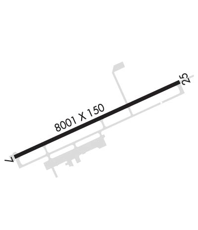
| Rwy | Rwy | |||||||
| 8001x150 | 8001' | 108.50 - 069° | 8001x150 | 8001' | ||||
| Runway ID | Single Wheel | Double Wheel | Double Tandem Wheel | Dual Double Wheel |
| 07/25 | 120,000 | 190,000 | 323,000 | N/A |
| These numbers are Advisory and are not limits. The Airport Manager should have more accurate Weight Limits | ||||
 Airport Diagram might not be current. | |
| Facility Name: | BRUNSWICK GOLDEN ISLES |
| City Name: | BRUNSWICK |
| County: | GLYNN |
| State abbrev: | GA |
| State Name: | GEORGIA |
| Ownership: | PUBLICLY OWNED |
| Use: | OPEN TO THE PUBLIC |
| Owner's Name: | GLYNN COUNTY AIRPORT COMMISSION |
| Address: | 295 AVIATION PARKWAY SUITE 205 |
| BRUNSWICK, GA 31525 | |
| Owner's Phone: | (912) 265-2070 |
| Manager's Name: | ROBERT J. BURR |
| Address: | 295 AVIATION PKWY. SUITE 205 |
| BRUNSWICK, GA 31525 | |
| Phone: | 912-265-2070 |
| FAA Region: | SOUTHERN |
| FAA Field Office: | ATL |

| Date | Sunrise | Sunset |
|---|---|---|
| 05/06/24 Monday | 6:36 | 20:09 |
| 05/07/24 Tuesday | 6:35 | 20:10 |
| 05/08/24 Wednesday | 6:34 | 20:11 |
| 05/09/24 Thursday | 6:34 | 20:11 |
| 05/10/24 Friday | 6:33 | 20:12 |
| 05/11/24 Saturday | 6:32 | 20:13 |
| 05/12/24 Sunday | 6:32 | 20:13 |
| 05/13/24 Monday | 6:31 | 20:14 |
| 05/14/24 Tuesday | 6:30 | 20:15 |
| 05/15/24 Wednesday | 6:30 | 20:15 |
| 05/16/24 Thursday | 6:29 | 20:16 |
| 05/17/24 Friday | 6:28 | 20:17 |
| 05/18/24 Saturday | 6:28 | 20:17 |
| 05/19/24 Sunday | 6:27 | 20:18 |
| Airport Attendance Schedule | 7 Days A Week 0700-2000; PPR FOR SVC & FUEL AFT HRS CALL (912) 264-9200. |
| Airport Status | OPERATIONAL (This Status can change at any time - please check NOTAMS) |
| Airport Lighting Schedule | ACTVT MALSR RWY 07; REIL RWY 25; PAPI RWY 07 & 25; HIRL RWY 07/25 - CTAF. |
| Airport Storage Available | Tie Downs, Hanger |
| Extra Services Available | Cargo Handling, Charter, Flight Instruction, Aircraft Rental |
| Wind Indicator | YES - (lighted) |
| Control Tower | NO |
| CTAF Frequency | 123.000 |
| Unicom Frequency | 123.000 |
| Rotating Beacon Color | WG |
| Segmented Circle | YES |
| Landing Fee | NO |
| Airport Inspected | FEDERAL - performed by FAA AIRPORTS FIELD PERSONNEL |
| Inspection Date | 04/04/2023 |
| Type of Fuel Available | Grade 100LL, JET A (freeze point -40C) |
| Airframe Repair Service | MAJOR |
| Power Plant Repair Service | MAJOR |
| Latitude | N3115.5 |
| Longitude | W08128.0 (ESTIMATED) |
| Arpt Elevation | 25ft (SURVEYED) |
| Magnetic Variation | 04W |
| 5 miles N | of BRUNSWICK |
| Traffic Pattern Altitude | |
| Sectional Chart | JACKSONVILLE |
| Operations (Reported) | Yearly | Avg. Daily |
|---|---|---|
| General Aviation Transient | 9857 | 27 |
| General Aviation Local | 8262 | 23 |
| Air Taxi | 1200 | 3 |
| Commerical | 1095 | 3 |
| Commuter | 0 | 0 |
| Military | 500 | 1 |
| Aircraft based on Field | |
|---|---|
| General Aviation Singles | 26 |
| General Aviation Multi | 2 |
| Jet Aircraft | 0 |
| General Aviation Helicopters | 0 |
| Military Aircraft | 0 |
| Gliders | 0 |
| Ultralights | 0 |
| FSS on field | NO |
| FSS tie-in | MACON |
| FSS Phone | 1-800-WX-BRIEF |
| Who issues Notams | BQK |
| Notam D service at airport | YES |
| ARTCC Name | JACKSONVILLE |
| Airport Certification | AIRPORT RECEIVING SCHEDULED AIR CARRIER SERVICE FROM CARRIERS CERTIFICATED BY THE CIVIL AERONAUTICS BOARD; PPR 24 HRS FOR CHARTER ACFT OPS WITH MORE THAN 30 PASSENGER SEATS CALL AMGR 912-265-2070. |
| Aircraft Rescue & Firefighting Index | AIRPORT HAS A CERTIFICATE UNDER CFR PART 139 |
| Airport of Entry | No |
| Custom Landing Rights | YES |
| Joint Civil/Military | No |
| Military Landing rights | YES |
| NATIONAL PLAN OF INTEGRATED AIRPORT SYSTEMS (NPIAS) |
| GRANT AGREEMENTS UNDER FAAP/ADAP/AIP |
| SURPLUS PROPERTY AGREEMENT UNDER PUBLIC LAW 289 |
| ASSURANCES PURSUANT TO TITLE VI, CIVIL RIGHTS ACT OF 1964 |
| BIRDS ON & IN VCNTY OF ARPT DURG HVY RAINS & HIGH NORTHEASTERLY WINDS. |
| DEER ON & INVOF ARPT. |
| USE CTN DUE TO CONGESTED ASP WITH TURBINE, NON-TURBINE AND TRAINING ACFT. KSSI LOCATED 7NM SE. |
| ALL VFR ACFT ADHERE TO STD LH TFC PAT. |
| ALL ARRIVALS AND DEP, INCLUDING ACFT FLYING INST APPROACHES, ARE REQSTD TO RPRT 10 MILES FROM THE AP, INTNS AND PSN REPORTS TO "BRUNSWICK" CTAF 123.00. |
| ADDITIONAL APT SAFETY BULLETINS POSTED AT WWW.FLYGCAIRPORTS.COM/SAFETY. |
| FOR CD CTC JACKSONVILLE ARTCC AT 904-845-1592. |
| RWY 07/2 5 25 FT FULL STRENGTH SHOULDERS EACH SIDE. |
Airport Communications & Frequencies:
| |||||||||
| Runway: 07 | Runway: 25 | ||
| Mag heading: | 69° | Mag heading: | 249° |
| Rwy Slope: | .01% Up | Rwy Slope: | -.01% Down |
| Approach: | ILS | Approach: | |
| Pattern: | Left Traffic | Pattern: | Left Traffic |
| Markings: | PRECISION INSTRUMENT | Markings: | PRECISION INSTRUMENT |
| Marking Condition: | FAIR | Marking Condition: | FAIR |
| Arresting Dev: | Arresting Dev: | ||
| Lat & Long: | N3115.3 W08128.7 | Lat. & Long.: | N3115.8 W08127.3 |
| Elev: | 19.8 ft. MSL | Elev: | 20.3 ft. MSL |
| TCH: | 58 ft. AGL | TCH: | 50 ft. AGL |
| Visual Glide Path: | 3.00 degrees | Visual Glide Path: | 3.00 degrees |
| Displaced Threshold: | No | Displaced Threshold: | No |
| Touchdown Zone: | YES | Touchdown Zone: | YES |
| Touchdown Elev.: | 25.6 feet | Touchdown Elev.: | 25.5 feet |
| Visual Glide Slope: | 4-Light PAPI on LEFT side of Runway | Visual Glide Slope: | 4-Light PAPI on LEFT side of Runway |
| RVR Equipment: | RVR Equipment: | ||
| RVV Equipment: | NO | RVV Equipment: | NO |
| Approach Lights: | MALSR - 1,400 foot medium intensity approach lighting system with runway alignment indicator lights | Approach Lights: | |
| REIL: | NO | REIL: | YES |
| Centerline Lights: | NO | Centerline Lights: | NO |
| Touchdown lights: | NO | Touchdown lights: | NO |
| Runway Category: | Precision Instrument Runway | Runway Category: | D |
| Declared Distances: | Declared Distances: |