Click here for more info on on SMS!

KBPT

JACK BROOKS REGIONAL AIRPORT
BEAUMONT/PORT ARTHUR
TX
Time Zone: Central
Lat: N 2957.0
Long: W 09401.2
Elev: 15
Var: -01
Longest Runway: 6751
Clr Del: 118.3
Dept. ATIS: 126.3
Arr. ATIS: 126.3
Ground: 124.85
Tower: 119.5

FBO & Flight Services info for KBPT

FBOs: Update your Fuel Prices
KUSA Aviation has moved to hangar 5 on the east ramp off of foxtrot. Our offerings to visiting pilots include a Private Corporate Pilot Lounge, Flight Planning Area, Line Services, Rental Cars and Hotel Booking, as well as our Store where pilots can find all the items needed for the flight. We also offer Hangar Storage, Aircraft Management, Aircraft Rentals, and Maintenance.
Ph: 409-727-7900 Fax: 409-727-7901 Freq: 123.3WebsiteE-Mail
                     
Service
Jet
100LL
SAF
MoGas
Fuel Avail: PRIST+$0.05/gal
Full6.506.33    Last Update: 03/16/2024 12:33

Self        
Misc. Info: 24-hour Call Out AvailabilityAddress: 4700 HANGAR DR,   BEAUMONT, TX 77705

JACK BROOKS APPh: 409-719-4950 Fax: 409-727-3798 Freq: 122.95
Service
Jet
100LL
SAF
MoGas
Fuel Avail: Jet A w/prist + $0.05, 24/7 Hours a day. 7 Days a week.
Full5.905.70    Last Update: 03/16/2024 12:32  
Self        
 Address: 5000 JERRY WARE DR UNIT 100,   BEAUMONT TX 7705
ASOSPh: 409-722-3408
-
-
 
If you are an FBO, call 1-203-262-1700 to update your info or email: FltPlan.Advertising@garmin.com
Advertise your FBO on FltPlan.com

Runway & Approach Info for KBPT
Rwy
Length
Land Dist**
Approach*
  Rwy
Length
Land Dist**
Approach*
12
6751x150  6751'          
ILS/DME
 110.15 - 115°  
  
30
  6751x150  6751'          
 
16
5071x150  5071'          
 
  
34
  5071x150  5071'          
 
 * only ILS, LOC, LDA, and SDF approaches to a specific runway are shown
** For any Declared Landing Distance Available, please see A/FD or Approach plates
Runway Weight Capability (lbs.) Help
Runway IDSingle WheelDouble WheelDouble Tandem WheelDual Double Wheel
12/3090,000170,000230,000N/A
16/3470,00090,000145,000N/A
These numbers are Advisory and are not limits.   The Airport Manager should have more accurate Weight Limits
Approach Charts
Approaches    
Current Weather/Notams
Customs Information Send updates to Support@FltPlan.com
Phone 409-727-2895
Fax 409-724-6360

Comments 2 hr advance notice required. Business hrs 0830-1700 Monday-Friday. *Maximum passengers per flight: 20 *Call prior to 1700 on preceding weekday. *Weekend arrivals call prior to 1700 on preceeding Friday
Database effective 03/21/2024
Airport Diagram of KBPT
Airport Diagram might not be current.

Facility Name: JACK BROOKS RGNL
City Name: BEAUMONT/PORT ARTHUR
County: JEFFERSON
State abbrev: TX
State Name: TEXAS
   
Ownership: PUBLICLY OWNED
Use: OPEN TO THE PUBLIC
Owner's Name: JEFFERSON COUNTY
Address: 1149 PEARL ST 4TH FLOOR
 BEAUMONT, TX 77701
Owner's Phone: 409-835-8466
  
Manager's Name: ALEX RUPP
Address: 5000 JERRY WARE DR SUITE 100
 BEAUMONT, TX 77705
Phone: 409-719-4900
   
FAA Region: SOUTHWEST
FAA Field Office: TEX
Photo courtesy of Martin Von Almen, October 2016.


Click here for full scale & interactive Sectional view of KBPT


Sunrise / Sunset times for JACK BROOKS RGNL

DateSunriseSunset
03/18/24 Monday7:2119:27
03/19/24 Tuesday7:2019:27
03/20/24 Wednesday7:1919:28
03/21/24 Thursday7:1819:29
03/22/24 Friday7:1719:29
03/23/24 Saturday7:1519:30
03/24/24 Sunday7:1419:31
03/25/24 Monday7:1319:31
03/26/24 Tuesday7:1219:32
03/27/24 Wednesday7:1119:32
03/28/24 Thursday7:0919:33
03/29/24 Friday7:0819:34
03/30/24 Saturday7:0719:34
03/31/24 Sunday7:0619:35

Airport Facilities

Airport Attendance ScheduleCONTINUOUS
Airport Status OPERATIONAL (This Status can change at any time - please check NOTAMS)
Airport Lighting ScheduleDUSK-DAWN. WHEN ATCT CLSD REIL RWYS 16, 30 & 34; HIRL RWY 12/30 & 16/34 PRESET MED INTST. ACTVT MALSR RWY 12 - CTAF.
Airport Storage AvailableTie Downs, Hanger
Extra Services AvailableAir Freight, Charter, Flight Instruction, Aircraft Rental
Wind IndicatorYES - (lighted)
Control TowerYES
CTAF Frequency119.500
Unicom Frequency122.950
Rotating Beacon ColorWG
Segmented CircleYES
Landing FeeNO

Airport Inspection Data

Airport InspectedFEDERAL - performed by FAA AIRPORTS FIELD PERSONNEL
Inspection Date01/19/2023

Airport Services

Type of Fuel AvailableGrade 100LL, JET A (freeze point -40C)
Airframe Repair ServiceMINOR
Power Plant Repair ServiceMINOR

Geographic Data

LatitudeN2957.0
LongitudeW09401.2 (ESTIMATED)
Arpt Elevation14ft (SURVEYED)
Magnetic Variation01E
9 miles SEof BEAUMONT/PORT ARTHUR
Traffic Pattern Altitude
Sectional ChartHOUSTON

Aircraft Data

Operations (Reported)YearlyAvg. Daily
General Aviation Transient 964726
General Aviation Local 631317
Air Taxi 16705
Commerical 3201
Commuter 00
Military 9443
Aircraft based on Field
General Aviation Singles 41
General Aviation Multi 6
Jet Aircraft 14
General Aviation Helicopters 4
Military Aircraft 0
Gliders 0
Ultralights 0

FAA Services

FSS on field NO
FSS tie-in MONTGOMERY COUNTY
FSS Phone 1-800-WX-BRIEF
Who issues Notams BPT
Notam D service at airport YES
ARTCC Name HOUSTON

Federal Status

Airport CertificationAIRPORT RECEIVING SCHEDULED AIR CARRIER SERVICE FROM CARRIERS CERTIFICATED BY THE CIVIL AERONAUTICS BOARD
Aircraft Rescue & Firefighting IndexAIRPORT HAS A CERTIFICATE UNDER CFR PART 139
Airport of EntryNo
Custom Landing RightsYES
Joint Civil/MilitaryNo
Military Landing rightsYES

Federal Agreements

NATIONAL PLAN OF INTEGRATED AIRPORT SYSTEMS (NPIAS)
GRANT AGREEMENTS UNDER FAAP/ADAP/AIP
SURPLUS PROPERTY AGREEMENT UNDER PUBLIC LAW 289
ASSURANCES PURSUANT TO TITLE VI, CIVIL RIGHTS ACT OF 1964
AGREEMENT UNDER DLAND OR DCLA HAS EXPIRED.

Remarks

BIRD ACTVTY ON & INVOF ARPT.
FOR CD WHEN ATCT IS CLSD CTC HOUSTON APCH AT 281-443-5844 TO CNL IFR AT 281-443-5888.
RWY 16/3 4 FIRST 1000 FT RWY 16 MUCH DARKER THAN REMAINDER OF RWY.
RWY 16/3 4 FIRST 4271 FT OF RWY 34 GRVD.
RWY 16/3 4 FIRST 1000 FT OF RWY 16 PCN REPORTED AS 28/F/D/X/U.
Airport Communications & Frequencies:
ATIS Frequencies:   Hours(local) of Operation: CONTINUOUS
126.3
BEAUMONT Tower Frequencies:   Hours(local) of operation: 0600-2200   
119.5
BEAUMONT Ground Frequencies:
124.85
Clearance Delivery Frequencies:
118.3
Emergency Frequencies:
121.5
243.0
CTAF Frequency:
119.500
Unicom Frequency:
122.950
HOUSTON Primary Approach Frequencies:  
121.3
377.1
HOUSTON Primary Departure Frequencies:  
121.3
377.1
Runway Identifications
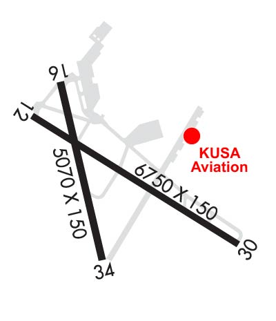
Runway Identification: 12/30
Length: 6751 ft
Width: 150 ft
Surface: CONCRETE-GOOD CONDITION
Edge lights: High Intensity

Treatment: GROOVED
Weight: PCN 37 /R/D/X/U

 Runway: 12   Runway: 30
Mag heading: 120°Mag heading: 300°
Rwy Slope: -.13% DownRwy Slope: .13% Up
Approach: ILS/DMEApproach:
Pattern: Left TrafficPattern: Left Traffic
Markings: PRECISION INSTRUMENTMarkings: PRECISION INSTRUMENT
Marking Condition: GOODMarking Condition: GOOD
Arresting Dev: Arresting Dev:
Lat & Long: N2957.3  W09401.7Lat. & Long.: N2956.7  W09400.6
Elev: 14.4 ft. MSLElev: 5.8 ft. MSL
TCH: TCH: 54 ft. AGL
Visual Glide Path: Visual Glide Path: 3.00 degrees
Displaced Threshold: NoDisplaced Threshold: No
Touchdown Zone: YESTouchdown Zone: YES
Touchdown Elev.: 14.8 feetTouchdown Elev.: 11.7 feet
Visual Glide Slope: Visual Glide Slope: 4-BOX VASI ON LEFT SIDE OF RUNWAY
RVR Equipment: TOUCHDOWNRVR Equipment: ROLLOUT
RVV Equipment: NORVV Equipment: NO
Approach Lights: MALSR - 1,400 foot medium intensity approach lighting system with runway alignment indicator lightsApproach Lights:
REIL: NOREIL: YES
Centerline Lights: NOCenterline Lights: NO
Touchdown lights: NOTouchdown lights: NO
Runway Category: Precision Instrument RunwayRunway Category: Runway with a Non-precision Approach having visibility minimums greater than 3/4 mile
Declared Distances: TORA:6751' TODA:6751' ASDA:6508' LDA:6508'Declared Distances: TORA:6751' TODA:6751' ASDA:6751' LDA:6751'
Obstructions: TREEObstructions: TREE
Marked: NOT Marked/LightedMarked: NOT Marked/Lighted
Clearance slope: 18:1Clearance slope: 20:1
Obstruction height: 46 feet AGLObstruction height: 41 feet AGL
Dist. from runway: 1041 feetDist. from runway: 1024 feet
Centerline offset: 618 right of centerlineCenterline offset: 529 feet right of centerline
Comments: Comments:
Runway Identification: 16/34
Length: 5071 ft
Width: 150 ft
Surface: CONCRETE ASPHALT-FAIR CONDITION
Edge lights: High Intensity

Treatment: GROOVED
Weight: PCN 26 /R/D/X/U

 Runway: 16   Runway: 34
Mag heading: 165°Mag heading: 345°
Rwy Slope: -.07% DownRwy Slope: .07% Up
Approach: Approach:
Pattern: Left TrafficPattern: Left Traffic
Markings: NONPRECISION INSTRUMENTMarkings: NONPRECISION INSTRUMENT
Marking Condition: GOODMarking Condition: GOOD
Arresting Dev: Arresting Dev:
Lat & Long: N2957.5  W09401.5Lat. & Long.: N2956.7  W09401.3
Elev: 14.4 ft. MSLElev: 10.9 ft. MSL
TCH: 53 ft. AGLTCH: 53 ft. AGL
Visual Glide Path: 3.00 degreesVisual Glide Path: 3.00 degrees
Displaced Threshold: NoDisplaced Threshold: No
Touchdown Zone: YESTouchdown Zone: YES
Touchdown Elev.: 14.7 feetTouchdown Elev.: 14.4 feet
Visual Glide Slope: 4-Light PAPI on RIGHT side of RunwayVisual Glide Slope: 4-BOX VASI ON LEFT SIDE OF RUNWAY
RVR Equipment: RVR Equipment:
RVV Equipment: NORVV Equipment: NO
Approach Lights: Approach Lights:
REIL: YESREIL: YES
Centerline Lights: NOCenterline Lights: NO
Touchdown lights: NOTouchdown lights: NO
Runway Category: Runway with a Non-precision Approach having visibility minimums greater than 3/4 mileRunway Category: Runway with a Non-precision Approach having visibility minimums greater than 3/4 mile
Declared Distances: TORA:5070' TODA:5070' ASDA:5070' LDA:5070'Declared Distances: TORA:5070' TODA:5070' ASDA:5070' LDA:5070'
C:52/P: