Current Weather/Notams (Metars, TAFs, Notams, NWS Forecast, PIREPS, and nearby weather)
Customs Information Send updates to Support@FltPlan.com
Customs Not Available
Database effective 05/16/2024
Airport Diagram might not be current.
|
| Facility Name: | BAXTER COUNTY |
| City Name: | MOUNTAIN HOME |
| County: | BAXTER |
| State abbrev: | AR |
| State Name: | ARKANSAS |
| | |
| Ownership: | PUBLICLY OWNED |
| Use: | OPEN TO THE PUBLIC |
| Owner's Name: | BAXTER COUNTY |
| Address: | CTY COURTHOUSE 1 E 7TH ST STE 303 |
| | MOUNTAIN HOME, AR 72653 |
| Owner's Phone: | 870-425-2755 |
| | |
| Manager's Name: | TAYLOR CARMICHAEL |
| Address: | 6462 HWY 126 NORTH |
| | MIDWAY, AR 72651 |
| Phone: | 870-481-5418 |
| | |
| FAA Region: | SOUTHWEST |
| FAA Field Office: | AOK |
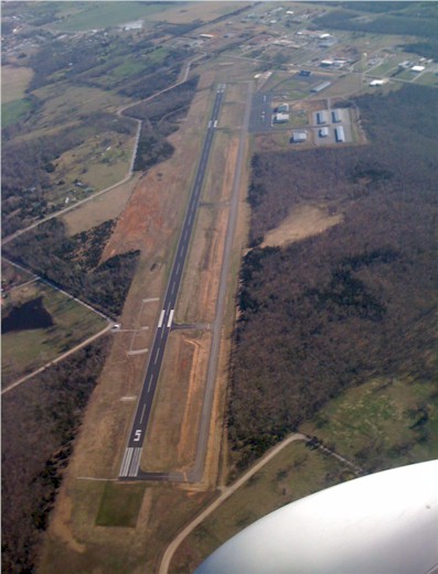
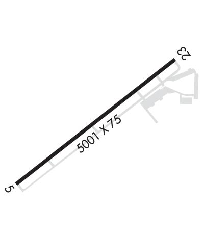
Runway Identifications
Runway Identification: 05/23Length: 5000 ft
Width: 75 ft
Surface: ASPHALT-GOOD CONDITION
Edge lights: Medium IntensityTreatment: NONE
| | Runway: 05 | | Runway: 23 |
| Mag heading: | 49° | Mag heading: | 229° |
| Rwy Slope: | -.33% Down | Rwy Slope: | .33% Up |
| Approach: | ILS/DME | Approach: | |
| Pattern: | Left Traffic | Pattern: | Left Traffic |
| Markings: | NONPRECISION INSTRUMENT | Markings: | NONPRECISION INSTRUMENT |
| Marking Condition: | GOOD | Marking Condition: | GOOD |
| Arresting Dev: | | Arresting Dev: | |
| Lat & Long: | N3621.9 W09228.6 | Lat. & Long.: | N3622.4 W09227.8 |
| Elev: | 928.0 ft. MSL | Elev: | 911.7 ft. MSL |
| TCH: | 38 ft. AGL | TCH: | 46 ft. AGL |
| Visual Glide Path: | 3.00 degrees | Visual Glide Path: | 4.00 degrees |
| Displaced Threshold: | No | Displaced Threshold: | No |
| Touchdown Zone: | YES | Touchdown Zone: | YES |
| Touchdown Elev.: | 928.0 feet | Touchdown Elev.: | 918.9 feet |
| Visual Glide Slope: | 4-Light PAPI on RIGHT side of Runway | Visual Glide Slope: | 2-Light PAPI on LEFT side of Runway |
| RVR Equipment: | | RVR Equipment: | |
| RVV Equipment: | NO | RVV Equipment: | NO |
| Approach Lights: | | Approach Lights: | |
| REIL: | YES | REIL: | YES |
| Centerline Lights: | NO | Centerline Lights: | NO |
| Touchdown lights: | NO | Touchdown lights: | NO |
| Runway Category: | Precision Instrument Runway | Runway Category: | Runway with a Non-precision Approach having visibility minimums greater than 3/4 mile |
| Declared Distances: | | Declared Distances: | |
| Obstructions: | ROAD | Obstructions: | PLINE |
| Marked: | NOT Marked/Lighted | Marked: | NOT Marked/Lighted |
| Clearance slope: | 26:1 | Clearance slope: | 20:1 |
| Obstruction height: | 19 feet AGL | Obstruction height: | 55 feet AGL |
| Dist. from runway: | 701 feet | Dist. from runway: | 1300 feet |
| Centerline offset: | | Centerline offset: | 300 feet right of centerline |
| Comments: | GND GRADUALLY RISES AWAY FM RY APRXLY 3' WITHIN CLOSE-IN AREA. | Comments: | |