Current Weather/Notams (Metars, TAFs, Notams, NWS Forecast, PIREPS, and nearby weather)
Customs Information Send updates to Support@FltPlan.com
Customs Not Available
Database effective 04/18/2024
Airport Diagram might not be current.
|
| Facility Name: | MILEY MEML FLD |
| City Name: | BIG PINEY |
| County: | SUBLETTE |
| State abbrev: | WY |
| State Name: | WYOMING |
| | |
| Ownership: | PUBLICLY OWNED |
| Use: | OPEN TO THE PUBLIC |
| Owner's Name: | BIG PINEY-MARBLETON AIRPORT BOARD |
| Address: | P.O. BOX 307 |
| | BIG PINEY, WY 83113 |
| Owner's Phone: | (307) 276-4022; ARPT BOARD CLERK - SHELLY BRAUSE (307) 749-2725. |
| | |
| Manager's Name: | PHIL STEVENS |
| Address: | P.O. BOX 307 |
| | BIG PINEY, WY 83113 |
| Phone: | 307-231-6244 |
| | |
| FAA Region: | NORTHWEST MOUNTAIN |
| FAA Field Office: | DEN |
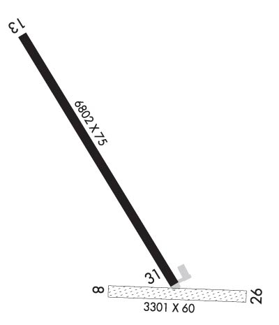
Runway Identifications
Runway Identification: 08/26Length: 3301 ft
Width: 60 ft
Surface: GRASS NATURAL SOIL-GOOD CONDITION
Edge lights: Treatment: NONE
| | Runway: 08 | | Runway: 26 |
| Mag heading: | 83° | Mag heading: | 263° |
| Rwy Slope: | -.23% Down | Rwy Slope: | .23% Up |
| Approach: | | Approach: | |
| Pattern: | Left Traffic | Pattern: | Left Traffic |
| Markings: | NONE | Markings: | NONE |
| Marking Condition: | FAIR | Marking Condition: | FAIR |
| Arresting Dev: | | Arresting Dev: | |
| Lat & Long: | N4234.6 W11006.6 | Lat. & Long.: | N4234.6 W11005.9 |
| Elev: | 6943.4 ft. MSL | Elev: | 6935.8 ft. MSL |
| TCH: | | TCH: | |
| Visual Glide Path: | | Visual Glide Path: | |
| Displaced Threshold: | No | Displaced Threshold: | No |
| Touchdown Zone: | YES | Touchdown Zone: | YES |
| Touchdown Elev.: | 6944.9 feet | Touchdown Elev.: | 6944.6 feet |
| Visual Glide Slope: | | Visual Glide Slope: | |
| RVR Equipment: | | RVR Equipment: | |
| RVV Equipment: | NO | RVV Equipment: | NO |
| Approach Lights: | | Approach Lights: | |
| REIL: | NO | REIL: | NO |
| Centerline Lights: | NO | Centerline Lights: | NO |
| Touchdown lights: | NO | Touchdown lights: | NO |
| Runway Category: | Runway with a Visual Approach | Runway Category: | Runway with a Visual Approach |
| Declared Distances: | | Declared Distances: | |
| Obstructions: | POLE | Obstructions: | |
| Marked: | NOT Marked/Lighted | Marked: | |
| Clearance slope: | 46:1 | Clearance slope: | 50:1 |
| Obstruction height: | 17 feet AGL | Obstruction height: | |
| Dist. from runway: | 798 feet | Dist. from runway: | |
| Centerline offset: | 21 right of centerline | Centerline offset: | |
| Comments: | | Comments: | |
Runway Identification: 13/31Length: 6803 ft
Width: 75 ft
Surface: ASPHALT-GOOD CONDITION
Edge lights: Medium IntensityTreatment: NONE
Weight: PCN 31 /F/A/X/T
| | Runway: 13 | | Runway: 31 |
| Mag heading: | 138° | Mag heading: | 318° |
| Rwy Slope: | -.66% Down | Rwy Slope: | .66% Up |
| Approach: | | Approach: | |
| Pattern: | Left Traffic | Pattern: | Left Traffic |
| Markings: | NONPRECISION INSTRUMENT | Markings: | NONPRECISION INSTRUMENT |
| Marking Condition: | GOOD | Marking Condition: | GOOD |
| Arresting Dev: | | Arresting Dev: | |
| Lat & Long: | N4235.6 W11007.1 | Lat. & Long.: | N4234.6 W11006.3 |
| Elev: | 6993.6 ft. MSL | Elev: | 6948.8 ft. MSL |
| TCH: | 34 ft. AGL | TCH: | 33 ft. AGL |
| Visual Glide Path: | 3.00 degrees | Visual Glide Path: | 3.00 degrees |
| Displaced Threshold: | No | Displaced Threshold: | No |
| Touchdown Zone: | YES | Touchdown Zone: | YES |
| Touchdown Elev.: | 6993.6 feet | Touchdown Elev.: | 6969.1 feet |
| Visual Glide Slope: | 2-Light PAPI on LEFT side of Runway | Visual Glide Slope: | 2-Light PAPI on LEFT side of Runway |
| RVR Equipment: | | RVR Equipment: | |
| RVV Equipment: | NO | RVV Equipment: | NO |
| Approach Lights: | | Approach Lights: | |
| REIL: | YES | REIL: | YES |
| Centerline Lights: | NO | Centerline Lights: | NO |
| Touchdown lights: | NO | Touchdown lights: | NO |
| Runway Category: | Runway with a Visual Approach | Runway Category: | Runway with a Non-precision Approach having visibility minimums greater than 3/4 mile |
| Declared Distances: | | Declared Distances: | |

