Current Weather/Notams (Metars, TAFs, Notams, NWS Forecast, PIREPS, and nearby weather)
Customs Information Send updates to Support@FltPlan.com
Customs Not Available
Database effective 05/16/2024
Airport Diagram might not be current.
|
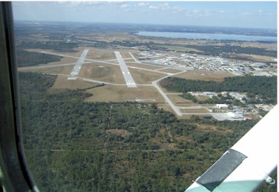
| Facility Name: | BARTOW EXEC |
| City Name: | BARTOW |
| County: | POLK |
| State abbrev: | FL |
| State Name: | FLORIDA |
| | |
| Ownership: | PUBLICLY OWNED |
| Use: | OPEN TO THE PUBLIC |
| Owner's Name: | BARTOW MUNI ARPT DVLPMNT AUTH |
| Address: | PO BOX 650 |
| | BARTOW, FL 33831-0650 |
| Owner's Phone: | 863-533-1195 |
| | |
| Manager's Name: | JOHN B. HELMS, II |
| Address: | 5993 AIRPORT BLVD |
| | BARTOW, FL 33830 |
| Phone: | 863-533-1195 |
| | |
| FAA Region: | SOUTHERN |
| FAA Field Office: | ORL |
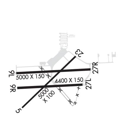
Runway Identifications
Runway Identification: 05/23Length: 5001 ft
Width: 100 ft
Surface: ASPHALT-POOR CONDITION
Edge lights: Medium IntensityTreatment: NONE
Weight: PCN 27 /F/A/X/T
| | Runway: 05 | | Runway: 23 |
| Mag heading: | 50° | Mag heading: | 230° |
| Rwy Slope: | .29% Up | Rwy Slope: | -.29% Down |
| Approach: | | Approach: | |
| Pattern: | Left Traffic | Pattern: | Left Traffic |
| Markings: | NONPRECISION INSTRUMENT | Markings: | NONPRECISION INSTRUMENT |
| Marking Condition: | GOOD | Marking Condition: | GOOD |
| Arresting Dev: | | Arresting Dev: | |
| Lat & Long: | N2756.3 W08147.4 | Lat. & Long.: | N2756.9 W08146.7 |
| Elev: | 107.9 ft. MSL | Elev: | 122.2 ft. MSL |
| TCH: | 51 ft. AGL | TCH: | 48 ft. AGL |
| Visual Glide Path: | 3.50 degrees | Visual Glide Path: | 3.50 degrees |
| Displaced Threshold: | No | Displaced Threshold: | No |
| Touchdown Zone: | YES | Touchdown Zone: | YES |
| Touchdown Elev.: | 123.4 feet | Touchdown Elev.: | 124.0 feet |
| Visual Glide Slope: | 4-Light PAPI on LEFT side of Runway | Visual Glide Slope: | 4-Light PAPI on LEFT side of Runway |
| RVR Equipment: | | RVR Equipment: | |
| RVV Equipment: | NO | RVV Equipment: | NO |
| Approach Lights: | | Approach Lights: | |
| REIL: | YES | REIL: | YES |
| Centerline Lights: | NO | Centerline Lights: | NO |
| Touchdown lights: | NO | Touchdown lights: | NO |
| Runway Category: | Runway with a Non-precision Approach having visibility minimums greater than 3/4 mile | Runway Category: | Runway with a Non-precision Approach having visibility minimums greater than 3/4 mile |
| Declared Distances: | | Declared Distances: | |
| Obstructions: | TREES | Obstructions: | TREES |
| Marked: | NOT Marked/Lighted | Marked: | NOT Marked/Lighted |
| Clearance slope: | 36:1 | Clearance slope: | 32:1 |
| Obstruction height: | 33 feet AGL | Obstruction height: | 45 feet AGL |
| Dist. from runway: | 1380 feet | Dist. from runway: | 1620 feet |
| Centerline offset: | 250 left of centerline | Centerline offset: | 250 feet left of centerline |
| Comments: | | Comments: | |
Runway Identification: 09L/27RLength: 5000 ft
Width: 150 ft
Surface: ASPHALT-GOOD CONDITION
Edge lights: Medium IntensityTreatment: NONE
Weight: PCN 48 /F/A/W/T
| | Runway: 09L | | Runway: 27R |
| Mag heading: | 91° | Mag heading: | 271° |
| Rwy Slope: | -.05% Down | Rwy Slope: | .05% Up |
| Approach: | | Approach: | |
| Pattern: | Left Traffic | Pattern: | Left Traffic |
| Markings: | NONPRECISION INSTRUMENT | Markings: | NONPRECISION INSTRUMENT |
| Marking Condition: | GOOD | Marking Condition: | GOOD |
| Arresting Dev: | | Arresting Dev: | |
| Lat & Long: | N2756.7 W08147.4 | Lat. & Long.: | N2756.7 W08146.5 |
| Elev: | 116.9 ft. MSL | Elev: | 114.5 ft. MSL |
| TCH: | 46 ft. AGL | TCH: | 34 ft. AGL |
| Visual Glide Path: | 3.00 degrees | Visual Glide Path: | 3.00 degrees |
| Displaced Threshold: | No | Displaced Threshold: | No |
| Touchdown Zone: | YES | Touchdown Zone: | YES |
| Touchdown Elev.: | 124.6 feet | Touchdown Elev.: | 124.6 feet |
| Visual Glide Slope: | 4-Light PAPI on LEFT side of Runway | Visual Glide Slope: | 4-Light PAPI on LEFT side of Runway |
| RVR Equipment: | | RVR Equipment: | |
| RVV Equipment: | NO | RVV Equipment: | NO |
| Approach Lights: | | Approach Lights: | |
| REIL: | YES | REIL: | YES |
| Centerline Lights: | NO | Centerline Lights: | NO |
| Touchdown lights: | NO | Touchdown lights: | NO |
| Runway Category: | Runway with a Non-precision Approach having visibility minimums greater than 3/4 mile | Runway Category: | Runway with a Non-precision Approach having visibility minimums greater than 3/4 mile |
| Declared Distances: | | Declared Distances: | |
| Obstructions: | TREE | Obstructions: | TREE |
| Marked: | NOT Marked/Lighted | Marked: | NOT Marked/Lighted |
| Clearance slope: | 34:1 | Clearance slope: | 34:1 |
| Obstruction height: | 62 feet AGL | Obstruction height: | 28 feet AGL |
| Dist. from runway: | 2290 feet | Dist. from runway: | 1130 feet |
| Centerline offset: | 110 right of centerline | Centerline offset: | 240 feet left of centerline |
| Comments: | | Comments: | |
Runway Identification: 09R/27LLength: 4416 ft
Width: 150 ft
Surface: CONCRETE ASPHALT-POOR CONDITION
Edge lights: Treatment: NONE
Weight: PCN 6 /F/A/Y/T
| | Runway: 09R | | Runway: 27L |
| Mag heading: | 91° | Mag heading: | 271° |
| Rwy Slope: | -.02% Down | Rwy Slope: | .02% Up |
| Approach: | | Approach: | |
| Pattern: | Left Traffic | Pattern: | Left Traffic |
| Markings: | BASIC | Markings: | BASIC |
| Marking Condition: | GOOD | Marking Condition: | GOOD |
| Arresting Dev: | | Arresting Dev: | |
| Lat & Long: | N2756.5 W08147.4 | Lat. & Long.: | N2756.5 W08146.6 |
| Elev: | 112.3 ft. MSL | Elev: | 111.6 ft. MSL |
| TCH: | | TCH: | |
| Visual Glide Path: | | Visual Glide Path: | |
| Displaced Threshold: | No | Displaced Threshold: | No |
| Touchdown Zone: | YES | Touchdown Zone: | YES |
| Touchdown Elev.: | 119.9 feet | Touchdown Elev.: | 119.9 feet |
| Visual Glide Slope: | | Visual Glide Slope: | |
| RVR Equipment: | | RVR Equipment: | |
| RVV Equipment: | NO | RVV Equipment: | NO |
| Approach Lights: | | Approach Lights: | |
| REIL: | NO | REIL: | NO |
| Centerline Lights: | NO | Centerline Lights: | NO |
| Touchdown lights: | NO | Touchdown lights: | NO |
| Runway Category: | Runway with a Visual Approach | Runway Category: | Runway with a Visual Approach |
| Declared Distances: | | Declared Distances: | |
| Obstructions: | TREES | Obstructions: | TREES |
| Marked: | NOT Marked/Lighted | Marked: | NOT Marked/Lighted |
| Clearance slope: | 31:1 | Clearance slope: | 20:1 |
| Obstruction height: | 56 feet AGL | Obstruction height: | 40 feet AGL |
| Dist. from runway: | 1900 feet | Dist. from runway: | 1000 feet |
| Centerline offset: | 175 left of centerline | Centerline offset: | 30 feet right of centerline |
| Comments: | | Comments: | |