Current Weather/Notams (Metars, TAFs, Notams, NWS Forecast, PIREPS, and nearby weather)
Customs Information Send updates to Support@FltPlan.com
Customs Not Available
Database effective 05/16/2024
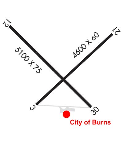
Airport Diagram might not be current. Facility Name: BURNS MUNI City Name: BURNS County: HARNEY State abbrev: OR State Name: OREGON Ownership: PUBLICLY OWNED Use: OPEN TO THE PUBLIC Owner's Name: CITY OF BURNS Address: 242 S. BROADWAY BURNS, OR 97720 Owner's Phone: 541-573-5255 Manager's Name: WALT SITZ Address: 70346 TERMINAL WAY BURNS, OR 97720 Phone: 541-589-2086; BACK UP AMGR NR (541) 589-2755. FAA Region: NORTHWEST MOUNTAIN FAA Field Office: SEA
Runway Identifications Help
Runway Identification: 03/21 Length: 4600 ftWidth: 60 ftSurface: CONCRETE-GOOD CONDITIONEdge lights: Medium Intensity Treatment: NONE Runway: 03 Runway: 21 Mag heading: 30° Mag heading: 210° Rwy Slope: -.05% Down Rwy Slope: .05% Up Approach: Approach: Pattern: Left Traffic Pattern: Left Traffic Markings: BASIC Markings: BASIC Marking Condition: GOOD Marking Condition: GOOD Arresting Dev: Arresting Dev: Lat & Long: N4335.2 W11857.6 Lat. & Long.: N4335.8 W11856.8 Elev: 4146.2 ft. MSL Elev: 4143.7 ft. MSL TCH: 36 ft. AGL TCH: 37 ft. AGL Visual Glide Path: 3.00 degrees Visual Glide Path: 3.00 degrees Displaced Threshold: 600 feet Displaced Threshold: No Touchdown Zone: YES Touchdown Zone: YES Touchdown Elev.: 4148.2 feet Touchdown Elev.: 4148.0 feet Visual Glide Slope: 2-Light PAPI on LEFT side of Runway Visual Glide Slope: 2-Light PAPI on LEFT side of Runway RVR Equipment: RVR Equipment: RVV Equipment: NO RVV Equipment: NO Approach Lights: Approach Lights: REIL: YES REIL: YES Centerline Lights: NO Centerline Lights: NO Touchdown lights: NO Touchdown lights: NO Runway Category: Runway with a Visual Approach Runway Category: Runway with a Visual Approach Declared Distances: Declared Distances: Obstructions: PLINE Obstructions: Marked: LIGHTED Marked: Clearance slope: 21:1; RWY 03 APRCH RATIO 50:1 TO DSPLCD THR. Clearance slope: 50:1 Obstruction height: 32 feet AGL Obstruction height: Dist. from runway: 900 feet Dist. from runway: Centerline offset: Centerline offset: Comments: Comments:
Runway Identification: 12/30 Length: 5101 ftWidth: 75 ftSurface: CONCRETE-GOOD CONDITIONEdge lights: Medium Intensity Treatment: NONE Runway: 12 Runway: 30 Mag heading: 117° Mag heading: 297° Rwy Slope: -.07% Down Rwy Slope: .07% Up Approach: Approach: Pattern: Left Traffic Pattern: Left Traffic Markings: BASIC Markings: NONPRECISION INSTRUMENT Marking Condition: GOOD Marking Condition: GOOD Arresting Dev: Arresting Dev: Lat & Long: N4335.8 W11857.9 Lat. & Long.: N4335.2 W11857.0 Elev: 4147.7 ft. MSL Elev: 4144.3 ft. MSL TCH: 43 ft. AGL TCH: 47 ft. AGL Visual Glide Path: 3.00 degrees Visual Glide Path: 3.00 degrees Displaced Threshold: No Displaced Threshold: No Touchdown Zone: YES Touchdown Zone: YES Touchdown Elev.: 4147.7 feet Touchdown Elev.: 4148.1 feet Visual Glide Slope: 2-Box VASI on LEFT side of Runway Visual Glide Slope: 2-Box VASI on LEFT side of Runway RVR Equipment: RVR Equipment: RVV Equipment: NO RVV Equipment: NO Approach Lights: Approach Lights: REIL: YES REIL: YES Centerline Lights: NO Centerline Lights: NO Touchdown lights: NO Touchdown lights: NO Runway Category: Runway with a Visual Approach Runway Category: Runway with a Non-precision Approach having visibility minimums greater than 3/4 mile Declared Distances: Declared Distances: Obstructions: Obstructions: ROAD Marked: Marked: NOT Marked/Lighted Clearance slope: 50:1 Clearance slope: 50:1 Obstruction height: Obstruction height: 14 feet AGL Dist. from runway: Dist. from runway: 900 feet Centerline offset: Centerline offset: 205 feet left of centerline Comments: Comments: