
| ||||||||||||||||||||||||||||||||||||||||||||
| ||||||||||||||||||||||||||||||||||||||||||||
| ||||||||||||||||||||||||||||||||||||||||||||
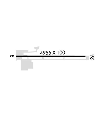
| Rwy | Rwy | |||||||
| 4955x100 | 4955' | 4955x100 | 4955' | |||||
| Runway ID | Single Wheel | Double Wheel | Double Tandem Wheel | Dual Double Wheel |
| 08/26 | 12,500 | N/A | N/A | N/A |
| These numbers are Advisory and are not limits. The Airport Manager should have more accurate Weight Limits | ||||
| FltPlan does not have IFR approach charts available for KBNG. |
 Airport Diagram might not be current. | |
| Facility Name: | BANNING MUNI |
| City Name: | BANNING |
| County: | RIVERSIDE |
| State abbrev: | CA |
| State Name: | CALIFORNIA |
| Ownership: | PUBLICLY OWNED |
| Use: | OPEN TO THE PUBLIC |
| Owner's Name: | CITY OF BANNING |
| Address: | P.O. BOX 998 |
| BANNING, CA 92220 | |
| Owner's Phone: | (951) 922-3105 |
| Manager's Name: | CARL SZOYKA |
| Address: | 176 EAST LINCOLN STREET, PO BOX 998 |
| BANNING, CA 92220-0998 | |
| Phone: | 951-922-3286 |
| FAA Region: | WESTERN-PACIFIC |
| FAA Field Office: | LAX |
| Date | Sunrise | Sunset |
|---|---|---|
| 04/22/24 Monday | 6:07 | 19:25 |
| 04/23/24 Tuesday | 6:06 | 19:26 |
| 04/24/24 Wednesday | 6:05 | 19:26 |
| 04/25/24 Thursday | 6:04 | 19:27 |
| 04/26/24 Friday | 6:03 | 19:28 |
| 04/27/24 Saturday | 6:02 | 19:29 |
| 04/28/24 Sunday | 6:01 | 19:29 |
| 04/29/24 Monday | 6:00 | 19:30 |
| 04/30/24 Tuesday | 5:59 | 19:31 |
| 05/01/24 Wednesday | 5:58 | 19:32 |
| 05/02/24 Thursday | 5:57 | 19:33 |
| 05/03/24 Friday | 5:56 | 19:33 |
| 05/04/24 Saturday | 5:55 | 19:34 |
| 05/05/24 Sunday | 5:54 | 19:35 |
| Airport Attendance Schedule | MON-FRI 0900-1530; FOR ARPT ATTENDANT CALL (951) 922-3320. |
| Airport Status | OPERATIONAL (This Status can change at any time - please check NOTAMS) |
| Airport Lighting Schedule | ACTVT MIRL RWY 08/26 - CTAF. |
| Airport Storage Available | Tie Downs |
| Extra Services Available | NONE |
| Wind Indicator | YES - (lighted) |
| Control Tower | NO |
| CTAF Frequency | 122.800 |
| Unicom Frequency | 122.800 |
| Rotating Beacon Color | WG |
| Segmented Circle | YES |
| Landing Fee | NO |
| Airport Inspected | STATE - performed by STATE AERONAUTICAL PERSONNEL |
| Inspection Date | 03/19/2024 |
| Type of Fuel Available | Grade 100LL; -10FUEL AVBL WITH 24 HR SELF SVC CREDIT CARD. FUEL APN NOT LEVEL AND ACFT MAY NOT FILL COMPLETELY. |
| Airframe Repair Service | NONE |
| Power Plant Repair Service | NONE |
| Latitude | N3355.4 |
| Longitude | W11651.1 (ESTIMATED) |
| Arpt Elevation | 2222ft (SURVEYED) |
| Magnetic Variation | 14E |
| 1 miles SE | of BANNING |
| Traffic Pattern Altitude | |
| Sectional Chart | LOS ANGELES |
| Operations (Reported) | Yearly | Avg. Daily |
|---|---|---|
| General Aviation Transient | 4121 | 11 |
| General Aviation Local | 1374 | 4 |
| Air Taxi | 0 | 0 |
| Commerical | 0 | 0 |
| Commuter | 0 | 0 |
| Military | 0 | 0 |
| Aircraft based on Field | |
|---|---|
| General Aviation Singles | 22 |
| General Aviation Multi | 2 |
| Jet Aircraft | 0 |
| General Aviation Helicopters | 1 |
| Military Aircraft | 0 |
| Gliders | 0 |
| Ultralights | 0 |
| FSS on field | NO |
| FSS tie-in | RIVERSIDE |
| FSS Phone | 1-800-WX-BRIEF |
| Who issues Notams | RAL |
| Notam D service at airport | YES |
| ARTCC Name | LOS ANGELES |
| Airport Certification | |
| Aircraft Rescue & Firefighting Index | None |
| Airport of Entry | No |
| Custom Landing Rights | No |
| Joint Civil/Military | No |
| Military Landing rights | YES |
| NATIONAL PLAN OF INTEGRATED AIRPORT SYSTEMS (NPIAS) |
| GRANT AGREEMENTS UNDER FAAP/ADAP/AIP |
| ASSURANCES PURSUANT TO TITLE VI, CIVIL RIGHTS ACT OF 1964 |
| NO INTERSECTION TAKEOFFS TO THE WEST. |
| RY 08/26 NO STRAIGHT-IN LANDINGS. |
| RWY 26 AFTER TAKEOFF AVOID OVERFLYING HOUSES 4 MILES WEST. |
| FOR CD CTC LOS ANGELES ARTCC AT 661-575-2079. |
| Runway: 08 | Runway: 26 | ||
| Mag heading: | N/A | Mag heading: | N/A |
| Rwy Slope: | -2.39% Down | Rwy Slope: | 2.39% Up |
| Approach: | Approach: | ||
| Pattern: | Left Traffic | Pattern: | Right Traffic |
| Markings: | BASIC | Markings: | BASIC |
| Marking Condition: | GOOD | Marking Condition: | GOOD |
| Arresting Dev: | Arresting Dev: | ||
| Lat & Long: | N3355.4 W11651.5 | Lat. & Long.: | N3355.3 W11650.6 |
| Elev: | 2222.4 ft. MSL | Elev: | 2103.8 ft. MSL |
| TCH: | TCH: | ||
| Visual Glide Path: | Visual Glide Path: | 3.50 degrees | |
| Displaced Threshold: | No | Displaced Threshold: | No |
| Touchdown Zone: | YES | Touchdown Zone: | YES |
| Touchdown Elev.: | 2222.4 feet | Touchdown Elev.: | 2179.2 feet |
| Visual Glide Slope: | Visual Glide Slope: | 2-Light PAPI on LEFT side of Runway | |
| RVR Equipment: | RVR Equipment: | ||
| RVV Equipment: | NO | RVV Equipment: | NO |
| Approach Lights: | Approach Lights: | ||
| REIL: | NO | REIL: | NO |
| Centerline Lights: | NO | Centerline Lights: | NO |
| Touchdown lights: | NO | Touchdown lights: | NO |
| Runway Category: | Runway with a Visual Approach | Runway Category: | Runway with a Visual Approach |
| Declared Distances: | Declared Distances: |
