Current Weather/Notams (Metars, TAFs, Notams, NWS Forecast, PIREPS, and nearby weather)
Customs Information Send updates to Support@FltPlan.com
Phone 615-365-3520Fax 615-736-7204Comments 2 hrs advance notice required. Business hrs 0800-1700 Monday-Friday. *Call prior to 1430 on preceding weekday.
Database effective 05/16/2024
Airport Diagram might not be current. Facility Name: NASHVILLE INTL City Name: NASHVILLE County: DAVIDSON State abbrev: TN State Name: TENNESSEE Ownership: PUBLICLY OWNED Use: OPEN TO THE PUBLIC Owner's Name: METRO NASHVILLE ARPT AUTH Address: 140 BNA PARK DR. SUITE 520 NASHVILLE, TN 37214 Owner's Phone: 615-275-1600 Manager's Name: ADAM FLOYD Address: 140 BNA PARK DR. SUITE 520 NASHVILLE, TN 37214 Phone: 615-275-1825 FAA Region: SOUTHERN FAA Field Office: MEM
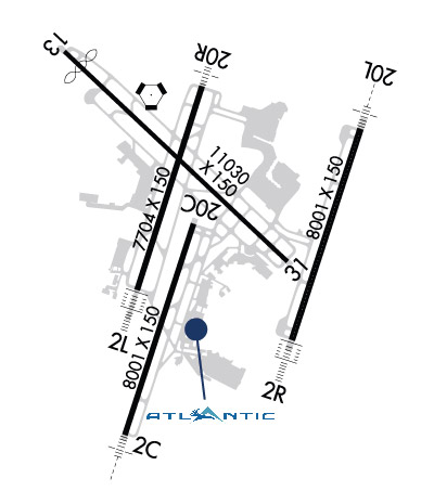
Runway Identifications Help
Runway Identification: 02C/20C Length: 8001 ftWidth: 150 ftSurface: CONCRETE-GOOD CONDITIONEdge lights: High Intensity Treatment: GROOVEDWeight: PCN 52 /R/B/W/T Runway: 02C Runway: 20C Mag heading: 21° Mag heading: 201° Rwy Slope: .03% Up Rwy Slope: -.03% Down Approach: LOC/GS Approach: Pattern: Left Traffic Pattern: Left Traffic Markings: PRECISION INSTRUMENT Markings: PRECISION INSTRUMENT Marking Condition: GOOD Marking Condition: GOOD Arresting Dev: Arresting Dev: Lat & Long: N3606.2 W08641.3 Lat. & Long.: N3607.5 W08640.8 Elev: 569.1 ft. MSL Elev: 571.8 ft. MSL TCH: TCH: 68 ft. AGL Visual Glide Path: Visual Glide Path: 3.00 degrees Displaced Threshold: No Displaced Threshold: No Touchdown Zone: YES Touchdown Zone: YES Touchdown Elev.: 586.7 feet Touchdown Elev.: 587.7 feet Visual Glide Slope: Visual Glide Slope: 4-Light PAPI on LEFT side of Runway RVR Equipment: TOUCHDOWN RVR Equipment: ROLLOUT RVV Equipment: YES RVV Equipment: YES Approach Lights: MALSR - 1,400 foot medium intensity approach lighting system with runway alignment indicator lights Approach Lights: REIL: NO REIL: YES Centerline Lights: NO Centerline Lights: NO Touchdown lights: NO Touchdown lights: NO Runway Category: Runway Category: Runway with a Non-precision Approach having visibility minimums greater than 3/4 mile Declared Distances: TORA:8001' TODA:8001' ASDA:7601' LDA:7601' Declared Distances: TORA:8001' TODA:8001' ASDA:8001' LDA:8001' Obstructions: Obstructions: Unknown Marked: Marked: NOT Marked/Lighted Clearance slope: 50:1 Clearance slope: 20:1 Obstruction height: Obstruction height: 32 feet AGL Dist. from runway: Dist. from runway: 850 feet Centerline offset: Centerline offset: Comments: Comments:
Runway Identification: 02L/20R Length: 7704 ftWidth: 150 ftSurface: CONCRETE-GOOD CONDITIONEdge lights: High Intensity Treatment: GROOVEDWeight: PCN 71 /R/B/W/T Runway: 02L Runway: 20R Mag heading: 21° Mag heading: 201° Rwy Slope: -.56% Down Rwy Slope: .56% Up Approach: ILS/DME Approach: ILS Pattern: Left Traffic Pattern: Left Traffic Markings: PRECISION INSTRUMENT Markings: PRECISION INSTRUMENT Marking Condition: GOOD Marking Condition: GOOD Arresting Dev: Arresting Dev: Lat & Long: N3607.1 W08641.2 Lat. & Long.: N3608.3 W08640.7 Elev: 598.7 ft. MSL Elev: 555.6 ft. MSL TCH: 55 ft. AGL TCH: 79 ft. AGL Visual Glide Path: 3.00 degrees Visual Glide Path: 3.00 degrees Displaced Threshold: No Displaced Threshold: No Touchdown Zone: YES Touchdown Zone: YES Touchdown Elev.: 599.0 feet Touchdown Elev.: 578.0 feet Visual Glide Slope: 4-Light PAPI on RIGHT side of Runway Visual Glide Slope: 4-Light PAPI on RIGHT side of Runway RVR Equipment: TOUCHDOWN-ROLLOUT RVR Equipment: TOUCHDOWN-ROLLOUT RVV Equipment: NO RVV Equipment: NO Approach Lights: ALSF2 - standard 2,400 foot high intensity approach lighting system with sequenced flashers, Category II or III Approach Lights: MALSF - 1,400 foot medium intensity approach lighting system with sequenced flashers REIL: NO REIL: NO Centerline Lights: YES Centerline Lights: YES Touchdown lights: YES Touchdown lights: NO Runway Category: Precision Instrument Runway Runway Category: Precision Instrument Runway Declared Distances: TORA:7702' TODA:7702' ASDA:7702' LDA:7702' Declared Distances: TORA:7702' TODA:7702' ASDA:7702' LDA:7702'
Runway Identification: 02R/20L Length: 8001 ftWidth: 150 ftSurface: CONCRETE-GOOD CONDITIONEdge lights: High Intensity Treatment: GROOVEDWeight: PCN 59 /R/B/W/T Runway: 02R Runway: 20L Mag heading: 21° Mag heading: 201° Rwy Slope: -.62% Down Rwy Slope: .62% Up Approach: ILS/DME Approach: ILS/DME Pattern: Left Traffic Pattern: Left Traffic Markings: PRECISION INSTRUMENT Markings: PRECISION INSTRUMENT Marking Condition: GOOD Marking Condition: GOOD Arresting Dev: Arresting Dev: Lat & Long: N3606.8 W08640.1 Lat. & Long.: N3608.0 W08639.6 Elev: 589.8 ft. MSL Elev: 540.0 ft. MSL TCH: TCH: Visual Glide Path: Visual Glide Path: Displaced Threshold: No Displaced Threshold: No Touchdown Zone: YES Touchdown Zone: YES Touchdown Elev.: 589.8 feet Touchdown Elev.: 550.6 feet Visual Glide Slope: Visual Glide Slope: RVR Equipment: TOUCHDOWN-MIDFIELD-ROLLOUT RVR Equipment: TOUCHDOWN-MIDFIELD-ROLLOUT RVV Equipment: NO RVV Equipment: NO Approach Lights: ALSF2 - standard 2,400 foot high intensity approach lighting system with sequenced flashers, Category II or III Approach Lights: MALSR - 1,400 foot medium intensity approach lighting system with runway alignment indicator lights REIL: NO REIL: NO Centerline Lights: YES Centerline Lights: YES Touchdown lights: YES Touchdown lights: NO Runway Category: Precision Instrument Runway Runway Category: Precision Instrument Runway Declared Distances: TORA:8000' TODA:8000' ASDA:8000' LDA:8000' Declared Distances: TORA:8000' TODA:8000' ASDA:8000' LDA:8000'
Runway Identification: 13/31 Length: 11030 ftWidth: 150 ftSurface: CONCRETE-GOOD CONDITIONEdge lights: High Intensity Treatment: GROOVEDWeight: PCN 70 /R/C/W/T Runway: 13 Runway: 31 Mag heading: 136° Mag heading: 316° Rwy Slope: .42% Up Rwy Slope: -.42% Down Approach: Approach: ILS Pattern: Left Traffic Pattern: Left Traffic Markings: PRECISION INSTRUMENT Markings: PRECISION INSTRUMENT Marking Condition: GOOD Marking Condition: GOOD Arresting Dev: Arresting Dev: Lat & Long: N3608.5 W08641.7 Lat. & Long.: N3607.2 W08640.1 Elev: 535.9 ft. MSL Elev: 582.3 ft. MSL TCH: TCH: 51 ft. AGL Visual Glide Path: Visual Glide Path: 3.00 degrees Displaced Threshold: 800 feet Displaced Threshold: 741 feet Touchdown Zone: YES Touchdown Zone: YES Touchdown Elev.: 567.5 feet Touchdown Elev.: 577.5 feet Visual Glide Slope: Visual Glide Slope: 4-Light PAPI on RIGHT side of Runway RVR Equipment: RVR Equipment: RVV Equipment: NO RVV Equipment: NO Approach Lights: Approach Lights: REIL: YES REIL: YES Centerline Lights: NO Centerline Lights: NO Touchdown lights: NO Touchdown lights: NO Runway Category: Runway with a Non-precision Approach having visibility minimums greater than 3/4 mile Runway Category: Precision Instrument Runway Declared Distances: TORA:10288' TODA:11029' ASDA:10288' LDA:9487' Declared Distances: TORA:10228' TODA:11029' ASDA:10228' LDA:9487' Obstructions: TREES Obstructions: TREE Marked: NOT Marked/Lighted Marked: NOT Marked/Lighted Clearance slope: 34:1; APCH RATIO 50:1 TO DTHR. Clearance slope: 50:1; APCH RATIO 50:1 TO DTHR. Obstruction height: Obstruction height: Dist. from runway: Dist. from runway: Centerline offset: Centerline offset: Comments: Comments: