Current Weather/Notams (Metars, TAFs, Notams, NWS Forecast, PIREPS, and nearby weather)
Customs Information Send updates to Support@FltPlan.com
Customs Not Available
Database effective 04/18/2024
Airport Diagram might not be current.
|
| Facility Name: | BEAUMONT MUNI |
| City Name: | BEAUMONT |
| County: | JEFFERSON |
| State abbrev: | TX |
| State Name: | TEXAS |
| | |
| Ownership: | PUBLICLY OWNED |
| Use: | OPEN TO THE PUBLIC |
| Owner's Name: | CITY OF BEAUMONT |
| Address: | PO BOX 3827 |
| | BEAUMONT, TX 77704 |
| Owner's Phone: | 409-880-3725 |
| | |
| Manager's Name: | CHRIS MEAUX |
| Address: | 455 KEITH RD |
| | BEAUMONT, TX 77713 |
| Phone: | 409-866-0084; AMGR CELL 409-679-0222 |
| | |
| FAA Region: | SOUTHWEST |
| FAA Field Office: | TEX |
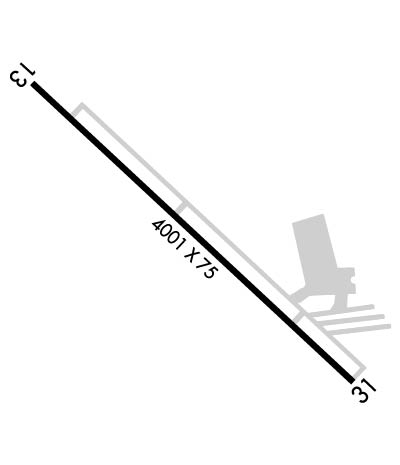
Runway Identifications
Runway Identification: 13/31Length: 4001 ft
Width: 75 ft
Surface: ASPHALT
Edge lights: Medium IntensityTreatment: NONE
| | Runway: 13 | | Runway: 31 |
| Mag heading: | 128° | Mag heading: | 308° |
| Rwy Slope: | .06% Up | Rwy Slope: | -.06% Down |
| Approach: | | Approach: | |
| Pattern: | Right Traffic | Pattern: | Left Traffic |
| Markings: | NONPRECISION INSTRUMENT | Markings: | NONPRECISION INSTRUMENT |
| Marking Condition: | GOOD | Marking Condition: | GOOD |
| Arresting Dev: | | Arresting Dev: | |
| Lat & Long: | N3004.5 W09413.2 | Lat. & Long.: | N3004.0 W09412.7 |
| Elev: | 28.8 ft. MSL | Elev: | 31.4 ft. MSL |
| TCH: | 40 ft. AGL | TCH: | 40 ft. AGL |
| Visual Glide Path: | 3.00 degrees | Visual Glide Path: | 4.00 degrees |
| Displaced Threshold: | 332 feet | Displaced Threshold: | 67 feet |
| Touchdown Zone: | YES | Touchdown Zone: | YES |
| Touchdown Elev.: | 31.2 feet | Touchdown Elev.: | 31.9 feet |
| Visual Glide Slope: | 4-Light PAPI on LEFT side of Runway | Visual Glide Slope: | 4-Light PAPI on LEFT side of Runway |
| RVR Equipment: | | RVR Equipment: | |
| RVV Equipment: | NO | RVV Equipment: | NO |
| Approach Lights: | | Approach Lights: | |
| REIL: | YES | REIL: | NO |
| Centerline Lights: | NO | Centerline Lights: | NO |
| Touchdown lights: | NO | Touchdown lights: | NO |
| Runway Category: | Runway with a Non-precision Approach | Runway Category: | Runway with a Non-precision Approach |
| Declared Distances: | | Declared Distances: | |
| Obstructions: | PLINE; ALSO, 45 FT PLINE, 745 FT DSTC, 300 FT L, 12:1 AT RWY END, 23:1 TO DSPLCD THR. | Obstructions: | ROAD |
| Marked: | NOT Marked/Lighted | Marked: | NOT Marked/Lighted |
| Clearance slope: | 12:1; APCH SLOPE 23:1 TO DSPLCD THR. | Clearance slope: | 10:1; APCH SLOPE 16:1 TO DSPLCD THR OVR 54 FT TREE, 900 FT DSTC. |
| Obstruction height: | 45 feet AGL | Obstruction height: | 15 feet AGL |
| Dist. from runway: | 745 feet | Dist. from runway: | 350 feet |
| Centerline offset: | 300 left of centerline | Centerline offset: | 260 feet right of centerline |
| Comments: | | Comments: | |

