
| ||||||||||||||||||||||||||||||||||||||||||||
| ||||||||||||||||||||||||||||||||||||||||||||
| ||||||||||||||||||||||||||||||||||||||||||||
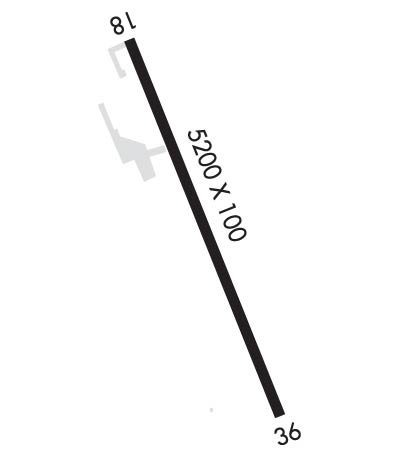
| Rwy | Rwy | |||||||
| 5200x100 | 5200' | 5200x100 | 5200' | |||||
| Runway ID | Single Wheel | Double Wheel | Double Tandem Wheel | Dual Double Wheel |
| 18/36 | 53,000 | 82,000 | 140,000 | N/A |
| These numbers are Advisory and are not limits. The Airport Manager should have more accurate Weight Limits | ||||
 Airport Diagram might not be current. | |
| Facility Name: | BERLIN RGNL |
| City Name: | BERLIN |
| County: | COOS |
| State abbrev: | NH |
| State Name: | NEW HAMPSHIRE |
| Ownership: | PUBLICLY OWNED |
| Use: | OPEN TO THE PUBLIC |
| Owner's Name: | CITY OF BERLIN |
| Address: | 168 MAIN ST |
| BERLIN, NH 03570 | |
| Owner's Phone: | 603-752-7532 |
| Manager's Name: | MARCEL LEVEILLE |
| Address: | 800 EAST SIDE RIVER RD. |
| MILAN, NH 03588 | |
| Phone: | 603-449-2168; AMGR AFT HRS FONE 603-915-0214. |
| FAA Region: | NEW ENGLAND |
| FAA Field Office: | NONE |
| Date | Sunrise | Sunset |
|---|---|---|
| 04/18/24 Thursday | 5:54 | 19:34 |
| 04/19/24 Friday | 5:53 | 19:35 |
| 04/20/24 Saturday | 5:51 | 19:37 |
| 04/21/24 Sunday | 5:49 | 19:38 |
| 04/22/24 Monday | 5:48 | 19:39 |
| 04/23/24 Tuesday | 5:46 | 19:40 |
| 04/24/24 Wednesday | 5:45 | 19:42 |
| 04/25/24 Thursday | 5:43 | 19:43 |
| 04/26/24 Friday | 5:41 | 19:44 |
| 04/27/24 Saturday | 5:40 | 19:45 |
| 04/28/24 Sunday | 5:38 | 19:47 |
| 04/29/24 Monday | 5:37 | 19:48 |
| 04/30/24 Tuesday | 5:35 | 19:49 |
| 05/01/24 Wednesday | 5:34 | 19:50 |
| Airport Attendance Schedule | 7 Days A Week 0800-1600 |
| Airport Status | OPERATIONAL (This Status can change at any time - please check NOTAMS) |
| Airport Lighting Schedule | ACTVT REIL RWY 18 & 36, PAPI RWY 18, HIRL RWY 18/36 - CTAF. |
| Airport Storage Available | Tie Downs |
| Extra Services Available | NONE |
| Wind Indicator | YES - (lighted) |
| Control Tower | NO |
| CTAF Frequency | 122.700 |
| Unicom Frequency | 122.700 |
| Rotating Beacon Color | WG |
| Segmented Circle | NO |
| Landing Fee | NO; CORPORATE AND CHTR ACFT LDG FEE FOR ALL PISTON, TURBOPROP & JET ACFT. LDG FEE WAIVED WITH FUEL PURCHASE & OVNGT PRKG, CORPORATE & CHTR ACFT OVNGT PRKG FEE. CTC AMGR. |
| Airport Inspected | STATE - performed by STATE AERONAUTICAL PERSONNEL |
| Inspection Date | 08/29/2023 |
| Type of Fuel Available | Grade 100LL, JET A (freeze point -40C); -10SELF-SERVE 100LL AVBL 24 HRS WITH CREDIT CARD SYSTEM. FOR JET A AFTER HRS CALL 603-915-0214. |
| Airframe Repair Service | MINOR |
| Power Plant Repair Service | MINOR |
| Latitude | N4434.5 |
| Longitude | W07110.6 (ESTIMATED) |
| Arpt Elevation | 1161ft (SURVEYED) |
| Magnetic Variation | 16W |
| 7 miles N | of BERLIN |
| Traffic Pattern Altitude | |
| Sectional Chart | MONTREAL |
| Operations (Reported) | Yearly | Avg. Daily |
|---|---|---|
| General Aviation Transient | 1500 | 4 |
| General Aviation Local | 2000 | 5 |
| Air Taxi | 10 | 0 |
| Commerical | 0 | 0 |
| Commuter | 0 | 0 |
| Military | 50 | 0 |
| Aircraft based on Field | |
|---|---|
| General Aviation Singles | 10 |
| General Aviation Multi | 0 |
| Jet Aircraft | 0 |
| General Aviation Helicopters | 0 |
| Military Aircraft | 0 |
| Gliders | 0 |
| Ultralights | 1 |
| FSS on field | NO |
| FSS tie-in | BANGOR |
| FSS Phone | 1-800-WX-BRIEF |
| Who issues Notams | BML |
| Notam D service at airport | YES |
| ARTCC Name | BOSTON |
| Airport Certification | |
| Aircraft Rescue & Firefighting Index | None |
| Airport of Entry | No |
| Custom Landing Rights | No |
| Joint Civil/Military | No |
| Military Landing rights | YES |
| NATIONAL PLAN OF INTEGRATED AIRPORT SYSTEMS (NPIAS) |
| GRANT AGREEMENTS UNDER FAAP/ADAP/AIP |
| ASSURANCES PURSUANT TO TITLE VI, CIVIL RIGHTS ACT OF 1964 |
| AGREEMENT UNDER DLAND OR DCLA HAS EXPIRED. |
| OBSTN LGTS ON ANT POLES; HAZARD BCNS ON SURROUNDING HILLS. |
| WILDLIFE ON & INVOF ARPT. |
| COLD TEMPERATURE AIRPORT. ALTITUDE CORRECTION REQUIRED AT OR BELOW -29C. |
| FOR CD IF UNA TO CTC ON FSS FREQ, CTC BOSTON ARTCC AT 603-879-6859. |
| RENTAL CARS & CATERING AVBL BY REQ, CALL 603-915-0214. |
Airport Communications & Frequencies:
| |||||||||
| Runway: 18 | Runway: 36 | ||
| Mag heading: | 175° | Mag heading: | 355° |
| Rwy Slope: | -.59% Down | Rwy Slope: | .59% Up |
| Approach: | Approach: | ||
| Pattern: | Left Traffic | Pattern: | Left Traffic |
| Markings: | NONPRECISION INSTRUMENT | Markings: | NONPRECISION INSTRUMENT |
| Marking Condition: | GOOD | Marking Condition: | GOOD |
| Arresting Dev: | Arresting Dev: | ||
| Lat & Long: | N4434.9 W07110.8 | Lat. & Long.: | N4434.1 W07110.3 |
| Elev: | 1161.3 ft. MSL | Elev: | 1130.4 ft. MSL |
| TCH: | 65 ft. AGL | TCH: | |
| Visual Glide Path: | 3.50 degrees | Visual Glide Path: | |
| Displaced Threshold: | No | Displaced Threshold: | No |
| Touchdown Zone: | YES | Touchdown Zone: | YES |
| Touchdown Elev.: | 1161.3 feet | Touchdown Elev.: | 1130.4 feet |
| Visual Glide Slope: | 4-Light PAPI on LEFT side of Runway | Visual Glide Slope: | |
| RVR Equipment: | RVR Equipment: | ||
| RVV Equipment: | NO | RVV Equipment: | NO |
| Approach Lights: | Approach Lights: | ||
| REIL: | YES | REIL: | YES |
| Centerline Lights: | NO | Centerline Lights: | NO |
| Touchdown lights: | NO | Touchdown lights: | NO |
| Runway Category: | Runway with a Non-precision Approach having visibility minimums greater than 3/4 mile | Runway Category: | Runway with a Visual Approach |
| Declared Distances: | Declared Distances: | ||
| Obstructions: | TREES | Obstructions: | TREES |
| Marked: | NOT Marked/Lighted | Marked: | NOT Marked/Lighted |
| Clearance slope: | 10:1 | Clearance slope: | 1:1 |
| Obstruction height: | 55 feet AGL | Obstruction height: | 18 feet AGL |
| Dist. from runway: | 799 feet | Dist. from runway: | 235 feet |
| Centerline offset: | 290 left of centerline | Centerline offset: | 235 feet left of centerline |
| Comments: | Comments: |
