Approach Charts
| FltPlan does not have IFR approach charts available for KBLU. |
Current Weather/Notams (Metars, TAFs, Notams, NWS Forecast, PIREPS, and nearby weather)
Customs Information Send updates to Support@FltPlan.com
Customs Not Available
Database effective 04/18/2024
Airport Diagram might not be current.
|
| Facility Name: | BLUE CANYON - NYACK |
| City Name: | EMIGRANT GAP |
| County: | PLACER |
| State abbrev: | CA |
| State Name: | CALIFORNIA |
| | |
| Ownership: | PUBLICLY OWNED |
| Use: | OPEN TO THE PUBLIC |
| Owner's Name: | COUNTY OF PLACER |
| Address: | 3091 COUNTY CTR DR. |
| | AUBURN, CA 95603 |
| Owner's Phone: | 530-745-7500 |
| | |
| Manager's Name: | KEVIN ORDWAY |
| Address: | 3091 COUNTY CTR DR. SUITE 220 |
| | AUBURN, CA 95603 |
| Phone: | 530-745-3576; LOCATED AT DEPT OF PUBLIC WORKS OFFICE, AUBURN, CA. |
| | |
| FAA Region: | WESTERN-PACIFIC |
| FAA Field Office: | SFO |
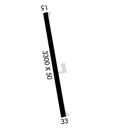
Runway Identifications
Runway Identification: 15/33Length: 3300 ft
Width: 50 ft
Surface: ASPHALT-GOOD CONDITION
Edge lights: Medium IntensityTreatment: NONE
| | Runway: 15 | | Runway: 33 |
| Mag heading: | N/A | Mag heading: | N/A |
| Rwy Slope: | -1.14% Down | Rwy Slope: | 1.14% Up |
| Approach: | | Approach: | |
| Pattern: | Left Traffic | Pattern: | Left Traffic |
| Markings: | BASIC | Markings: | BASIC |
| Marking Condition: | GOOD | Marking Condition: | GOOD |
| Arresting Dev: | | Arresting Dev: | |
| Lat & Long: | N3916.8 W12042.7 | Lat. & Long.: | N3916.2 W12042.5 |
| Elev: | 5283.5 ft. MSL | Elev: | 5245.9 ft. MSL |
| TCH: | | TCH: | |
| Visual Glide Path: | | Visual Glide Path: | |
| Displaced Threshold: | No | Displaced Threshold: | No |
| Touchdown Zone: | NO | Touchdown Zone: | NO |
| Touchdown Elev.: | | Touchdown Elev.: | |
| Visual Glide Slope: | | Visual Glide Slope: | |
| RVR Equipment: | | RVR Equipment: | |
| RVV Equipment: | NO | RVV Equipment: | NO |
| Approach Lights: | | Approach Lights: | |
| REIL: | NO | REIL: | NO |
| Centerline Lights: | NO | Centerline Lights: | NO |
| Touchdown lights: | NO | Touchdown lights: | NO |
| Runway Category: | Runway with a Visual Approach | Runway Category: | Runway with a Visual Approach |
| Declared Distances: | | Declared Distances: | |
| Obstructions: | TREE | Obstructions: | TREE |
| Marked: | NOT Marked/Lighted | Marked: | NOT Marked/Lighted |
| Clearance slope: | 27:1 | Clearance slope: | 13:1 |
| Obstruction height: | 20 feet AGL | Obstruction height: | 15 feet AGL |
| Dist. from runway: | 750 feet | Dist. from runway: | 400 feet |
| Centerline offset: | 110 left of centerline | Centerline offset: | |
| Comments: | RWY 15 +4 FT BRUSH 100 FT FM THLD 125 FT LEFT TO 125 FT RIGHT | Comments: | |

