| |||||||||||||||||||||||||||||||||||||||||||||||||||||||||||||
| |||||||||||||||||||||||||||||||||||||||||||||||||||||||||||||
| |||||||||||||||||||||||||||||||||||||||||||||||||||||||||||||
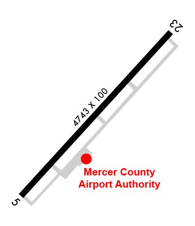
| Rwy | Rwy | |||||||
| 4743x100 | 4743' | 4743x100 | 4743' | 109.50 - 228° | ||||
| Runway ID | Single Wheel | Double Wheel | Double Tandem Wheel | Dual Double Wheel |
| 05/23 | 30,000 | 48,000 | N/A | N/A |
| These numbers are Advisory and are not limits. The Airport Manager should have more accurate Weight Limits | ||||
 Airport Diagram might not be current. | |
| Facility Name: | MERCER COUNTY |
| City Name: | BLUEFIELD |
| County: | MERCER |
| State abbrev: | WV |
| State Name: | WEST VIRGINIA |
| Ownership: | PUBLICLY OWNED |
| Use: | OPEN TO THE PUBLIC |
| Owner's Name: | MERCER CO ARPT AUTH INC |
| Address: | 300 MARKELL DR. STE 201 |
| BLUEFIELD, WV 24701 | |
| Owner's Phone: | 304-327-5308 |
| Manager's Name: | JIM PILKINS |
| Address: | 300 MARKELL DR. STE 201 |
| BLUEFIELD, WV 24701 | |
| Phone: | 304-327-5308; MGR CELL 304-921-3417. |
| FAA Region: | EASTERN |
| FAA Field Office: | BKW |
| Date | Sunrise | Sunset |
|---|---|---|
| 04/17/24 Wednesday | 6:47 | 20:02 |
| 04/18/24 Thursday | 6:45 | 20:03 |
| 04/19/24 Friday | 6:44 | 20:04 |
| 04/20/24 Saturday | 6:43 | 20:05 |
| 04/21/24 Sunday | 6:41 | 20:06 |
| 04/22/24 Monday | 6:40 | 20:07 |
| 04/23/24 Tuesday | 6:39 | 20:08 |
| 04/24/24 Wednesday | 6:37 | 20:09 |
| 04/25/24 Thursday | 6:36 | 20:10 |
| 04/26/24 Friday | 6:35 | 20:11 |
| 04/27/24 Saturday | 6:34 | 20:11 |
| 04/28/24 Sunday | 6:33 | 20:12 |
| 04/29/24 Monday | 6:31 | 20:13 |
| 04/30/24 Tuesday | 6:30 | 20:14 |
| Airport Attendance Schedule | 7 Days A Week 0600-2100; ARPT UNATND CHRISTMAS & NEW YEARS. FOR SVCS CALL 304-921-3417 (LINE STAFF CELL). |
| Airport Status | OPERATIONAL (This Status can change at any time - please check NOTAMS) |
| Airport Lighting Schedule | ACTVT REIL RWY 05 & 23; PAPI RWY 05 & 23; HIRL RWY 05/23; TWY LIGHTS - CTAF. |
| Airport Storage Available | Tie Downs, Hanger |
| Extra Services Available | Flight Instruction |
| Wind Indicator | YES - (lighted) |
| Control Tower | NO |
| CTAF Frequency | 122.900 |
| Unicom Frequency | |
| Rotating Beacon Color | WG |
| Segmented Circle | NO |
| Landing Fee | NO |
| Airport Inspected | STATE - performed by PRIVATE CONTRACT PERSONNEL |
| Inspection Date | 07/11/2023 |
| Type of Fuel Available | Grade 100LL, JET A (freeze point -40C), JET A; -1024 HR SELF-SERVE FUEL. FUEL ALSO AVBL BY TRUCK DRG ATND HRS OR AFTR HRS BY PRIOR ARGMNT, $75 CALL-OUT FEE. LINE OFC PH 304-327-8440. |
| Airframe Repair Service | MAJOR; ROTARY WING REPAIRS ONLY. FIXED WING RPRS AVBL ON CALL, CTC AMGR. |
| Power Plant Repair Service | MAJOR; ROTARY WING REPAIRS ONLY. FIXED WING RPRS AVBL ON CALL, CTC AMGR. |
| Latitude | N3717.8 |
| Longitude | W08112.5 (ESTIMATED) |
| Arpt Elevation | 2856ft (SURVEYED) |
| Magnetic Variation | 07W |
| 3 miles NE | of BLUEFIELD |
| Traffic Pattern Altitude | |
| Sectional Chart | CINCINNATI |
| Operations (Reported) | Yearly | Avg. Daily |
|---|---|---|
| General Aviation Transient | 10000 | 27 |
| General Aviation Local | 4500 | 12 |
| Air Taxi | 1800 | 5 |
| Commerical | 0 | 0 |
| Commuter | 0 | 0 |
| Military | 100 | 0 |
| Aircraft based on Field | |
|---|---|
| General Aviation Singles | 16 |
| General Aviation Multi | 1 |
| Jet Aircraft | 0 |
| General Aviation Helicopters | 5 |
| Military Aircraft | 0 |
| Gliders | 0 |
| Ultralights | 1 |
| FSS on field | NO |
| FSS tie-in | ELKINS |
| FSS Phone | 1-800-WX-BRIEF |
| Who issues Notams | BLF |
| Notam D service at airport | YES |
| ARTCC Name | INDIANAPOLIS |
| Airport Certification | |
| Aircraft Rescue & Firefighting Index | None |
| Airport of Entry | No |
| Custom Landing Rights | No |
| Joint Civil/Military | No |
| Military Landing rights | YES |
| NATIONAL PLAN OF INTEGRATED AIRPORT SYSTEMS (NPIAS) |
| GRANT AGREEMENTS UNDER FAAP/ADAP/AIP |
| COMPLIANCE WITH ACCESSIBILITY TO THE HANDICAPPED |
| ASSURANCES PURSUANT TO TITLE VI, CIVIL RIGHTS ACT OF 1964 |
| MOWING IN PROGRESS APR-NOV ALL SFCS. |
| DEER & BIRDS ON & INVOF ARPT. |
| RWY 23 HAS STEEP DROP-OFF 320 FT FM THR 0B, 280 FT L AND R. |
| RWY 05 HAS STEEP DROP-OFF 175 FT FM THR L SIDE. |
| FOR CD IF UNA TO CTC ON FSS FREQ, CTC INDIANAPOLIS ARTCC AT 317-247-2411. |
Airport Communications & Frequencies:
| |||||||
| Runway: 05 | Runway: 23 | ||
| Mag heading: | 49° | Mag heading: | 229° |
| Rwy Slope: | .13% Up | Rwy Slope: | -.13% Down |
| Approach: | Approach: | ILS | |
| Pattern: | Left Traffic | Pattern: | Left Traffic |
| Markings: | NONPRECISION INSTRUMENT | Markings: | PRECISION INSTRUMENT |
| Marking Condition: | FAIR | Marking Condition: | FAIR |
| Arresting Dev: | Arresting Dev: | ||
| Lat & Long: | N3717.5 W08112.8 | Lat. & Long.: | N3718.0 W08112.1 |
| Elev: | 2850.2 ft. MSL | Elev: | 2856.4 ft. MSL |
| TCH: | 40 ft. AGL | TCH: | 65 ft. AGL |
| Visual Glide Path: | 3.00 degrees | Visual Glide Path: | 3.00 degrees |
| Displaced Threshold: | No | Displaced Threshold: | No |
| Touchdown Zone: | YES | Touchdown Zone: | YES |
| Touchdown Elev.: | 2850.2 feet | Touchdown Elev.: | 2856.7 feet |
| Visual Glide Slope: | 4-Light PAPI on LEFT side of Runway | Visual Glide Slope: | 4-Light PAPI on LEFT side of Runway |
| RVR Equipment: | RVR Equipment: | ||
| RVV Equipment: | NO | RVV Equipment: | NO |
| Approach Lights: | Approach Lights: | ||
| REIL: | YES | REIL: | YES |
| Centerline Lights: | NO | Centerline Lights: | NO |
| Touchdown lights: | NO | Touchdown lights: | NO |
| Runway Category: | Runway with a Non-precision Approach having visibility minimums greater than 3/4 mile | Runway Category: | Precision Instrument Runway |
| Declared Distances: | TORA:4743' TODA:4743' ASDA:4743' LDA:4743' | Declared Distances: | TORA:4743' TODA:4743' ASDA:4743' LDA:4743' |
| Obstructions: | TREES | Obstructions: | TREES |
| Marked: | NOT Marked/Lighted | Marked: | NOT Marked/Lighted |
| Clearance slope: | Clearance slope: | ||
| Obstruction height: | 35 feet AGL | Obstruction height: | 40 feet AGL |
| Dist. from runway: | 201 feet | Dist. from runway: | 201 feet |
| Centerline offset: | 330 right of centerline | Centerline offset: | 300 feet right of centerline |
| Comments: | 35 FT TREES, UP TO 199 FT DSTC, 300 FT RIGHT. | Comments: | 40 FT TREES, 0 FT DSTC, 300 FT R. |