Click here for more info on on SMS!

KBKX

BROOKINGS RGNL
BROOKINGS
SD
Time Zone: Central
Lat: N 4418.3
Long: W 09649.1
Elev: 1648
Var: -03
Longest Runway: 6000
AWOS: 119.92
CTAF: 123.0

FBO & Flight Services info for KBKX

FBOs: Update your Fuel Prices

  click here  
We offer our clients nothing but the best service for your passengers, crew & aircraft. We'll take care of your hotel accommodations, rental vehicle, catering service or any other service you may require. We offer heated hangar, a lounge with big screen TV, a computer room with internet & weather info, onsite vending machines & kitchen, courtesy van, & conference rooms (available upon request).
Ph: 605-692-2779 Fax: 605-692-8567 Freq: 123.0WebsiteE-Mail
                                         
Service
Jet
100LL
SAF
MoGas
Fuel Avail: PRIST PREMIXED. M-F 0900 to 1700 CDT SS 0900 to 1500
Full6.256.90    Last Update: 04/08/2024 09:35

Self6.256.90    
Misc. Info: Address: 307 2ND STREET SW,   BROOKINGS, SD 57006

AWOSPh: 605-692-1809
-
Freq: 119.92  
If you are an FBO, call 1-203-262-1700 to update your info or email: FltPlan.Advertising@garmin.com
Advertise your FBO on FltPlan.com

Runway & Approach Info for KBKX
Rwy
Length
Land Dist**
Approach*
  Rwy
Length
Land Dist**
Approach*
12
6000x100  6000'          
ILS/DME
 111.35 - 115°  
  
30
  6000x100  6000'          
 
17
3600x60  3600'          
 
  
35
  3600x60  3600'          
 
 * only ILS, LOC, LDA, and SDF approaches to a specific runway are shown
** For any Declared Landing Distance Available, please see A/FD or Approach plates
Runway Weight Capability (lbs.) Help
Runway IDSingle WheelDouble WheelDouble Tandem WheelDual Double Wheel
12/3044,00061,00086,000N/A
17/3512,500N/AN/AN/A
These numbers are Advisory and are not limits.   The Airport Manager should have more accurate Weight Limits
Approach Charts
Approaches    
Current Weather/Notams
Customs Information Send updates to Support@FltPlan.com
Customs Not Available
Database effective 05/16/2024
Airport Diagram of KBKX
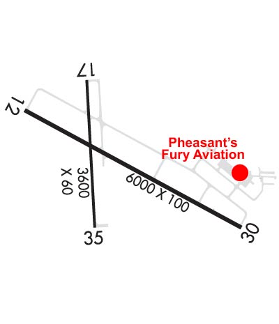
Airport Diagram might not be current.

Facility Name: BROOKINGS RGNL
City Name: BROOKINGS
County: BROOKINGS
State abbrev: SD
State Name: SOUTH DAKOTA
   
Ownership: PUBLICLY OWNED
Use: OPEN TO THE PUBLIC
Owner's Name: CITY OF BROOKINGS
Address: 520 3RD STREET, SUITE 140, PO BOX 270
 BROOKINGS, SD 57006
Owner's Phone: 605-692-6955
  
Manager's Name: LUCAS DAHL
Address: 509 W SECOND STREET
 BROOKINGS, SD 57006
Phone: 605-697-8664
   
FAA Region: GREAT LAKES
FAA Field Office: DMA


Sunrise / Sunset times for BROOKINGS RGNL

DateSunriseSunset
04/23/24 Tuesday6:2920:23
04/24/24 Wednesday6:2820:24
04/25/24 Thursday6:2620:25
04/26/24 Friday6:2420:26
04/27/24 Saturday6:2320:27
04/28/24 Sunday6:2120:29
04/29/24 Monday6:2020:30
04/30/24 Tuesday6:1820:31
05/01/24 Wednesday6:1720:32
05/02/24 Thursday6:1620:33
05/03/24 Friday6:1420:35
05/04/24 Saturday6:1320:36
05/05/24 Sunday6:1120:37
05/06/24 Monday6:1020:38

Airport Facilities

Airport Attendance Schedule7 Days A Week 0800-1800
Airport Status OPERATIONAL (This Status can change at any time - please check NOTAMS)
Airport Lighting ScheduleACTVT MALSR RWY 12; REIL RWY 17, 30, 35; PAPI RWY 12, 17, 30, 35; HIRL RWY 12/30; MIRL RWY 17/35 - CTAF
Airport Storage AvailableTie Downs, Hanger
Extra Services AvailableCrop Dusting, Charter, Flight Instruction, Aircraft Rental
Wind IndicatorYES - (lighted)
Control TowerNO
CTAF Frequency123.000
Unicom Frequency123.000
Rotating Beacon ColorWG
Segmented CircleNO
Landing FeeNO

Airport Inspection Data

Airport InspectedFEDERAL - performed by STATE AERONAUTICAL PERSONNEL
Inspection Date04/18/2023

Airport Services

Type of Fuel AvailableGrade 100LL, JET A (freeze point -40C)
Airframe Repair ServiceMAJOR
Power Plant Repair ServiceMAJOR

Geographic Data

LatitudeN4418.3
LongitudeW09649.1 (ESTIMATED)
Arpt Elevation1647ft (SURVEYED)
Magnetic Variation03E
0 miles SWof BROOKINGS
Traffic Pattern Altitude
Sectional ChartOMAHA

Aircraft Data

Operations (Reported)YearlyAvg. Daily
General Aviation Transient 5001
General Aviation Local 3100085
Air Taxi 4251
Commerical 00
Commuter 00
Military 1000
Aircraft based on Field
General Aviation Singles 54
General Aviation Multi 5
Jet Aircraft 1
General Aviation Helicopters 0
Military Aircraft 0
Gliders 3
Ultralights 0

FAA Services

FSS on field NO
FSS tie-in HURON
FSS Phone 1-800-WX-BRIEF
Who issues Notams BKX
Notam D service at airport YES
ARTCC Name MINNEAPOLIS

Federal Status

Airport Certification
Aircraft Rescue & Firefighting IndexNone
Airport of EntryNo
Custom Landing RightsNo
Joint Civil/MilitaryNo
Military Landing rightsYES

Federal Agreements

NATIONAL PLAN OF INTEGRATED AIRPORT SYSTEMS (NPIAS)
GRANT AGREEMENTS UNDER FAAP/ADAP/AIP
ASSURANCES PURSUANT TO TITLE VI, CIVIL RIGHTS ACT OF 1964

Remarks

INTENSIVE STUDENT TRAINING.
FOR CD IF UNA TO CTC ON FSS FREQ, CTC MINNEAPOLIS ARTCC AT 651-463-5588.
AIRFIELD CONDS NOT MNTD BTN 1900 - 0700 HRS LCL TIME.
RWY 30 IS PREFERRED RWY WHEN WNDS ARE CALM.
LARGE FLOCKS OF GEESE & GULLS ON & INVOF ARPT APR THRU OCT.
FOR ATTENDANT AFT HRS CALL 605-692-2779 OR 605-690-6013.
GCO AVBL ON FREQ 121.725 (4 CLICKS TO MINNEAPOLIS CENTER, 6 CLICKS TO FLT SVC)
Airport Communications & Frequencies:
CTAF Frequency:
123.000
Unicom Frequency:
123.000
Remarks
  • APCH/DEP SVC PRVDD BY MINNEAPOLIS ARTCC (ZMP) ON FREQS 132.05/317.4 (SIOUX FALLS RCAG).
  • Runway Identifications
    Runway Identification: 12/30
    Length: 6000 ft
    Width: 100 ft
    Surface: ASPHALT
    Edge lights: High Intensity

    Treatment: GROOVED
    Weight: PCN 39 /F/D/X/T

     Runway: 12   Runway: 30
    Mag heading: 116°Mag heading: 296°
    Rwy Slope: .57% UpRwy Slope: -.57% Down
    Approach: ILS/DMEApproach:
    Pattern: Left TrafficPattern: Left Traffic
    Markings: PRECISION INSTRUMENTMarkings: PRECISION INSTRUMENT
    Marking Condition: GOODMarking Condition: GOOD
    Arresting Dev: Arresting Dev:
    Lat & Long: N4418.5  W09649.7Lat. & Long.: N4418.0  W09648.4
    Elev: 1602.6 ft. MSLElev: 1636.7 ft. MSL
    TCH: 50 ft. AGLTCH: 35 ft. AGL
    Visual Glide Path: 3.00 degreesVisual Glide Path: 3.00 degrees
    Displaced Threshold: NoDisplaced Threshold: No
    Touchdown Zone: YESTouchdown Zone: YES
    Touchdown Elev.: 1620.6 feetTouchdown Elev.: 1636.7 feet
    Visual Glide Slope: 4-Light PAPI on LEFT side of RunwayVisual Glide Slope: 4-Light PAPI on LEFT side of Runway
    RVR Equipment: RVR Equipment:
    RVV Equipment: NORVV Equipment: NO
    Approach Lights: MALSR - 1,400 foot medium intensity approach lighting system with runway alignment indicator lightsApproach Lights:
    REIL: NOREIL: YES
    Centerline Lights: NOCenterline Lights: NO
    Touchdown lights: NOTouchdown lights: NO
    Runway Category: Precision Instrument RunwayRunway Category: Runway with a Non-precision Approach having visibility minimums greater than 3/4 mile
    Declared Distances: TORA:6000' TODA:6000' ASDA:6000' LDA:6000'Declared Distances: TORA:6000' TODA:6000' ASDA:6000' LDA:6000'
    Runway Identification: 17/35
    Length: 3600 ft
    Width: 60 ft
    Surface: ASPHALT
    Edge lights: Medium Intensity

    Treatment: NONE
    Weight: PCN 27 /F/D/X/T

     Runway: 17   Runway: 35
    Mag heading: 174°Mag heading: 354°
    Rwy Slope: 1.00% UpRwy Slope: -1.00% Down
    Approach: Approach:
    Pattern: Left TrafficPattern: Left Traffic
    Markings: NONPRECISION INSTRUMENTMarkings: NONPRECISION INSTRUMENT
    Marking Condition: GOODMarking Condition: GOOD
    Arresting Dev: Arresting Dev:
    Lat & Long: N4418.6  W09649.3Lat. & Long.: N4418.0  W09649.3
    Elev: 1609.8 ft. MSLElev: 1645.9 ft. MSL
    TCH: 25 ft. AGLTCH: 24 ft. AGL
    Visual Glide Path: 3.00 degreesVisual Glide Path: 3.00 degrees
    Displaced Threshold: NoDisplaced Threshold: No
    Touchdown Zone: YESTouchdown Zone: YES
    Touchdown Elev.: 1635.2 feetTouchdown Elev.: 1647.5 feet
    Visual Glide Slope: 2-Light PAPI on LEFT side of RunwayVisual Glide Slope: 2-Light PAPI on LEFT side of Runway
    RVR Equipment: RVR Equipment:
    RVV Equipment: NORVV Equipment: NO
    Approach Lights: Approach Lights:
    REIL: YESREIL: YES
    Centerline Lights: NOCenterline Lights: NO
    Touchdown lights: NOTouchdown lights: NO
    Runway Category: Runway with a Visual ApproachRunway Category: Runway with a Visual Approach
    Declared Distances: TORA:3600' TODA:3600' ASDA:3600' LDA:3600'Declared Distances: TORA:3600' TODA:3600' ASDA:3600' LDA:3600'
    C:7/P: