KBKW

RALEIGH COUNTY MEMORIAL
BECKLEY
WV
Time Zone: Eastern
Lat: N 3747.2
Long: W 08107.5
Elev: 2504
Var: +06
Longest Runway: 6750
AWOS: 121.55
CTAF: 123.0

FBO & Flight Services info for KBKW

FBOs: Update your Fuel Prices

RALEIGH CO ARPTPh: 304-255-0476 Fax: 304-253-2095 Freq: 123.0
Service
Jet
100LL
SAF
MoGas
Fuel Avail: PRIST PREMIXED. 24/7
Full5.606.75    Last Update: 04/17/2024 17:56

Call ahead for daily fuel prices
Self        
 Address: 176 AIRPORT CIR ROOM 115   BEAVER, WV 25813
ASOSPh: 304-253-5214
-
Freq: 121.55  
If you are an FBO, call 1-203-262-1700 to update your info or email: FltPlan.Advertising@garmin.com
Advertise your FBO on FltPlan.com
FBOs at nearby airports who want your business:
KLWB

  click here  
We offer GROUND TRANSPORTATION SERVICES and HEATED HANGAR AIRCRAFT STORAGE. Enjoy a fresh cup of coffee from our complimentary coffee bar while relaxing in our lobby with a wide screen tv, wifi, and massage chair. Jet America also offers maintenance for your aircraft and 30 yrs experience to assist you with your aircraft acquisition or sale.
Ph: 1-304-647-4888WebsiteE-MailFax: 1-304-647-4887Freq: 000.00

Runway & Approach Info for KBKW
Rwy
Length
Land Dist**
Approach*
  Rwy
Length
Land Dist**
Approach*
01
6750x150  6750'          
 
  
19
  6750x150  6750'          
ILS
 111.70 - 193°  
10
5001x100  5001'          
 
  
28
  5001x100  5001'          
 
 * only ILS, LOC, LDA, and SDF approaches to a specific runway are shown
** For any Declared Landing Distance Available, please see A/FD or Approach plates
Runway Weight Capability (lbs.) Help
Runway IDSingle WheelDouble WheelDouble Tandem WheelDual Double Wheel
01/1975,000150,000200,000N/A
10/2845,00060,000N/AN/A
These numbers are Advisory and are not limits.   The Airport Manager should have more accurate Weight Limits
Approach Charts
Approaches    
Current Weather/Notams
Customs Information Send updates to Support@FltPlan.com
Customs Not Available
Database effective 04/18/2024
Airport Diagram of KBKW
Airport Diagram might not be current.

Facility Name: RALEIGH COUNTY MEML
City Name: BECKLEY
County: RALEIGH
State abbrev: WV
State Name: WEST VIRGINIA
   
Ownership: PUBLICLY OWNED
Use: OPEN TO THE PUBLIC
Owner's Name: RALEIGH COUNTY ARPT AUTH
Address: 176 AIRPORT CIRCLE RM 105
 BEAVER, WV 25813
Owner's Phone: 304-255-0476
  
Manager's Name: TOM COCHRAN
Address: 176 AIRPORT CIRCLE RM 105
 BEAVER, WV 25813
Phone: 304-255-0476
   
FAA Region: EASTERN
FAA Field Office: BKW


Sunrise / Sunset times for RALEIGH COUNTY MEML

DateSunriseSunset
04/19/24 Friday6:4320:05
04/20/24 Saturday6:4220:06
04/21/24 Sunday6:4020:06
04/22/24 Monday6:3920:07
04/23/24 Tuesday6:3820:08
04/24/24 Wednesday6:3620:09
04/25/24 Thursday6:3520:10
04/26/24 Friday6:3420:11
04/27/24 Saturday6:3320:12
04/28/24 Sunday6:3120:13
04/29/24 Monday6:3020:14
04/30/24 Tuesday6:2920:15
05/01/24 Wednesday6:2820:16
05/02/24 Thursday6:2720:17

Airport Facilities

Airport Attendance ScheduleCONTINUOUS
Airport Status OPERATIONAL (This Status can change at any time - please check NOTAMS)
Airport Lighting Schedule
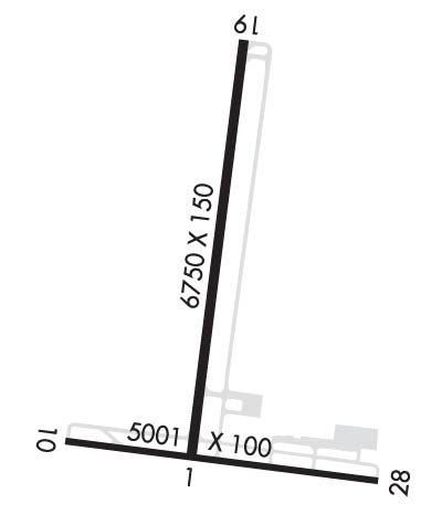
ACTVT MALSR RWY 19; REIL RWY 01, 10 & 28; VASI RWY 10 & 28; MIRL RWY 10/28; HIRL RWY 01/19; TWY LGTS - CTAF. PAPI RWY 01 & 19 SET AT MEDIUM, CTC UNICOM TO CHANGE INTST.
Airport Storage AvailableTie Downs, Hanger
Extra Services AvailableAir Ambulance, Cargo Handling, Charter, Flight Instruction, Aircraft Rental
Wind IndicatorYES - (lighted)
Control TowerNO
CTAF Frequency123.000
Unicom Frequency123.000
Rotating Beacon ColorWG
Segmented CircleNO
Landing FeeNO

Airport Inspection Data

Airport InspectedFEDERAL - performed by FAA AIRPORTS FIELD PERSONNEL
Inspection Date06/13/2023

Airport Services

Type of Fuel AvailableGrade 100LL, JET A (freeze point -40C)
Airframe Repair ServiceMAJOR
Power Plant Repair ServiceMAJOR

Geographic Data

LatitudeN3747.2
LongitudeW08107.5 (ESTIMATED)
Arpt Elevation2503ft (SURVEYED)
Magnetic Variation06W
3 miles Eof BECKLEY
Traffic Pattern Altitude
Sectional ChartCINCINNATI

Aircraft Data

Operations (Reported)YearlyAvg. Daily
General Aviation Transient 1050029
General Aviation Local 920025
Air Taxi 18005
Commerical 00
Commuter 00
Military 20005
Aircraft based on Field
General Aviation Singles 20
General Aviation Multi 7
Jet Aircraft 4
General Aviation Helicopters 1
Military Aircraft 0
Gliders 0
Ultralights 0

FAA Services

FSS on field NO
FSS tie-in ELKINS
FSS Phone 1-800-WX-BRIEF
Who issues Notams BKW
Notam D service at airport YES
ARTCC Name INDIANAPOLIS

Federal Status

Airport CertificationAIRPORT RECEIVING SCHEDULED AIR CARRIER SERVICE FROM CARRIERS CERTIFICATED BY THE CIVIL AERONAUTICS BOARD; PPR 24 HRS FOR UNSKED ACR OPNS WITH MORE THAN 30 PSGR SEATS; CALL AMGR 304-255-0476. INDEX B COVERAGE IS PRVDD.
Aircraft Rescue & Firefighting IndexAIRPORT HAS A CERTIFICATE UNDER CFR PART 139
Airport of EntryNo
Custom Landing RightsNo
Joint Civil/MilitaryNo
Military Landing rightsYES

Federal Agreements

NATIONAL PLAN OF INTEGRATED AIRPORT SYSTEMS (NPIAS)
GRANT AGREEMENTS UNDER FAAP/ADAP/AIP
ASSURANCES PURSUANT TO TITLE VI, CIVIL RIGHTS ACT OF 1964

Remarks

THIS AIRPORT HAS BEEN SURVEYED BY THE NATIONAL GEODETIC SURVEY.
DEER; BIRDS & WILD TURKEYS ON & INVOF ARPT.
Airport Communications & Frequencies:
CTAF Frequency:
123.000
Unicom Frequency:
123.000
CHARLESTON Primary Approach Frequencies:  
125.4
269.125
CHARLESTON Primary Departure Frequencies:  
125.4
269.125
Runway Identifications
Runway Identification: 01/19
Length: 6750 ft
Width: 150 ft
Surface: ASPHALT-GOOD CONDITION
Edge lights: High Intensity

Treatment: GROOVED
Weight: PCN 38 /F/B/W/U

 Runway: 01   Runway: 19
Mag heading: 13°Mag heading: 193°
Rwy Slope: -.69% DownRwy Slope: .69% Up
Approach: Approach: ILS
Pattern: Left TrafficPattern: Left Traffic
Markings: NONPRECISION INSTRUMENTMarkings: PRECISION INSTRUMENT
Marking Condition: GOODMarking Condition: GOOD
Arresting Dev: Arresting Dev:
Lat & Long: N3746.9  W08107.5Lat. & Long.: N3748.0  W08107.4
Elev: 2495.3 ft. MSLElev: 2448.8 ft. MSL
TCH: 40 ft. AGLTCH: 55 ft. AGL
Visual Glide Path: 3.00 degreesVisual Glide Path: 3.00 degrees
Displaced Threshold: NoDisplaced Threshold: No
Touchdown Zone: YESTouchdown Zone: YES
Touchdown Elev.: 2495.4 feetTouchdown Elev.: 2468.2 feet
Visual Glide Slope: 4-Light PAPI on LEFT side of RunwayVisual Glide Slope: 4-Light PAPI on LEFT side of Runway
RVR Equipment: RVR Equipment:
RVV Equipment: NORVV Equipment: NO
Approach Lights: Approach Lights: MALSR - 1,400 foot medium intensity approach lighting system with runway alignment indicator lights
REIL: YESREIL: NO
Centerline Lights: NOCenterline Lights: NO
Touchdown lights: NOTouchdown lights: NO
Runway Category: Runway with a Non-precision Approach having visibility minimums greater than 3/4 mileRunway Category: Precision Instrument Runway
Declared Distances: TORA:6750' TODA:6750' ASDA:6750' LDA:6750'Declared Distances: TORA:6750' TODA:6750' ASDA:6750' LDA:6750'
Runway Identification: 10/28
Length: 5001 ft
Width: 100 ft
Surface: ASPHALT-GOOD CONDITION
Edge lights: Medium Intensity

Treatment: NONE
Weight: PCN 38 /F/B/W/U

 Runway: 10   Runway: 28
Mag heading: 104°Mag heading: 284°
Rwy Slope: .30% UpRwy Slope: -.30% Down
Approach: Approach:
Pattern: Left TrafficPattern: Left Traffic
Markings: NONPRECISION INSTRUMENTMarkings: NONPRECISION INSTRUMENT
Marking Condition: GOODMarking Condition: GOOD
Arresting Dev: Arresting Dev:
Lat & Long: N3747.0  W08108.0Lat. & Long.: N3746.9  W08106.9
Elev: 2485.7 ft. MSLElev: 2500.8 ft. MSL
TCH: 61 ft. AGLTCH: 66 ft. AGL
Visual Glide Path: 3.00 degreesVisual Glide Path: 3.75 degrees
Displaced Threshold: NoDisplaced Threshold: No
Touchdown Zone: YESTouchdown Zone: YES
Touchdown Elev.: 2501.9 feetTouchdown Elev.: 2503.8 feet
Visual Glide Slope: 4-BOX VASI ON RIGHT SIDE OF RUNWAYVisual Glide Slope: 4-BOX VASI ON LEFT SIDE OF RUNWAY; VGSI AND DESCENT ANGLES NOT COINCIDENT.
RVR Equipment: RVR Equipment:
RVV Equipment: NORVV Equipment: NO
Approach Lights: Approach Lights:
REIL: YESREIL: YES
Centerline Lights: NOCenterline Lights: NO
Touchdown lights: NOTouchdown lights: NO
Runway Category: Runway with a Non-precision Approach having visibility minimums greater than 3/4 mileRunway Category: Runway with a Non-precision Approach having visibility minimums greater than 3/4 mile
Declared Distances: TORA:5001' TODA:5001' ASDA:5001' LDA:5001'Declared Distances: TORA:5001' TODA:5001' ASDA:5001' LDA:5001'
Comments: Comments: 9 FT OBSTN LGTD POLE, 125 FT FM AER, 250 FT R.
C:40/P: